Vector data spatial index method based on hbase and geohash

A vector data and spatial index technology is applied to the mapping of dimensional vector data to a one-dimensional string type rowk. The invention relates to the field and can solve the problems of reducing query efficiency, querying disjoint data in areas, reducing precision and the like, and achieving Improve query performance and the effect of efficient query services

Active Publication Date: 2017-06-06
STATE GRID CORP OF CHINA +3
View PDF3 Cites 2 Cited by
  • Summary
  • Abstract
  • Description
  • Claims
  • Application Information

AI Technical Summary

Problems solved by technology

[0008] Geohash’s support for line and surface data has some disadvantages. For example, if the number of divisions of the query area is too large, it may cause the query area to contain too many cell grids, making the retrieval conditions too trivial, increasing the pressure on the database, and reducing the Query efficiency; if the number of divisions corresponding to the query area is too small, the query area may only be a small part of a certain unit grid, resulting in the results retrieved based on Geohash codes containing too much disjoint data in the query area, reducing the precision rate

Method used


Image

  • Vector data spatial index method based on hbase and geohash
  • Vector data spatial index method based on hbase and geohash
  • Vector data spatial index method based on hbase and geohash

Examples


Embodiment Construction

[0035] The technical solution of the present invention will be specifically described below in conjunction with the accompanying drawings.

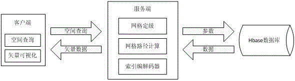
[0036] A kind of vector data spatial indexing method based on hbase and geohash of the present invention comprises the following steps,

[0037] S1: Grid grading: for the vector data to be stored in the Hbase database, divide the grid according to the data classification of points, lines, and surfaces, and determine the number of grid layers for storing vector data, that is, determine the number of grids that need to be divided;

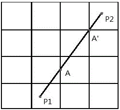
[0038] S2: Grid path calculation: determine a spatial projection coordinate system to determine the starting and ending longitude lng 起 、lng 终 and latitude lat 起 、lat 终 , and calculate the length and width of each grid in each layer, so as to facilitate the mutual conversion between longitude lng, latitude lat, grid row number row, and column number col; Grid calculation, line passing grid calculation and su...


PUM


Abstract

The invention relates to a vector data space indexing method base on hbase and geohash. The method comprises the following steps: firstly, vector data to be stored is subjected to grid grading; secondly, grid path is calculated; then, the structure of a grid list is designed and indexing codes are established; lastly, the space range to be inquired is subjected to space indexing. According to the vector data space indexing method, two-dimensional vector data such as dots, lines and surfaces are mapped into a one-dimensional character string type rowkey index, so that a huge amount of vector data can be stored through the adoption of the hbase, and the high-performance space inquiry analysis service is provided.

Description

technical field [0001] The present invention relates to the method that carries out massive GIS vector data spatial index encoding and establishment on hbase, more specifically, the present invention relates to point, line, surface two-dimensional vector data mapping to one-dimensional string type rowkey index, make It can use hbase to store massive vector data and provide high-performance spatial query and analysis services, especially a vector data spatial index method based on hbase and geohash. Background technique [0002] With the rapid development of mobile network technology and GIS technology, the rapid growth of spatial data, the storage and management of massive spatial data has become a difficult problem. [0003] Using cloud computing to solve the problem of spatial query has become a new direction of consideration. In recent years, in order to solve the problem of large-scale data storage and management, many companies and institutions have proposed a series o...

Claims


Application Information

Patent Timeline
Patent Type & Authority Patents(China)
IPC IPC(8): G06F17/30
CPCG06F16/29G06F16/9537
Inventor 陈强梁曼舒林承华汤振立罗富财吴丹
Owner STATE GRID CORP OF CHINA
Why Eureka
Try Eureka