Land rectification method for coal mining subsidence areas in plain areas

A technology for coal mining subsidence areas and land leveling, which is applied in the fields of land preparation methods, applications, agricultural machinery and equipment, etc., and can solve the problems of no treatment measures, no analysis of the morphological characteristics of coal mining subsidence basins, and extensive treatment methods.

CN104541643AInactive Publication Date: 2015-04-29XIAN UNIV OF SCI & TECH
5 Cites 10 Cited by

Patent Information

Authority / Receiving Office
CN · China
Current Assignee / Owner
Publication Date
2015-04-29
Estimated Expiration
Not applicable · inactive patent

Smart Images

  • Figure 1
    Figure 1
  • Figure 2
    Figure 2
  • Figure 3
    Figure 3
Patent Text Reader

Abstract

The invention discloses a land rectification method for coal mining subsidence areas in plain areas. The method includes 1, treatment region division; according to the spatial distribution features of earth surface distribution curves, dividing the earth surface moving basin into four treatment regions, namely an edge region, a side slope region, a slope base region and a basin base region from exterior to interior; 2, segmented region treatment; treating the edge region by a field internal flattening method, treating the side slope region by the field internal flattening method when the slope angle of the side slope region is smaller than 5 degrees and treating by a level terrace method when the slope angle of the side slope region is not smaller than 5 degrees, treating the slope base region by the field internal flattening method, and treating the basin base region by the method combing intercepting ditches and pumping stations. The method of 'segmented treatment and partial optimization' is adopted, the steps are simple, design is reasonable, implementation is facilitated, treatment effect is fine, and the earth surface moving basin of the plain area caused by coal mining can be treated effectively.
Need to check novelty before this filing date? Find Prior Art

Description

technical field

[0001] The invention belongs to the technical field of coal mining subsidence area control, and in particular relates to a method for land improvement in a coal mining subsidence area in a plain area. Background technique

[0002] Coal is the most important energy source in our country, and 90% of the coal resources are mined through wells. Mining subsidence has caused a large amount of land damage. How to scientifically control subsidence and damaged land is an urgent requirement for the protection of cultivated land and environmental restoration of mining areas in my country. Due to the wide distribution of coal resources in my country, different natural conditions, large differences in resource endowments, and various forms of land damage, a unified governance model cannot be formed. It is necessary to develop suitable governance methods for specific damage conditions in different types of areas.

[0003] The ground surface movement basin is the range of ...

Examples

Embodiment Construction

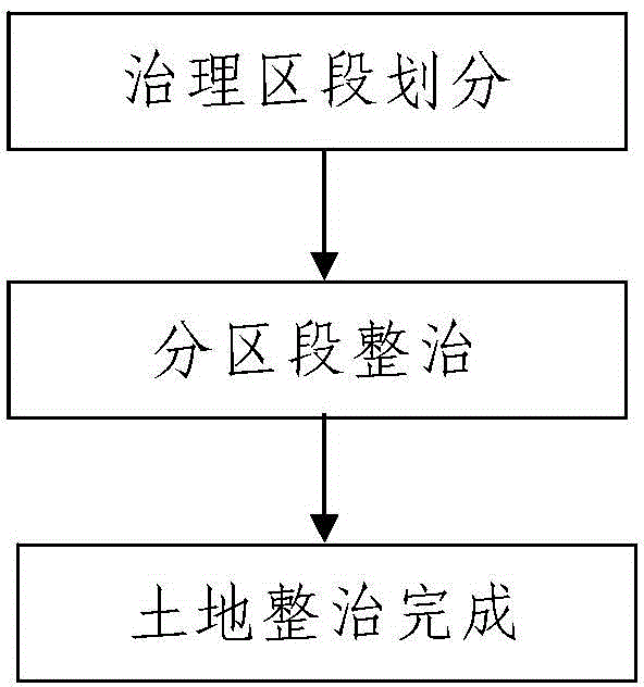
[0063] Such as figure 1 A method of land consolidation in the coal mining subsidence area shown in the plain area is used for land consolidation in the surface mobile basin in the coal mining subsidence area. The process is as follows:

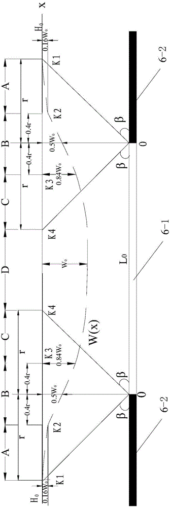
[0064] Step 1. Division of treatment sections: Divide the surface mobile basin to be rehabilitated into four treatment sections from outside to inside; the four treatment sections are respectively edge area, side slope area, and slope bottom from outside to inside area and a basin floor area, the basin floor area is located in the middle of the surface mobile basin.

[0065] Such as figure 2 As shown, on the main cross-section of the movement of the surface basin, the area from the boundary point K1 to the boundary point K2 of the surface movement basin is the edge area, and the area from the boundary point K2 to the boundary point K3 is the slope area, and the area between the boundary point K3 and the maximum subsidence point K4 is the sl...