Radar image simulation-oriented terrain environment data representing method

A technology of terrain data and environmental data, which is applied in the field of simulation, can solve problems affecting the realistic experience of the simulation system, repeated development of databases, synchronization of heterogeneous systems and limited data interaction, etc.

Inactive Publication Date: 2016-04-13
NAVAL AERONAUTICAL & ASTRONAUTICAL UNIV PLA
View PDF2 Cites 9 Cited by
  • Summary
  • Abstract
  • Description
  • Claims
  • Application Information

AI Technical Summary

Problems solved by technology

The quality of the environmental data model directly affects the realistic experience of the simulation system. In the composition of the simulation system, there are two heterogeneous problems: (1) different training systems (2) different subsystems in the same training system
There is usually data

Method used


Image

  • Radar image simulation-oriented terrain environment data representing method
  • Radar image simulation-oriented terrain environment data representing method
  • Radar image simulation-oriented terrain environment data representing method

Examples


Embodiment Construction

[0041] The present invention will be described in further detail below in conjunction with the accompanying drawings and examples.

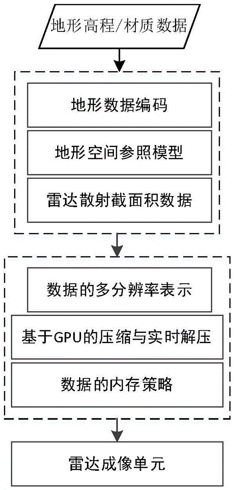
[0042] The overall flow chart of the representation method for constructing terrain environment data in the present invention is as follows figure 1As shown, the method is mainly composed of two parts: static storage representation of data and simulation dynamic representation of data. The specific implementation steps are as follows:

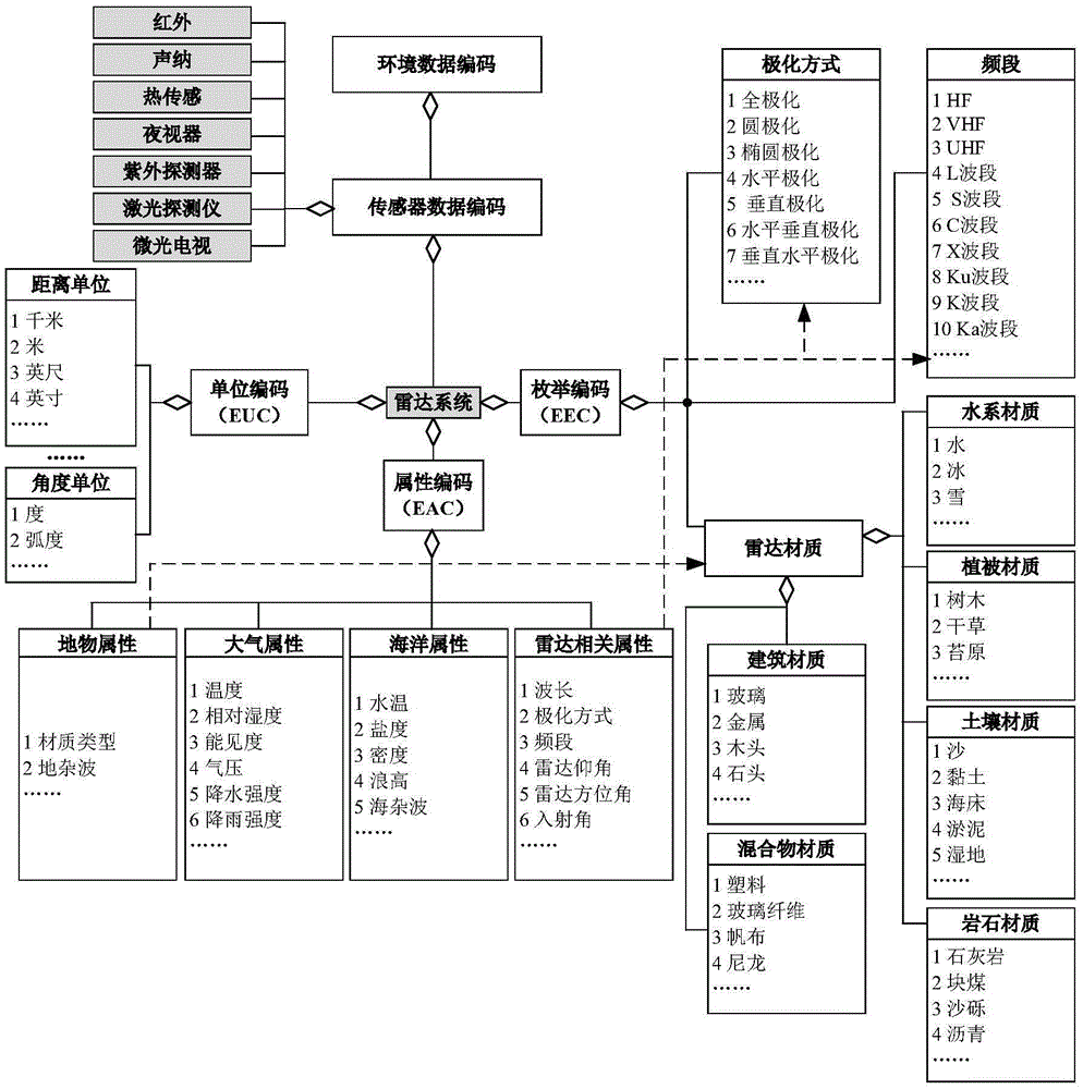
[0043] 1. Construct the encoded representation of terrain data, the encoding method is as follows figure 2 as shown, figure 2 According to the types of ground features, several typical types of ground features are displayed, such as water system, vegetation, soil, buildings, etc.; in the enumeration code, the relevant electromagnetic characteristic parameters in radar simulation and the enumeration type of radar material are defined, among which The electromagnetic characteristics are divided into polarization...


PUM


Abstract

The invention discloses a radar image simulation-oriented terrain environment data representing method and belongs to the technical field of simulations. The method is used for constructing radar terrain databases which have consistent representation and are used for simulating real environments. The method disclosed by the invention comprises the following steps: 1, constructing the static storage representation of terrain data, comprising a terrain data coding method, a terrain space reference model and a radar terrain scattering sectional area data representation; and 2, constructing simulation dynamic representation of the terrain data, comprising detail level structure constructing and a real-time memory scheduling method of data. The method disclosed by the invention is mainly used for the ground imaging simulation in an airborne radar simulation system, is an essential constitution for developing the real-time radar simulation system and has a broad application prospect in the aspects of flight simulation training and radar design.

Description

technical field [0001] The invention belongs to the technical field of simulation, and in particular relates to a terrain modeling method and system for radar terrain imaging simulation. Background technique [0002] In the simulation system, the environmental data directly affect the performance of the simulation system. Different simulation systems are usually in the same physical environment during simulation, and the environment includes terrain, ocean, atmosphere, etc. The quality of the environmental data model directly affects the realistic experience of the simulation system. In the composition of the simulation system, there are two heterogeneous problems: (1) different training systems and (2) different subsystems in the same training system. There is usually data interaction and synchronization between these systems. Traditional simulation systems use independent databases, which will lead to problems such as poor data consistency, limited synchronization and data...

Claims


Application Information

Patent Timeline
IPC IPC(8): G06T15/00G06T17/05
CPCG06T15/005G06T17/05
Inventor 张立民张建廷邓向阳方伟方君
Owner NAVAL AERONAUTICAL & ASTRONAUTICAL UNIV PLA
Why Eureka
Try Eureka