Automatically extracting method for river-valley morphological parameters based on DEM

A morphological parameter, automatic extraction technology, applied in 3D modeling, image data processing, structured data retrieval, etc.

Inactive Publication Date: 2016-07-06
CHINA AERO GEOPHYSICAL SURVEY & REMOTE SENSING CENT FOR LAND & RESOURCES
View PDF2 Cites 23 Cited by
  • Summary
  • Abstract
  • Description
  • Claims
  • Application Information

AI Technical Summary

Problems solved by technology

[0004] The object of the present invention is to provide a kind of automatic extraction method of

Method used


Image

  • Automatically extracting method for river-valley morphological parameters based on DEM
  • Automatically extracting method for river-valley morphological parameters based on DEM
  • Automatically extracting method for river-valley morphological parameters based on DEM

Examples


Embodiment 1

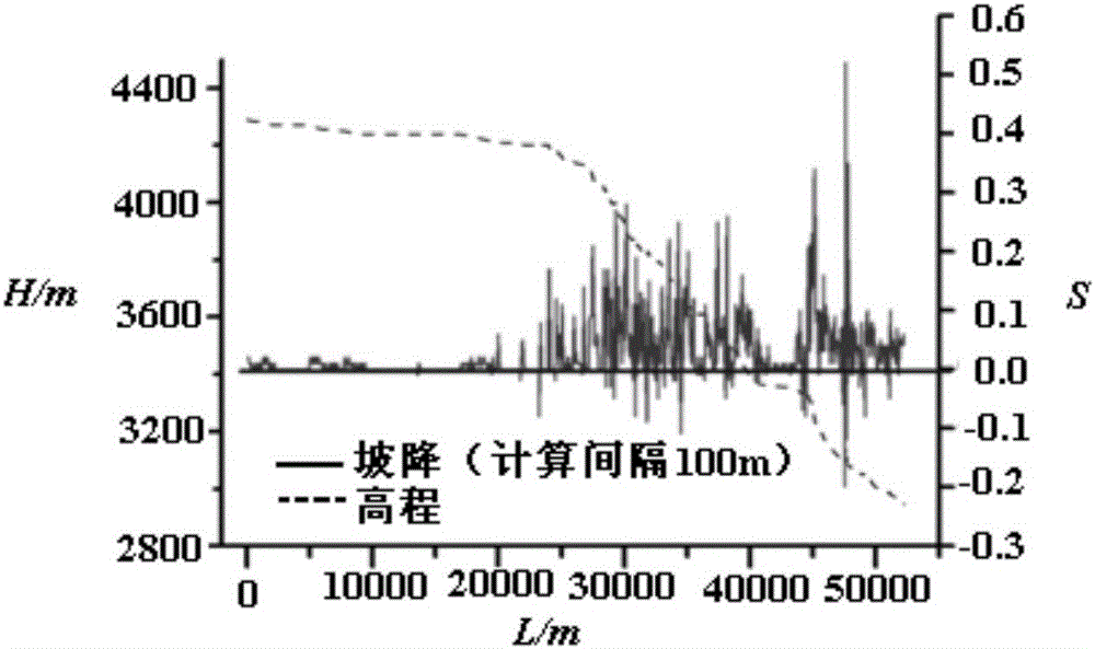
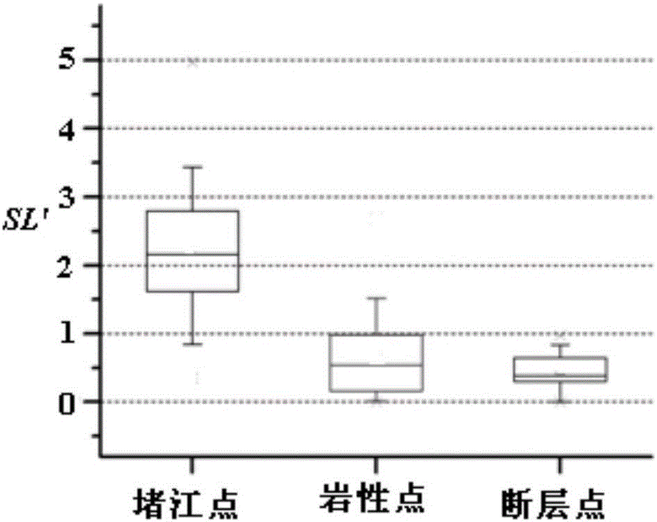
[0137] This method was used to extract the distribution of the standardized river length-slope index SL' of Khambu Maqu and its tributaries in Yadong County, Tibet Autonomous Region, China, and based on the index, the automatic identification and application analysis of landslide blockage time was carried out.

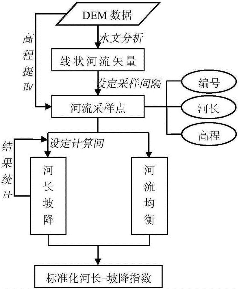
[0138] 1. Data source and topographic point SL’ extraction

[0139] Using the 1:50,000 topographic map digitized DEM (spatial resolution about 25m) as the basic data, the equilibrium slope K of the 10 main rivers in the watershed was extracted and calculated, and the Kangbu Maqu and its tributaries were calculated at a sampling interval of 50m SL' of all sampling points in the valley longitudinal profile.

[0140] Due to the relatively small area of ​​the study area and the relatively regular shape of the water system, this application does not consider the influence of factors such as climate change and river encroachment on the evolution of the river landform in the ...

Embodiment 2

[0160] Using this method, taking the geographical locations of the river blocking landslides and non-blocking river landslide events that have occurred in the Himalayas of China as the positioning points, the morphological parameters of the valley cross section where each point is located are automatically extracted, and a model is established based on the above parameters to analyze the impact of landslides. The topographical sensitivity of river blocking can be verified, and the ability evaluation of landslide body blocking river can be realized.

[0161] 1. Automatic extraction of data source and morphological parameters of valley cross section

[0162] The basic data for calculating the morphological parameters of the cross-section of the valley include the elevation data covering the Himalayas in China and the location points of landslides and non-blocking river landslides. This application selects ASTERGDEMv2 with 30m resolution as the elevation data source. The geograp...


PUM


Abstract

The invention discloses an automatically extracting method for the river-valley morphological parameters based on DEM, and relates to the field of digital geomorphology analysis. The automatically extracting method includes the steps that DEM data for analyzing a river-valley drainage basin is obtained; all rivers belonging to the river-valley drainage basin are obtained and numbered, and sampling points of a longitudinal section are taken at a certain sampling interval a; the morphological parameters of the longitudinal section of a river valley and the morphological parameters of the transverse section of the river valley are calculated. By means of the automatically extracting method, river-valley geomorphology and subsection difference can be represented in the microscopic view, and the whole terrain of the river valley can be analyzed; representation is comprehensive; the calculated parameters are small in interference factor and high in accuracy and operation efficiency.

Description

technical field [0001] The invention relates to the field of digital landform analysis, in particular to a DEM-based method for automatically extracting river valley morphological parameters. Background technique [0002] Calculation of the morphological parameters of the vertical profile and cross-section of the valley is an important part of the study of valley geomorphology: the morphological parameters of the vertical profile of the valley can reflect the physical erosion process of the river and the dynamic conditions of the incision of each river section, and reveal the influence of the river geomorphology on lithology, structure, climate, etc. The corresponding mechanism of the conditions; the valley cross section is a geometric body composed of the valley bottom channel and the slopes on both sides. Its shape changes continuously along the river direction. Its morphological parameters help to judge the valley type and development degree, and assist in the in-depth ana...

Claims


Application Information

Patent Timeline
IPC IPC(8): G06F17/30G06T17/05
CPCG06F16/29G06F16/56G06T17/05G06T2207/20036
Inventor 王珊珊童立强郭兆成贺鹏涂杰楠
Owner CHINA AERO GEOPHYSICAL SURVEY & REMOTE SENSING CENT FOR LAND & RESOURCES
Why Eureka
Try Eureka