Geological-disaster emergency commanding system based on GIS

A technology for emergency command and geological disasters, applied in the field of emergency systems, can solve problems such as inconvenience and intuition, and achieve the effect of comprehensive management

Inactive Publication Date: 2017-10-03
安徽山鼎信息科技有限公司
View PDF4 Cites 12 Cited by
  • Summary
  • Abstract
  • Description
  • Claims
  • Application Information

AI Technical Summary

Problems solved by technology

In order to cultivate and promote the self-prevention, monitoring, and avoidance awareness and ability of township and village grassroots cadres, many township departments have geological disaster prevention and control plans, mass transfer plans, and geological disaster prevention and control duty, monitoring, inspection and quick reporting systems , there are persons i

Method used


Image

  • Geological-disaster emergency commanding system based on GIS

Examples


Embodiment Construction

[0023] The following will clearly and completely describe the technical solutions in the embodiments of the present invention with reference to the accompanying drawings in the embodiments of the present invention. Obviously, the described embodiments are only some of the embodiments of the present invention, not all of them. Based on the embodiments of the present invention, all other embodiments obtained by persons of ordinary skill in the art without creative efforts fall within the protection scope of the present invention.

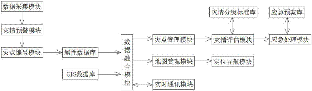
[0024] Such as figure 1 As shown, the present invention provides a kind of geological disaster emergency command system based on GIS, including data acquisition module, disaster early warning module, disaster point numbering module, attribute database, GIS database, data fusion module, map management module, positioning navigation module, Disaster point management module, disaster assessment module, disaster classification standard library, emergency ...


PUM


Abstract

The invention discloses a geological-disaster emergency commanding system based on a GIS. The geological-disaster emergency commanding system comprises a data collecting module, a disaster-situation early warning module, a disaster point numbering module, an attribute database, a GIS database, a data fusion module, a map management module, a positioning navigation module, a disaster point management module, a disaster-situation evaluation module, a disaster-situation grading standard library, an emergency treatment module, an emergency plan library and a real-time communication module. Geological-disaster control departments of all regions can query detailed information of geologic attributes of all disaster points, and therefore comprehensive management of disaster points is achieved; meanwhile, emergency plans when disasters occur can be directly and rapidly displayed, and a direct and rapid solution is provided for pre-disaster early warning, disaster commanding and post-disaster rescuing.

Description

technical field [0001] The invention belongs to the technical field of emergency systems, and relates to a geological disaster emergency command system, in particular to a GIS-based geological disaster emergency command system. Background technique [0002] my country's geological disasters are many and widespread, and sudden disasters such as landslides, collapses, mudslides, and subsidences of different scales occur from time to time. In order to cultivate and promote the self-prevention, monitoring, and avoidance awareness and ability of township and village grassroots cadres, many township departments have geological disaster prevention and control plans, mass transfer plans, and geological disaster prevention and control duty, monitoring, inspection and quick reporting systems , there are persons in charge of geological disaster prevention, monitors, coordinators, geological disaster prevention and monitoring tools, and communication tools, which provide valuable inform...

Claims


Application Information

Patent Timeline
IPC IPC(8): G06F17/30G06Q50/26G08B21/10
CPCG06F16/29G06Q50/26G08B21/10
Inventor 朱杭斌夏旻
Owner 安徽山鼎信息科技有限公司
Why Eureka
Try Eureka