Reducing latency in map interfaces

A map and user interface technology, applied in image enhancement, image analysis, image coding, etc., can solve problems such as occupying a large amount of resources, and achieve the effects of reducing demand, increasing speed, and reducing delay

Pending Publication Date: 2017-10-03
GOOGLE LLC
View PDF8 Cites 1 Cited by
  • Summary
  • Abstract
  • Description
  • Claims
  • Application Information

AI Technical Summary

Problems solved by technology

Since these map user interfaces can include a large amount of information and can be generated using many different scripts, canvases, and graphics, rendering the map can be resource intensive and take some time to render at the client device

Method used


Image

  • Reducing latency in map interfaces
  • Reducing latency in map interfaces
  • Reducing latency in map interfaces

Examples


Embodiment Construction

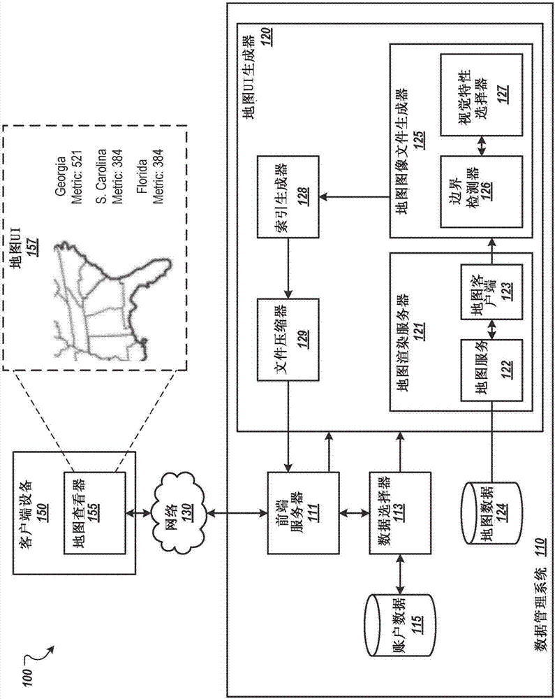
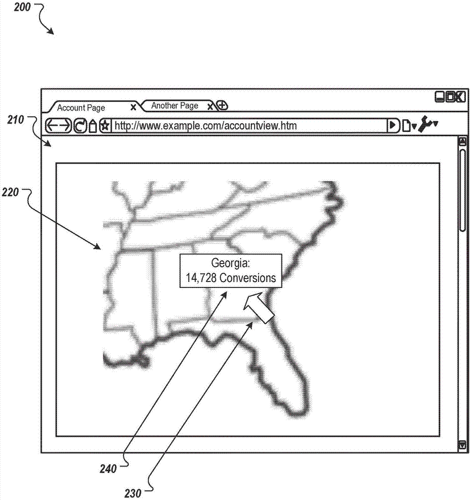
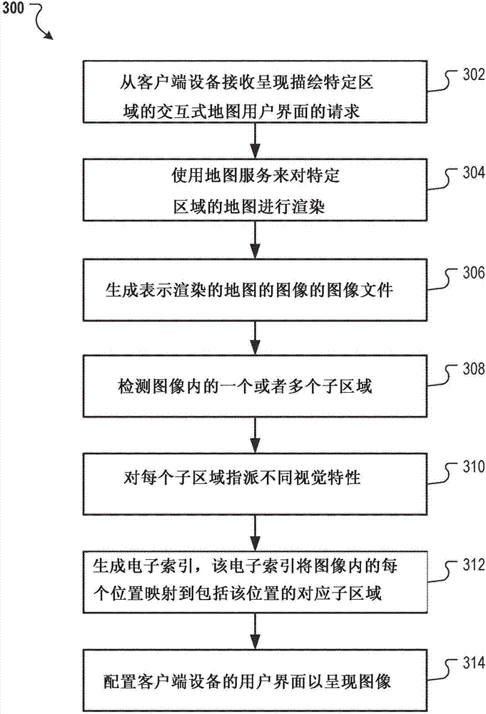
[0016] The system can reduce the delay in providing and presenting the interactive map user interface. For example, the system can generate an image of a map generated by a map service. The image can depict a map of a specific area and its sub-areas. The system may also generate an electronic index that maps a location within the image (for example, the x-y coordinates of the image) to a sub-region of the image and provides the electronic index and the image to the client device. The electronic index can also map sub-regions to data in sub-regions. In this way, for example, when the user interacts with the image of the map at the location corresponding to the specific sub-region by hovering over the location corresponding to the sub-region or selecting the location, the The user presents the data of the sub-region.

[0017] For example, providing images to a client device via the Internet may require fewer computing resources and network resources than using a map service at t...


PUM


Abstract

Methods, systems, and apparatus, including computer programs encoded on a computer storage medium, for reducing latency in transmitting and presenting map user interfaces. In one aspect, a method includes receiving, from a client device, a request for presentation of an interactive map user interface that depicts (i) a region and (ii) data related to an account for sub-regions of the region. One or more servers render a map of the region. The server(s) generate an image file representing an image of the rendered map. A different visual characteristic is assigned to each different sub-region. The server(s) configure a user interface of the client device to present (i) the image with each of the different sub-regions being presented according to the different visual characteristics and (ii) account data related to a sub-region when the client device detects a user interaction with the sub-region.

Description

Background technique [0001] The Internet facilitates the exchange of information and transactions among users worldwide. This information exchange enables data providers to provide data to various users. An example of information provided on the Internet is an interactive map that enables users to search and view maps of a specific area. Since these map user interfaces can include a large amount of information and can be generated by using many different scripts, canvases, and graphics, rendering the map may consume a lot of resources and take some time to render at the client device. Summary of the invention [0002] This specification describes techniques related to reducing the delay in transmitting and presenting the map user interface. [0003] Generally speaking, an innovative aspect of the subject described in this specification can be implemented as a method comprising the following actions: receiving a request from a client device to present an interactive map user inter...

Claims


Application Information

Patent Timeline
Patent Type & Authority Applications(China)
IPC IPC(8): G06T11/40
CPCG06T11/40G06F16/29G06F16/51G06T7/11G06F3/04842G06T1/20G06T11/001G06T11/20G06F2203/04806G06T3/40G06T9/00G06T2207/20104G06T1/60G06T2200/16G06F16/60G06F16/63
Inventor 尼克希尔·巴克希奥利弗·迈克尔·金泽夫·内特尔顿·尤拉
Owner GOOGLE LLC
Why Eureka
Try Eureka