Mobile GIS visual method based on dynamic map symbols

A technology of map symbols and dynamic maps, which is applied in the field of dynamic map symbols of mobile GIS visualization method, and can solve problems such as symbol distortion, multi-memory, and difficult-to-monitor data real-time visualization

Inactive Publication Date: 2017-11-24
NANJING UNIV OF POSTS & TELECOMM
View PDF2 Cites 6 Cited by
  • Summary
  • Abstract
  • Description
  • Claims
  • Application Information

AI Technical Summary

Problems solved by technology

Among them, the method of visually expressing map symbols based on tile image format on a mobile map is simple and easy to operate, but when the amount of map symbol data is large, tile image format graphics occupy more memory, and the zoom operation of the map It will directly lead to the distortion of symbols; the visual expression of m

Method used


Image

  • Mobile GIS visual method based on dynamic map symbols
  • Mobile GIS visual method based on dynamic map symbols
  • Mobile GIS visual method based on dynamic map symbols

Examples


Embodiment Construction

[0027] specific implementation plan

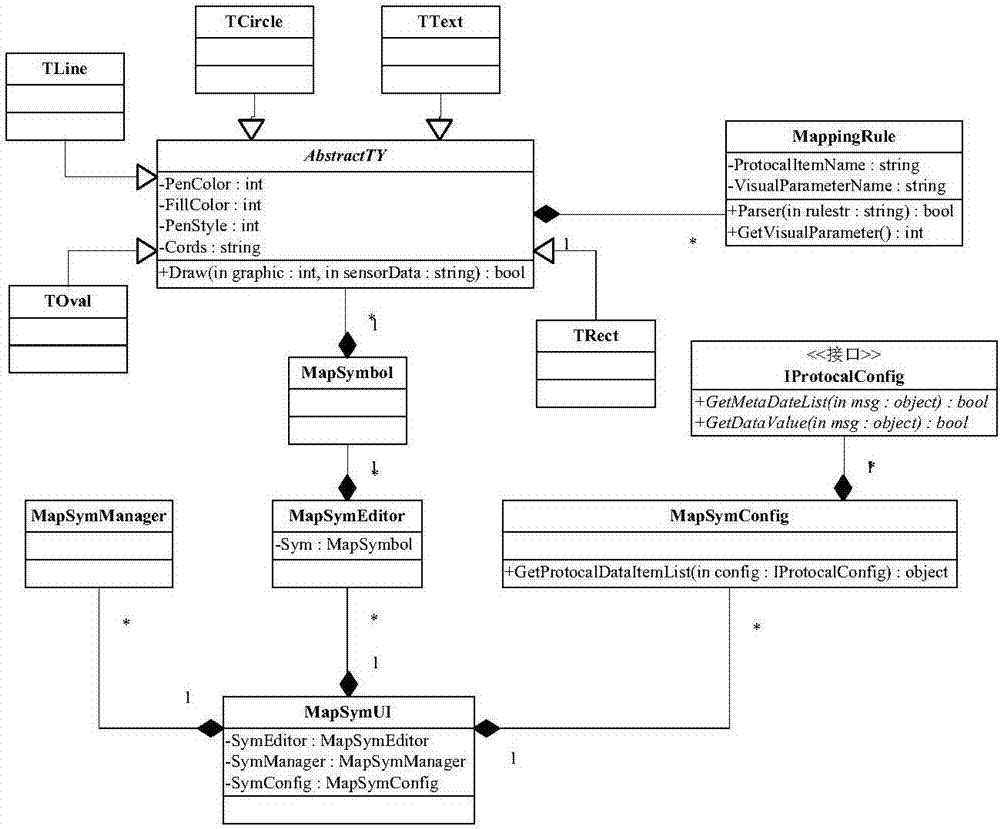
[0028] (1) Mapping rules and definitions of symbolic primitives and real-time data

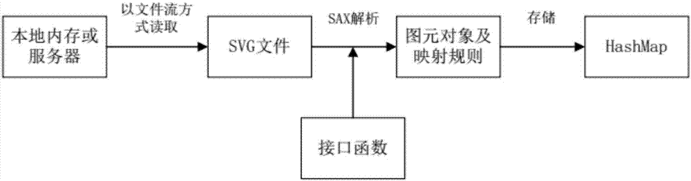
[0029] To realize real-time visualization of equipment and facility data based on map symbols, it is necessary to create mapping rules between map symbol primitives and sensor device data that are suitable for the characteristics of the data according to the characteristics of the device data.

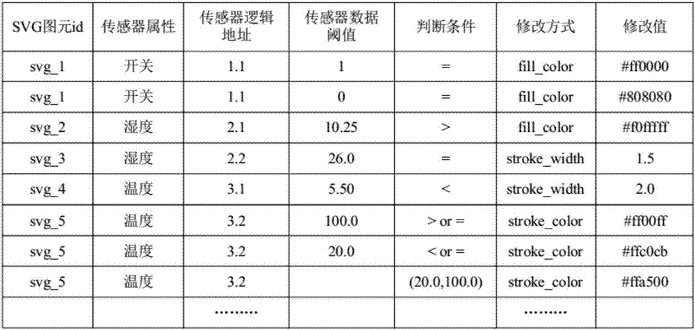
[0030] In order to distinguish primitives of the same type with different element attribute values, a new attribute value ID number is added to each primitive description label, that is, all symbol primitives in the vector map symbol file have unique ID number values. The mapping rule between the mobile monitoring equipment data and the visual variables of map symbols is to retrieve the primitives that meet the mapping requirements through this ID number, and modify the attribute values ​​of the primitives according to the mapping requirements to achieve different ...


PUM


Abstract

The invention discloses a mobile GIS visual method based on dynamic map symbols. The mobile GIS visual method based on dynamic map symbols comprises the following steps: taking visual variable research of traditional map symbols as basis, combining the design, visual display and mobile communication protocol of geographic entity symbols; establishing a mapping relation between different types of real-time data and geographic entity symbol visual variable according to different variable types and data types of mobile monitoring equipment; carrying out data interaction between a mobile terminal and monitoring equipment by a customized communication protocol and a real-time communication protocol; and when data are changed, mapping parameter change on a mobile GIS map through map symbols, and rendering and drawing the map symbols again so as to realize real-time visualization of the dynamic map symbols of the mobile GIS.

Description

technical field [0001] The present invention specifically relates to the technical field of a mobile GIS visualization method based on dynamic map symbols dynamic map symbols Background technique [0002] With the high integration of mobile devices and the rapid development of processors, the computing and processing capabilities of terminal devices are continuously enhanced, and the application fields of mobile GIS are becoming more and more extensive. Data visualization based on mobile GIS is visually expressed through the map symbols of the mobile map module, and there are mainly two ways of expression: vector graphics and tile images. Among them, the method of visually expressing map symbols based on tile image format on a mobile map is simple and easy to operate, but when the amount of map symbol data is large, tile image format graphics occupy more memory, and the zoom operation of the map It will directly lead to the distortion of symbols; the visual expression of ma...

Claims


Application Information

Patent Timeline
IPC IPC(8): G06F17/30G06T11/20
CPCG06F16/29G06F16/904G06T11/206
Inventor 姜杰焦东来朱少楠陈雪飞
Owner NANJING UNIV OF POSTS & TELECOMM
Why Eureka
Try Eureka