Satellite radar inversion fusion method based on NRIET machine learning

A fusion method and machine learning technology, applied in the field of radar echo inversion and fusion algorithm, which can solve the problems of increasing uncertainty factors, result errors, and inability to obtain high temporal resolution precipitation data.

Active Publication Date: 2018-08-24
NANJING NRIET IND CORP
View PDF5 Cites 18 Cited by
  • Summary
  • Abstract
  • Description
  • Claims
  • Application Information

AI Technical Summary

Problems solved by technology

The principle of this method is simple, but the result error is large, and there is no data for visible light at night
Microwave radiometers are currently only installed on polar-orbiting satellites, and the repetition period of polar-orbiting satellites usually takes 1 day, and precipitation data with high temporal resolution cannot be obtained.
And this method introduces precipitation intensity as an intermediate variable, and establishes the relationship between satellite observation and precipitation and radar echo and precipitation respectively, which increases the uncertainty factors

Method used


Image

  • Satellite radar inversion fusion method based on NRIET machine learning
  • Satellite radar inversion fusion method based on NRIET machine learning
  • Satellite radar inversion fusion method based on NRIET machine learning

Examples


Embodiment Construction

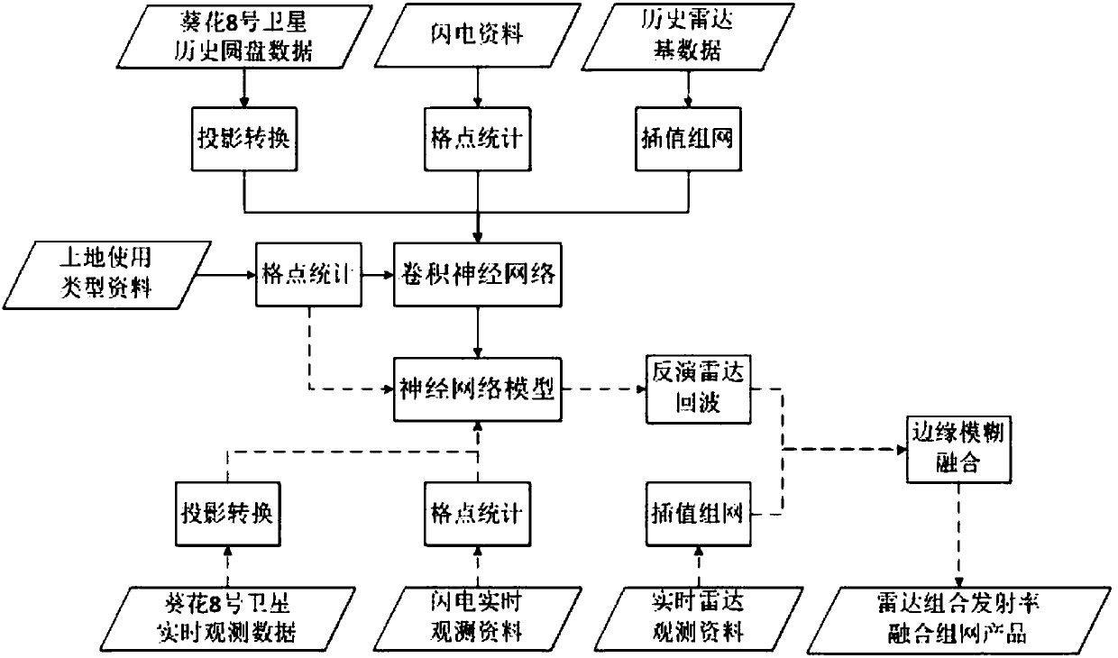
[0070] Attached below figure 1 The present invention will be specifically described.

[0071] Based on the data of 13 S-band radars in Jiangsu Province in October 2016 and the lightning data of the corresponding time period, the data of the Sunflower 8 geostationary satellite and the data of MODIS land use types, the Tensorflow convolutional neural network was used for model training. First, the disk projection data, radar base data, ground observation lightning data, and MODIS land use type data interpolation of Sunflower 8 geostationary satellite are unified to a unified longitude and latitude grid point; , Lightning data and land use type data are used as input, and radar combined reflectance data is used as output to train the neural network; finally, the real-time observation data is input into the trained neural network model to obtain the inverted radar echo, and use edge fuzzy fusion In this way, the observed radar combined reflectivity and the retrieved radar combine...


PUM


Abstract

The invention discloses a satellite radar inversion fusion method based on NRIET machine learning. The method comprises a training phase and an inversion phase. The training phase includes satellite data and processing: subjecting the disc projection data of four waveband including B08, B10, B13 and B15 of a sunflower No. 8 geostationary satellite to projection conversion and interpolating the same to a spatial grid point of 0.02*0.02 degree; lightning data and processing; radar data and radar data networking; land use type data and processing; and model training. The inversion phase includes:data preprocessing: subjecting the sunflower No. 8 geostationary satellite data obtained by real-time observation and the lightning data to the same processing as the training phase, the land use type data using the data processed in the training phase; the radar data networking: subjecting the radar-base data observed in real time to networking according to the networking steps in the training phase to calculate the combined emissivity; radar echo inversion; and satellite radar data fusion.

Description

technical field [0001] The invention relates to a radar echo inversion and fusion algorithm, in particular to an NRIET machine learning-based satellite radar inversion and fusion method. Background technique [0002] The existing radar observation range is limited. In the western region where radar deployment is relatively sparse, there is a large gap in the radar network. At the same time, the radar's observation range at sea is limited and can only cover offshore areas. In order to make up for the gaps in the radar network and the lack of maritime observations, a set of radar combined reflectivity algorithms based on satellite observation data has been developed. At present, this technology is not widely used, and the existing algorithms can be roughly divided into two categories: machine learning algorithms based on backpropagation (BP) neural network and radar echo inversion algorithms based on inversion of precipitation. However, both algorithms have certain limitatio...

Claims


Application Information

Patent Timeline
IPC IPC(8): G01S7/41G06N3/04
CPCG01S7/41G01S7/417G06N3/045
Inventor 万秉成
Owner NANJING NRIET IND CORP
Why Eureka
Try Eureka