A soil nutrient classification map generation method based on 3S technology and precision evaluation method thereof

A soil nutrient and grade classification technology, which is applied in the field of remote sensing data analysis and can solve problems such as difficulty in realizing the classification of soil nutrient grades in a large space.

Active Publication Date: 2018-12-07
ANHUI UNIVERSITY +1
View PDF5 Cites 7 Cited by
  • Summary
  • Abstract
  • Description
  • Claims
  • Application Information

AI Technical Summary

Problems solved by technology

[0005] The purpose of the present invention is to solve the defect that it is difficult to realize the division of soil nutrient grades in a large space in the prior a

Method used


Image

  • A soil nutrient classification map generation method based on 3S technology and precision evaluation method thereof
  • A soil nutrient classification map generation method based on 3S technology and precision evaluation method thereof
  • A soil nutrient classification map generation method based on 3S technology and precision evaluation method thereof

Examples


Embodiment Construction

[0068] In order to have a further understanding and understanding of the structural features of the present invention and the achieved effects, the preferred embodiments and accompanying drawings are used for a detailed description, as follows:

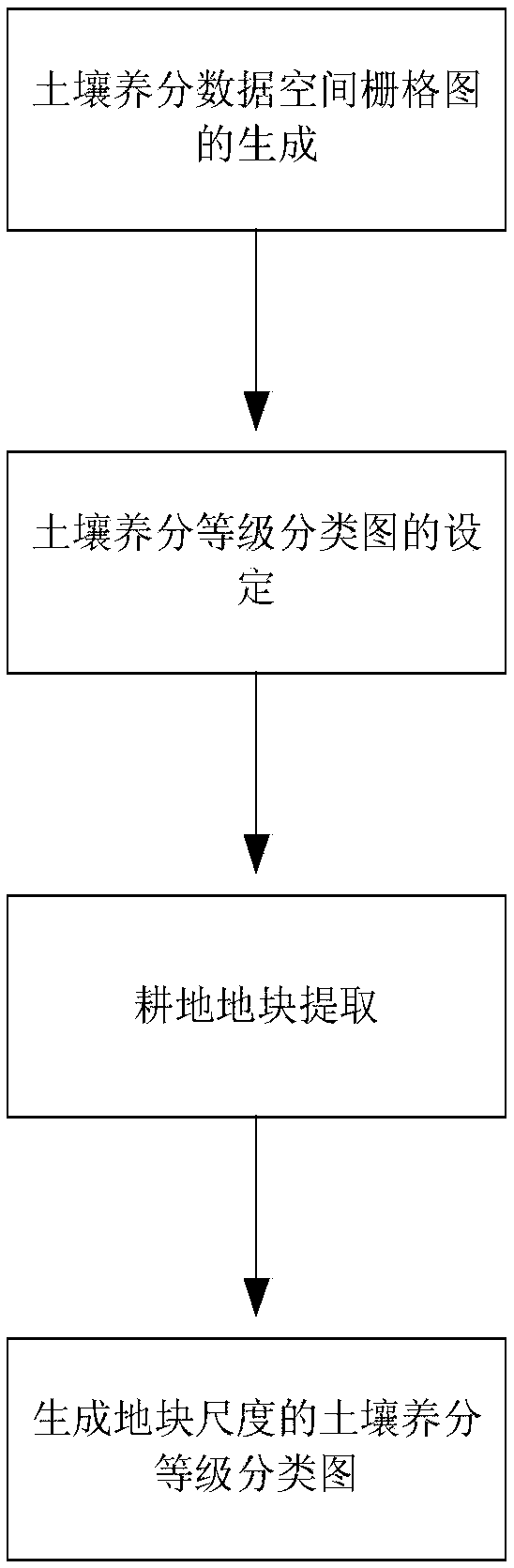
[0069] like figure 1 As shown, a kind of soil nutrient grade classification map generation method based on 3S technology of the present invention, comprises the following steps:

[0070] The first step is the generation of spatial raster map of soil nutrient data. Select the radial basis function RBF (Radial Basis Function) spatial difference method for spatial difference to generate a raster map of each nutrient. The specific steps are as follows:

[0071] (1) When collecting soil samples in the cultivated land, the longitude and latitude coordinates of the sampling points were obtained using a sub-meter-level high-precision handheld GPS, and imported into the ArcMap spatial analysis platform to generate point vector files in Shape...


PUM


Abstract

The invention relates to a soil nutrient classification map generation method based on 3S technology and a precision evaluation method thereof, which solve the defect that it is difficult to realize the soil nutrient classification in a large space range compared with the prior art. The soil nutrient classification map generation method comprises the following steps: generating a spatial raster map of soil nutrient data; setting a classification map of soil nutrients; carrying out cultivated land extraction; generating a plot-scale soil nutrient classification map. The invention is based on 3Stechnology. Based on the field sampling points and RS extracted from cultivated land by GPS, the spatial distribution characteristics of soil nutrients at the plot scale are analyzed by using GIS spatial analysis and geostatistics, and the soil nutrient classification, spatial mapping and precision evaluation at the plot scale are realized in a large spatial range.

Description

technical field [0001] The invention relates to the technical field of remote sensing data analysis, in particular to a method for generating a soil nutrient classification map based on 3S technology and a method for evaluating its accuracy. Background technique [0002] Soil quality is an important criterion for determining the quality of cultivated land. The soil quality of arable land has important economic value in areas with rapid economic development, but it is greatly affected by the environment and shows the characteristics of variation. The current research on cultivated land has developed from focusing only on quantity to paying equal attention to quantity, quality and ecological benefits. On the premise of ensuring the quantity of cultivated land, how to improve the quality of cultivated land, especially the evaluation of its environmental quality, has become a hot research direction of cultivated land. The grading and grading of soil nutrients is of great signi...

Claims


Application Information

Patent Timeline
IPC IPC(8): G06F17/30G06N3/08G06Q10/06
CPCG06N3/08G06Q10/0639
Inventor 赵晋陵董莹莹黄林生梁栋徐超张东彦阮莉敏翁士状
Owner ANHUI UNIVERSITY
Why Eureka
Try Eureka