A multi-target tracking method and a multi-target tracking system fused with geographic space information

A geospatial information, multi-target tracking technology, applied in closed-circuit television systems, image data processing, instruments, etc., can solve problems such as poor visual effects, and achieve the effect of increasing reliability and reducing interference signals

Inactive Publication Date: 2019-06-25
PLA STRATEGIC SUPPORT FORCE INFORMATION ENG UNIV PLA SSF IEU
View PDF5 Cites 21 Cited by
  • Summary
  • Abstract
  • Description
  • Claims
  • Application Information

AI Technical Summary

Problems solved by technology

[0005] The purpose of the present invention is to provide a multi-target tracking method that integrates geospatial information, which is used to solve the problem of visual effects caused by the fact that the target trajectory obtained in the current multi-target tracking process is only the position on the image and is not combined with the actual geographic sp

Method used


Image

  • A multi-target tracking method and a multi-target tracking system fused with geographic space information
  • A multi-target tracking method and a multi-target tracking system fused with geographic space information
  • A multi-target tracking method and a multi-target tracking system fused with geographic space information

Examples


Embodiment Construction

[0055] The technical solution of the present invention will be further described below in conjunction with specific embodiments.

[0056] Method example:

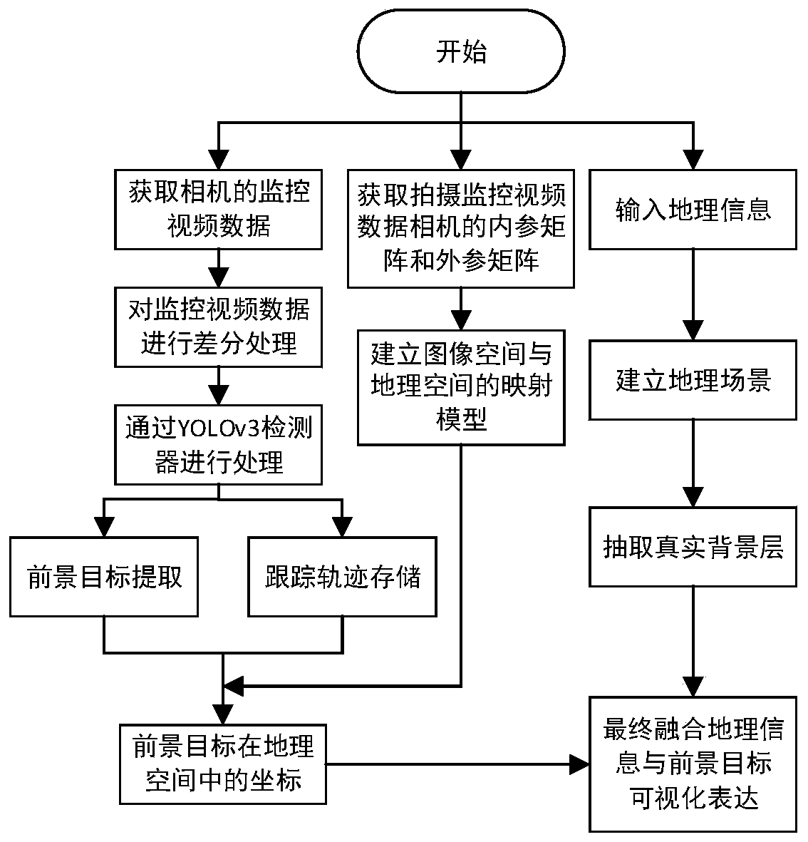
[0057] This embodiment provides a multi-target tracking method that integrates geospatial information, which is used to perform multi-target tracking on the video data acquired by the surveillance camera, and solves the problem that the target motion trajectory obtained in the current multi-target tracking process is only the position on the image. It is not combined with the actual geographical space, and the visual effect is poor.

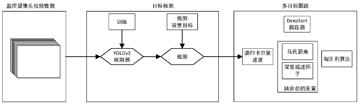
[0058] The multi-target tracking method of integrating geospatial information provided by this embodiment, the processing flow of which is as follows figure 1 As shown, the transfer direction of data during processing is as follows figure 2 As shown, the multi-target tracking method for fusing geospatial information includes the following steps:

[0059] (1) Obtain the internal reference m...


PUM


Abstract

The invention provides a multi-target tracking method and system fusing geographic space information, and the method comprises the following steps: obtaining an internal parameter matrix and an external parameter matrix of a camera which shoots monitoring video data, and building a mapping model of an image space and a geographic space according to the internal parameter matrix and the external parameter matrix of the camera; Obtaining monitoring video data of a camera, performing target detection on the monitoring video data to obtain a foreground target, and tracking the foreground target toobtain a tracking track of the foreground target; And converting the obtained foreground target and the foreground target tracking trajectory into a geographic space by using the mapping model, and fusing the converted foreground target and foreground target tracking trajectory with a real map to realize visual expression of foreground target tracking in the real map. According to the technical scheme provided by the invention, the visual expression of the foreground target tracking in the real map can be obtained, and the problem that the visual effect of the tracking result is poor due to the fact that the foreground target tracking is not combined with the actual geographic space during multi-target tracking is solved.

Description

technical field [0001] The invention belongs to the technical field of multi-target tracking, and in particular relates to a multi-target tracking method and system for integrating geographical space information. Background technique [0002] With the development of science and technology and the strengthening of people's safety awareness, more and more surveillance cameras are installed in various communities, factories and streets, and the corresponding areas can be monitored through these surveillance cameras. Due to the large number of surveillance cameras, the amount of detected data is also very large, and the video recorded by these cameras is a kind of unstructured data, and new information and ideas will be derived when these data are processed. Unexpected data characteristics. [0003] Video multi-target tracking technology is an important research direction for the application of data obtained by surveillance cameras. Common video multi-target tracking technologi...

Claims


Application Information

Patent Timeline
IPC IPC(8): G06T7/20G06T7/80H04N7/18
Inventor 张旭郝向阳李建胜刘松林王安成赵自明乌萌张小东吴建霖王俊强程相博李朋月
Owner PLA STRATEGIC SUPPORT FORCE INFORMATION ENG UNIV PLA SSF IEU
Why Eureka
Try Eureka