Determination Method of Continental Margin Slope Foot

A determination method and edge technology, applied in the field of determination of slope toe of continental margin, can solve the problems such as the inability to interact with the terrain information, the lack of interaction of terrain graphics, the difficulty in selecting slope toe points, etc. Foot point selection is intuitive, easy to judge, and accurately determined.

Active Publication Date: 2022-03-15
SECOND INST OF OCEANOGRAPHY MNR
View PDF2 Cites 0 Cited by
  • Summary
  • Abstract
  • Description
  • Claims
  • Application Information

AI Technical Summary

Problems solved by technology

At present, there are tools for drawing terrain profiles and calculating slope changes at each point of the profile. However, the data displayed by these tools are independent and have no interaction with terrain graphics. Terrain information cannot be interacted with, making it difficult to select the foot of the slope

Method used


Image

  • Determination Method of Continental Margin Slope Foot
  • Determination Method of Continental Margin Slope Foot
  • Determination Method of Continental Margin Slope Foot

Examples


Embodiment 1

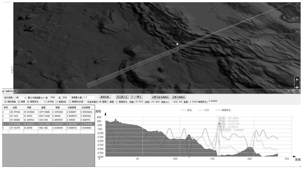
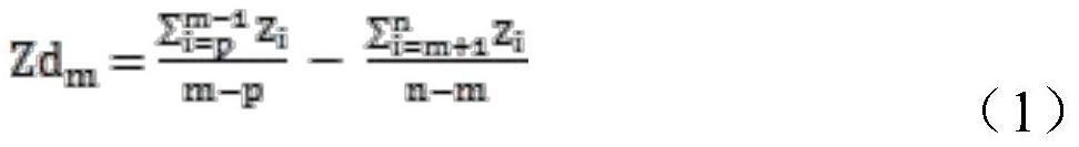
[0040] Such as figure 2 As shown in , the upper part is the window of the 3D terrain platform, and the lower part of the window is the profile analysis window; the green line segment in the 3D terrain platform is the drawn control line, and the yellow ball is the point corresponding to the selected point on the profile map in the 3D terrain The logo in the figure; the right drawing area in the analysis window is the profile analysis curve, the blue represents the elevation, the yellow represents the slope curve, and the red represents the slope change curve, and the list on the left shows the optional foot point information that meets the conditions.

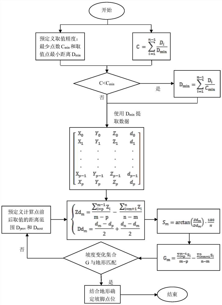
[0041] The method for determining the slope foot of the continental margin continental slope of the present invention comprises the following steps:

[0042] 1. Draw the control line of the toe point from the three-dimensional topographic map, such as figure 2 From the green line segment from land to sea in , extract profile da...


PUM


Abstract

The present invention adopts a method for determining the slope toe of the continental margin continental slope, comprising: step 1, determining the profile elevation and distance data of the slope foot point control line; step 2, according to the profile elevation of the slope foot point control line generated in step 1 and distance data to calculate the slope and slope change of the toe point control line; step 3, the determination of the toe point: select one of the points with the largest slope change that meets the toe point selection criteria as the toe point on the toe point control line ; Step 4, loop step 1-3, find the toe points on the control line of each toe point, and connect the toe points in turn to form the toe line of the continental margin continental slope. Compared with the traditional method for determining the toe point of the slope, the present invention has the following advantages: the method of the present invention makes the selection of the toe point of the continental margin intuitive and convenient, and it is easier to combine professional knowledge on the basis of calculation data to determine more accurately The location of the toe point.

Description

technical field [0001] The present invention belongs to the demarcation technology of the continental shelf beyond 200 nautical miles. In the absence of contrary proof, the method can fully combine the professional judgment of topography to determine the foot of the continental slope and delineate the outer edge of the continental edge. Background technique [0002] According to the 1982 "United Nations Convention on the Law of the Sea", it stipulates the national territorial sea, exclusive economic zone and archipelagic waters of coastal states and the scope of national sovereignty or jurisdiction. Paragraph 4 of Article 76 of the Convention stipulates the definition and scope of application of the toe point. In order to determine whether and how to apply Article 76, this requires the coastal state to identify its coastline and Features off the coast. The determination and accuracy of the slope foot point will directly affect the demarcation result. [0003] In the proces...

Claims


Application Information

Patent Timeline
Patent Type & Authority Patents(China)
IPC IPC(8): G01C9/00G01C7/02G01C15/00
CPCG01C9/00G01C7/02G01C15/00
Inventor 唐勇李家彪方银霞贾达吉吕孝辉
Owner SECOND INST OF OCEANOGRAPHY MNR
Why Eureka
Try Eureka