Method for processing and issuing remote sensing image data

A data processing and remote sensing image technology, applied in the field of remote sensing images, can solve the problems of rapid release of remote sensing data processing results without integrated processing and publishing methods, and achieve the effects of increasing speed, improving flexibility, and reducing load pressure

Active Publication Date: 2011-04-06
NONGXIN TECH BEIJING CO LTD
View PDF0 Cites 1 Cited by
  • Summary
  • Abstract
  • Description
  • Claims
  • Application Information

AI Technical Summary

Problems solved by technology

[0005] However, there is currently no efficient integrated processing and publishing method that can quickly release remote sensing data processing results

Method used


Image

  • Method for processing and issuing remote sensing image data
  • Method for processing and issuing remote sensing image data
  • Method for processing and issuing remote sensing image data

Examples


Embodiment 1

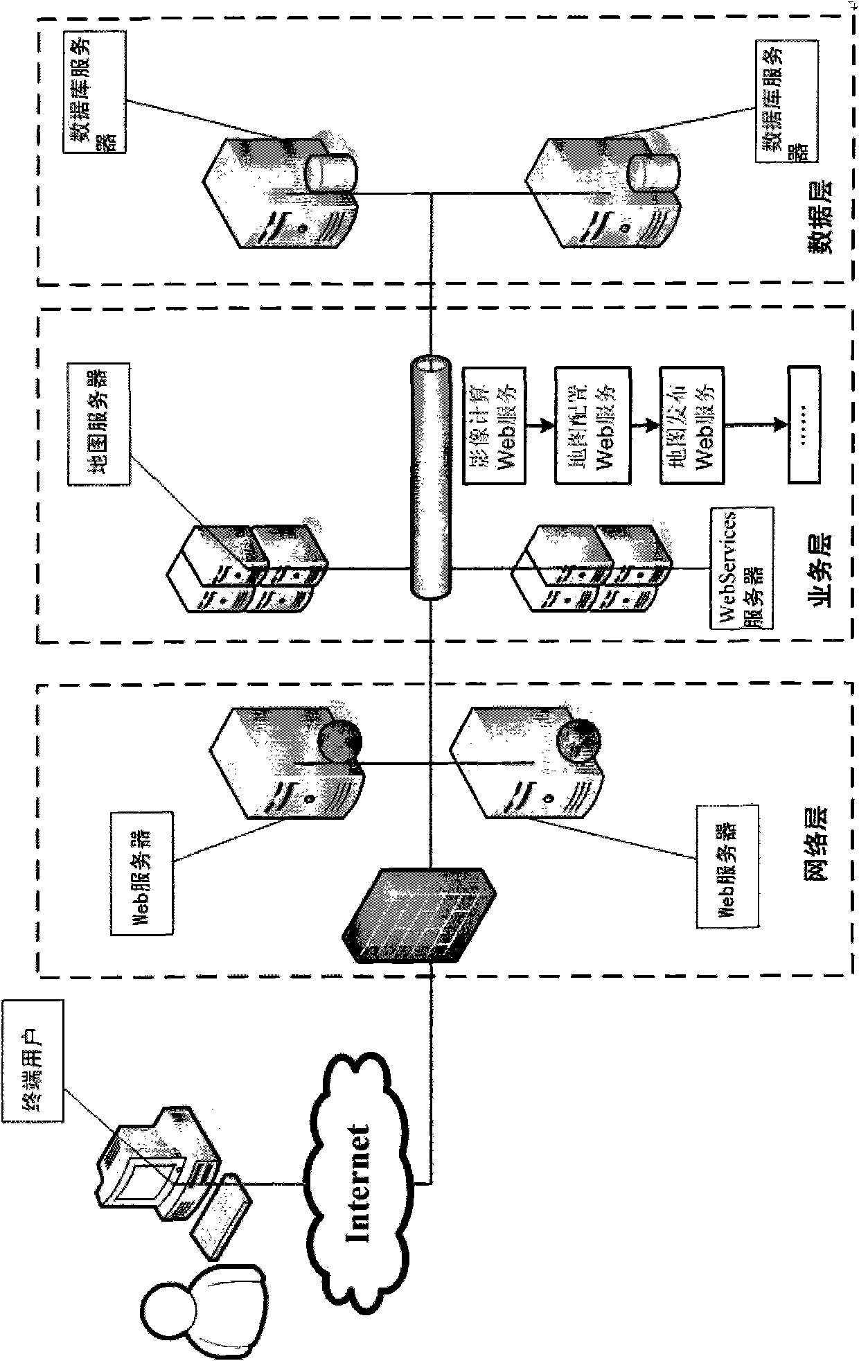
[0023] In this embodiment, when realizing the request from the server to the client, that is, when the client calls the application program on the server, the specific method adopted is to use the interactive data IDL language to process the remote sensing data on the server in advance and write the map service configuration file The method of publishing the processing result as a map service, and the map server generating a map image according to the map service is packaged into multiple Web Services by functions, which are called by client scripts; when the client calls, the server obtains the corresponding request. In principle, the problem of Web publishing of image maps is realized.

[0024] On the surface, a Web service is an application program that exposes an API that can be called through the Web to the outside world. That is to say, the application can be invoked through the Web programmatically. The application that calls this Web service is called the client.

[...

Embodiment 2

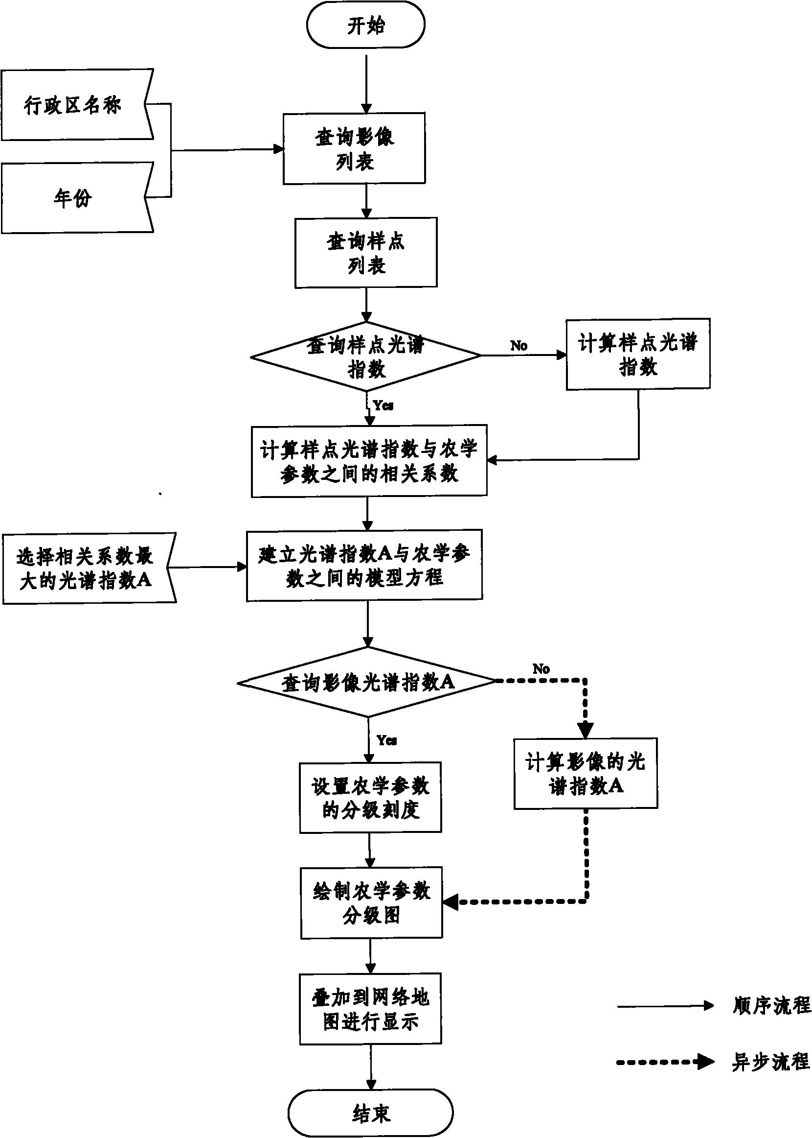
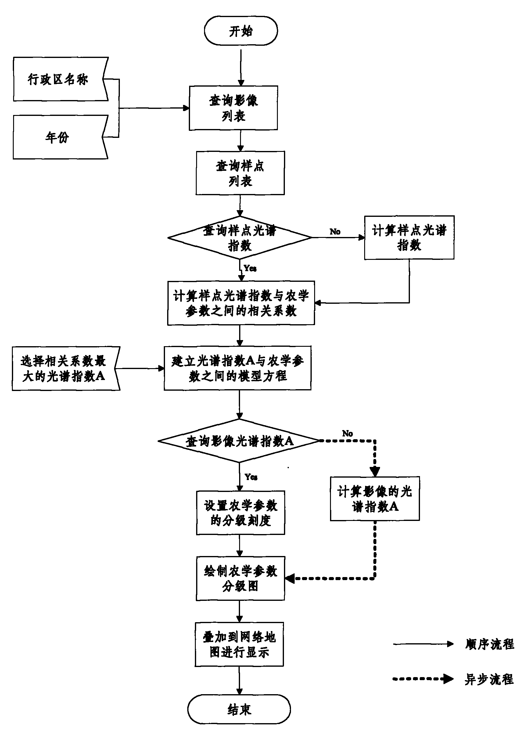
[0041] Such as figure 2 As shown, the method for processing and distributing remote sensing image data in this embodiment includes the following steps: saving the preprocessed images such as geometric correction and radiation correction to the database server on the server side; selecting a certain business type by the client through the network (such as crop growth monitoring) images are analyzed; the user can obtain the list of remote sensing images of the corresponding areas saved in the database by selecting the analysis area and time query;

[0042] The user selects one of the remote sensing images and sends a request to calculate the spectral index of the image sample point. If the image sample point index has been calculated in advance, the request is automatically exited; otherwise, the server-side sample point spectral index calculation service is called to calculate the image sample point index. spectral index;

[0043] The user selects the agronomic parameters tha...


PUM


Abstract

The invention relates to a method for processing and issuing remote sensing image data. The method comprises the following steps: S1, obtaining a request of a client in a real-time manner, automatically processing remote sensing data by a background of a server side according to the type of the request, simultaneously compiling a map service configuration file, issuing the processing result as map service, using a map server to generate a map picture according to the map service and issuing to the server side; and S2, utilizing a public network map to generate an image map according to the generated map picture and displaying the image map. The method can automatically process the image data, configure the map service file and issue the map service at the background of the server side according to the selection of a user and automatically overlap an image index to the public network map and the like at a client side for working, thereby realizing the real-time issuance of the image map and realizing that the final user can conveniently obtain the final result in a shortest time.

Description

technical field [0001] The invention relates to the technical field of remote sensing images, in particular to a method for processing and publishing remote sensing image data. Background technique [0002] With the deepening of the application of remote sensing technology in various fields, the demand for online processing of remote sensing image data and real-time release of processing results to the network is becoming stronger and stronger. [0003] Traditional remote sensing data processing usually relies on professional image processing software, and the operation method is usually manual or artificially assisted. For example, image preprocessing, image classification, index calculation, plot area statistics, etc. need to use professional software for manual processing. , and the processing results are usually image files such as thematic maps and statistical maps. To publish them on the Internet, you need to use map configuration tools to modify, update, and release m...

Claims


Application Information

Patent Timeline
Patent Type & Authority Patents(China)
IPC IPC(8): G01S7/48H04L29/08
Inventor 赵春江杨小冬王纪华黄文江李存军徐新刚宋晓宇顾晓鹤杨贵军杨浩
Owner NONGXIN TECH BEIJING CO LTD
Why Eureka
Try Eureka