Method for monitoring roadbed subsidence of express way by InSAR

A technology for highways and pavements, applied in the directions of measuring devices, radio wave measuring systems, radio wave reflection/reradiation, etc., can solve the problem of not being able to give the change trend of the entire area, the stability of benchmark points, and consuming a lot of manpower and material resources And other issues

Inactive Publication Date: 2010-05-12
CENT SOUTH UNIV
View PDF0 Cites 56 Cited by
  • Summary
  • Abstract
  • Description
  • Claims
  • Application Information

AI Technical Summary

Problems solved by technology

[0014] Although InSAR technology has been studied for monitoring large-scale surface settlement, there are few researches on the target settlement monitoring of expressway pavement, because InSAR technology itself is a surface-based processing method, which is used to monitor linear strips. There are many core algorithms that need breakthroughs for narrow-band targets. At present, the highway subsidence monitoring methods are mainly leveling survey and GPS survey, but they all have some defects: ① the stability of benchmarking points ...

Method used


Image

  • Method for monitoring roadbed subsidence of express way by InSAR
  • Method for monitoring roadbed subsidence of express way by InSAR
  • Method for monitoring roadbed subsidence of express way by InSAR

Examples


Embodiment 1

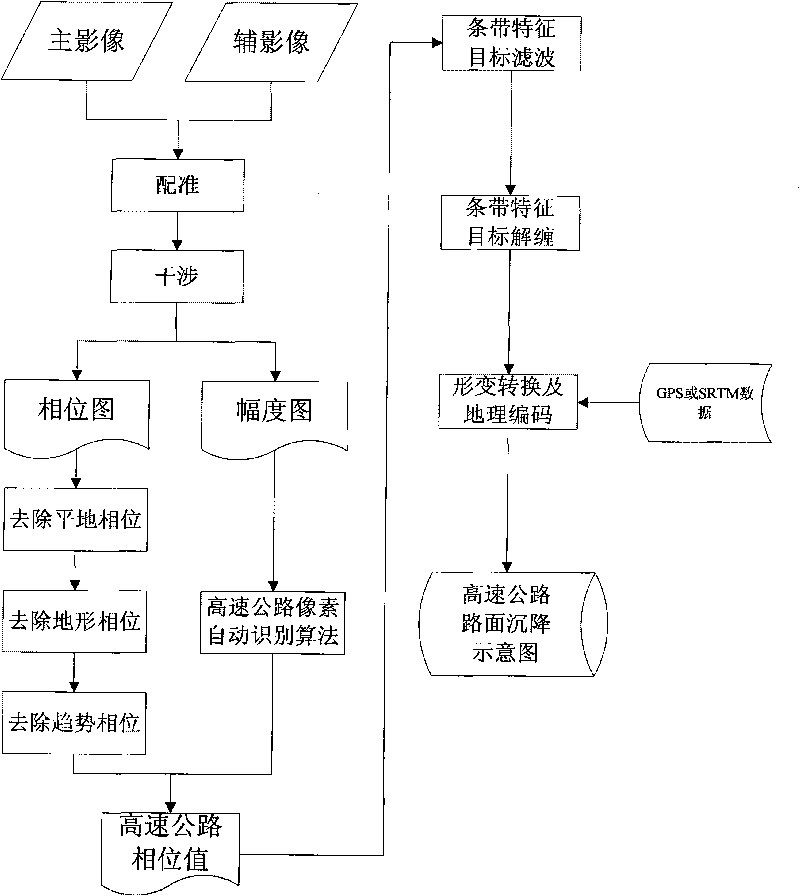
[0050] The specific embodiment of the present invention comprises the following steps:

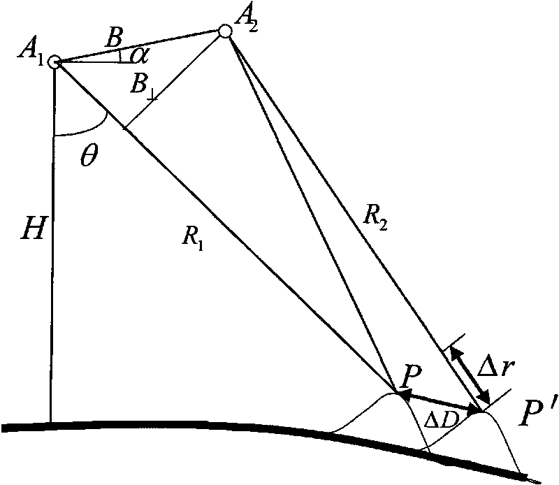
[0051] (1) Data selection and preprocessing. Customize the SAR raw image according to the coordinate range of the monitoring area. The following factors should be considered when selecting the SAR image: sensor characteristics (including wavelength, bandwidth, SNR, orbit and repetition period, etc.), data availability, time and space baseline, ground characteristics and atmosphere etc. Then preprocess the selected raw images and convert them into single-view complex images (SLC).

[0052] (2) Primary and secondary SAR image registration. The accuracy of SAR image registration directly affects the subsequent processing and the quality of the final result. To generate high-quality interference fringe images, the registration accuracy should be better than 0.2 pixels. Generally, satellite orbit information is used for coarse registration first, so that the registration accuracy can reach b...


PUM


Abstract

The invention relates to the field of geodetic survey based on remote sensing images, in particular to a method for monitoring roadbed subsidence of express way by an InSAR, which comprises the following steps of: firstly, preprocessing, rectifying and interfering SAR data to obtain an InSAR interfered phase and amplitude image; secondly, carrying out flat earth effect, orographic effect and track residual trend phase elimination on the InSAR interfered phase to obtain a phase value only including surface deformation information; thirdly, recognizing positions and coordinates of strips of the express way in the SAR image by strip characteristics of the express way in the InSAR amplitude image; fourthly, extracting the phase value of the corresponding position in the interfered phase image by using the coordinates, and restoring a real phase value by adopting a filtering and unwrapping algorithm of a strip characteristic target; and fifthly, carrying out geocoding and deformation value transformation on the real phase value to obtain a roadbed subsidence value of the express way. The method has the advantages of simple implementation, low expense, high monitoring precision, large monitoring range, high automation degree and the like.

Description

technical field [0001] The invention belongs to the field of geodetic surveying based on remote sensing images, and relates to a method for monitoring expressway road surface settlement by using InSAR (Synthetic Aperture Radar Interferometry) technology. technical background [0002] As an all-weather, large-scale, high-precision geodetic technology, Synthetic Aperture Radar Interferometry (InSAR-Interferometric Synthetic Aperture radar) has always been one of the hot topics at home and abroad in recent years. With the great abundance of SAR data, this technology has achieved unprecedented development and application, such as monitoring the surface deformation caused by groundwater extraction, coal mining, oil extraction, underground railway construction, reclamation, etc. [0003] The most basic principle of InSAR technology is to use two or more SAR images covering the same area, use the phase information contained in the SAR images to extract the distance between the rada...

Claims


Application Information

Patent Timeline
IPC IPC(8): G01S13/90G01S7/41
Inventor 朱建军胡俊丁晓利李志伟
Owner CENT SOUTH UNIV
Why Eureka
Try Eureka