Method for checking reality of ocean color remote sensing product

A technology for authenticity testing and remote sensing products, applied in the field of remote sensing, it can solve problems such as insufficient physical mechanism and data smoothing technology.

Inactive Publication Date: 2013-04-03
HANGZHOU NORMAL UNIVERSITY
View PDF2 Cites 33 Cited by
  • Summary
  • Abstract
  • Description
  • Claims
  • Application Information

AI Technical Summary

Problems solved by technology

Common filtering algorithms (such as moving average filtering, Savitzky-Golay filtering, Loess filtering, etc. [6,7] ) are generally some data smoothing techniques that consider the nature of the correlation between data but the physical mechanism is not clear enough

Method used


Image

  • Method for checking reality of ocean color remote sensing product
  • Method for checking reality of ocean color remote sensing product
  • Method for checking reality of ocean color remote sensing product

Examples


Embodiment Construction

[0105] The present invention will be further described below in conjunction with accompanying drawing.

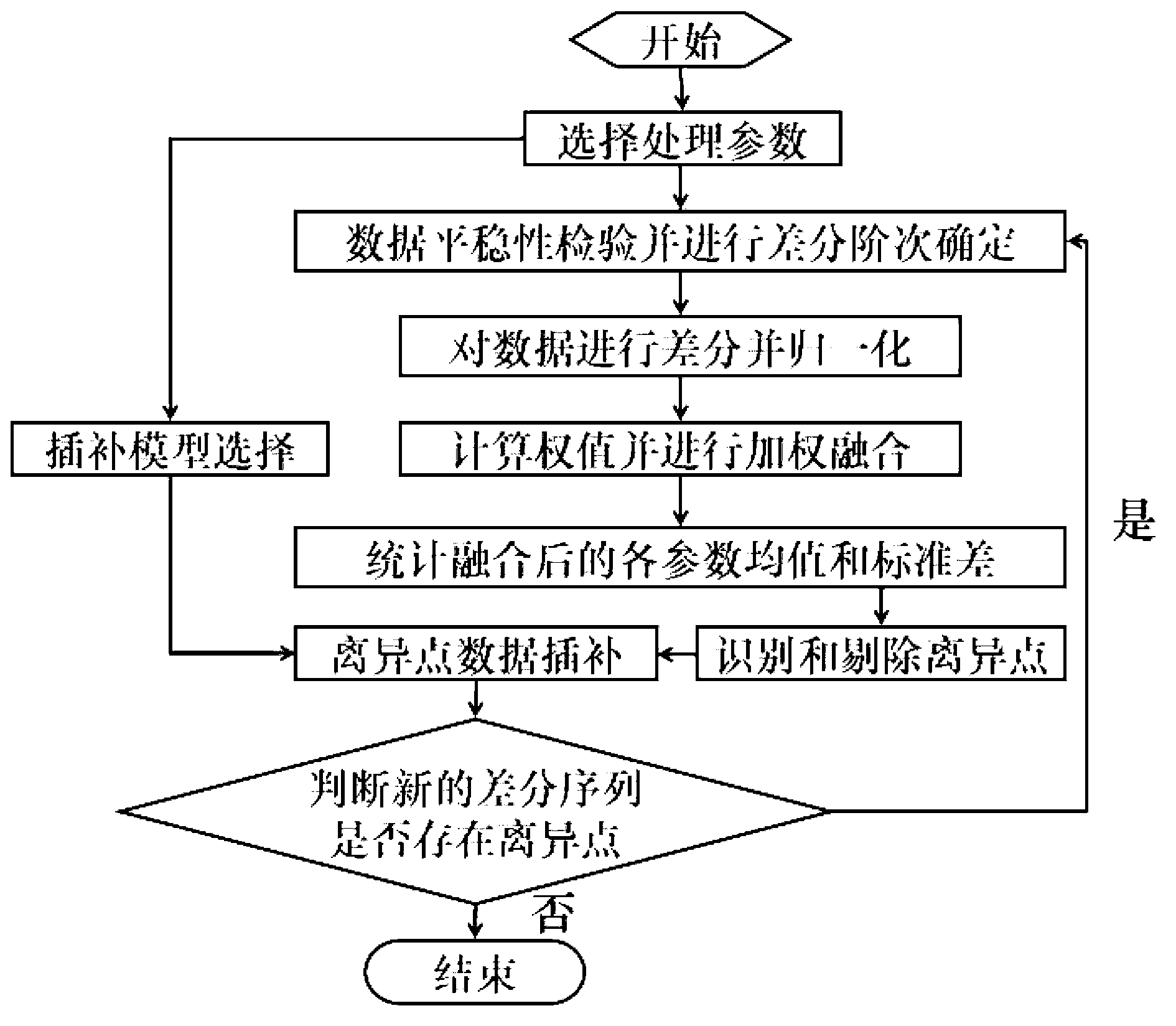
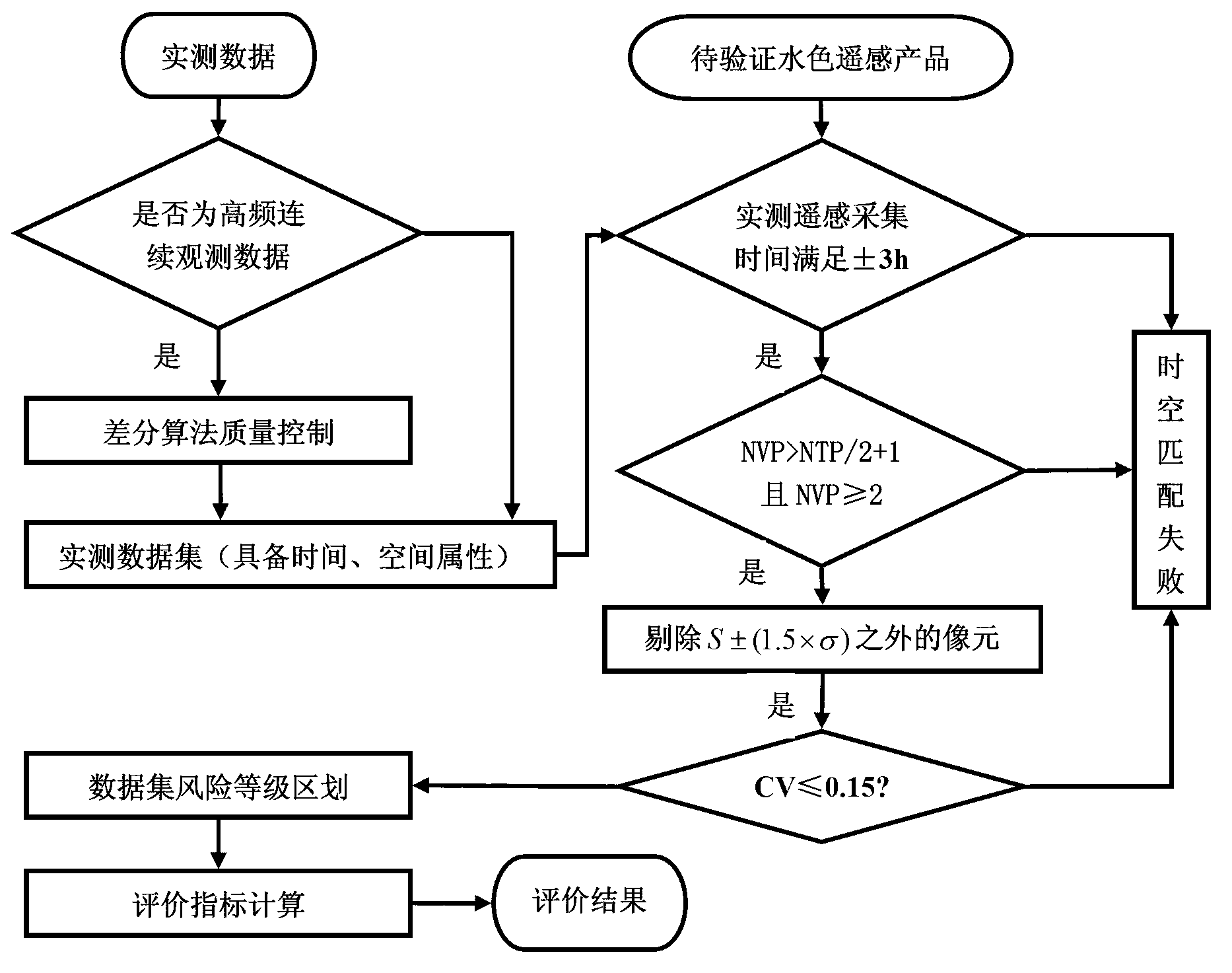
[0106] like figure 1 , figure 2 As shown, a method for authenticity testing of marine water color remote sensing products specifically includes the following steps:

[0107] Step (1). Reconstruction of long-time series remote sensing data sets;

[0108] Step (2). Calculation and synthesis of temporal-spatial variation features based on remote sensing datasets;

[0109] Step (3). Quality control and screening of measured data sets for testing remote sensing products;

[0110] Step (4). The actual measurement-remote sensing data inspection data set generation based on the spatio-temporal matching rule;

[0111] Step (5). Eligible matching data set risk level division;

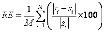
[0112] Step (6). Index calculation for authenticity inspection of remote sensing product data.

[0113] The reconstruction of the long-time series remote sensing data set in the step (1) is realiz...


PUM


Abstract

The invention discloses a method for checking the reality of an ocean color remote sensing product. The method comprises the following steps: (1) reconstructing a long time sequence remote sensing data set; (2) computing and integrating based on the time-space variation characteristics of the remote sensing data set; (3) carrying out quality control and screening on a practical measurement data set for checking the remote sensing product; (4) checking generation of data sets by practical measurement-remote sensing data based on a time-space matching rule; (5) carrying out risk level division on the eligible matched data sets; and (6) computing indexes for checking the data reality of the remote sensing product. According to the method, the representativeness and the reasonability between the remote sensing product data and the checking practical measurement data can be checked, the matched data sets are screened and generated, and an evaluation method for different risk levels is obtained, so that the evaluation results are diversified and reasonable, the uncertain risk in the checking process is lowered, and the checking credibility is improved.

Description

technical field [0001] The invention belongs to the technical field of remote sensing, and in particular relates to a method for authenticity testing of marine water color remote sensing products, especially for the practical problem of uncertain test results caused by time and space variation. Background technique [0002] Since the first water color satellite sensor CZCS (Coastal Zone Color Scanner) was put into use in October 1978, the number, spectral channel, radiation performance, and spatial resolution of water color satellite sensors have been greatly developed. The commercial application of numerous water color remote sensing products provides large-scale and continuous observation data for oceanographic research. However, the accuracy verification of water color remote sensing products has always been a hot spot of concern. Due to the complex temporal and spatial variability of the ocean surface, there are still many controversial issues in the verification meth...

Claims


Application Information

Patent Timeline
Patent Type & Authority Applications(China)
IPC IPC(8): G06F19/00
Inventor 周斌蒋锦刚窦文洁于之锋
Owner HANGZHOU NORMAL UNIVERSITY
Why Eureka
Try Eureka