A method of continuous navigation in case of satellite signal blockage

A technology of satellite signal and navigation method, applied in satellite radio beacon positioning system, navigation, surveying and navigation and other directions, can solve the problem of not being long, unable to locate the duration of positioning, etc., and achieve the effect of reducing the deterioration of positioning accuracy

CN103675880BActive Publication Date: 2016-01-13SPACE STAR TECH CO LTD
3 Cites 0 Cited by

Patent Information

Authority / Receiving Office
CN · China
Patent Type
Patents(China)
Current Assignee / Owner
Publication Date
2016-01-13

Smart Images

  • Figure 1
    Figure 1
  • Figure 2
    Figure 2
  • Figure 3
    Figure 3
Patent Text Reader

Abstract

The invention discloses a continuous navigation method implemented under a satellite signal blocking condition. Satellite signal blocking refers to the fact that the quantity of visible satellites is lower than 4. The continuous navigation method includes a step of (1), creating a navigation calculation state equation, in other words, selecting positions, speeds and accelerations of users in three axial directions as state parameters, creating user movement models, combining the user movement models with clock modules to obtained combinations, and discretizing the combinations to obtain the state equations. The continuous navigation method has the advantage that different continuous navigation solutions can be respectively provided for the high-dynamic and low-dynamic users under the condition that the quantity of the satellites is lower than 4.
Need to check novelty before this filing date? Find Prior Art

Description

technical field

[0001] The invention proposes a continuous navigation method in the case of satellite signal blockage, which is mainly applied to continuous positioning in the case of satellite signal blockage. Background technique

[0002] Among the satellite navigation and positioning algorithms, the most common algorithm is the least squares or weighted least squares method. These two algorithms cannot be positioned in the case of signal blockage, and the positioning results are usually rough and messy in the case of non-blocking. When satellite navigation equipment is used in civil aviation, drones and missiles, these unfixed and jumping points may have unpredictable effects on users. In the existing satellite navigation and positioning algorithms, the LS and WLS methods can seek an optimal point among the observations containing errors and noises, so that the residual sum of squares of the observations is the smallest, but due to the measurement errors and noise solutio...

Examples

Embodiment Construction

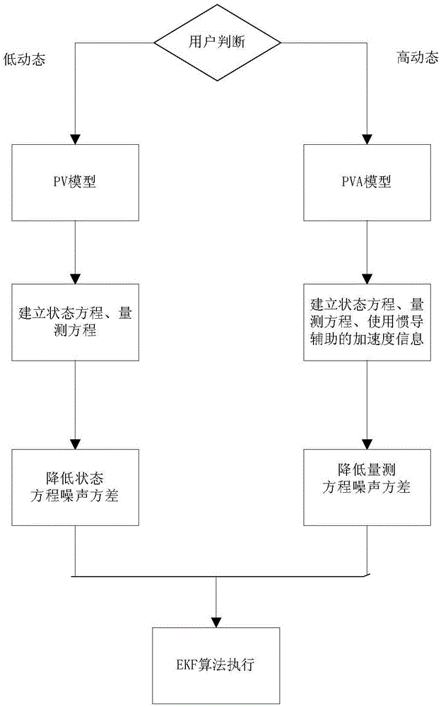
[0155] A continuous navigation method in the case of satellite signal blockage, where the satellite signal blockage means that the number of visible satellites will be less than 4, such as figure 1 As shown, the implementation steps are as follows:

[0156] (1) Establish the navigation solution state equation, select the position, velocity and acceleration of the user's three-axis direction as the state quantity and establish the user motion model, and combine the user motion model and the clock model together and discretize it as the state equation; the details are as follows

[0157] ①Carrier motion model

[0158] Using the Singer model as the carrier motion model, assuming the sampling period is T, the discretized carrier motion model is:

[0159] x u (k)=Φ u (k,k-1)X u (k-1)+W u (k-1) (Equation 1)

[0160] In the formula

[0161] Φ u ( k , k - 1 ...