
Forest fire prevention control system based on Beidou/GPS and GIS integrated application
A forest fire prevention and control system technology, which is applied in the direction of comprehensive factory control, electrical program control, climate change adaptation, etc., can solve problems such as poor communication, communication interruption, etc., to increase positioning accuracy, avoid communication blind spots, and facilitate communication guarantee services. Effect
- Summary
- Abstract
- Description
- Claims
- Application Information
AI Technical Summary
Problems solved by technology
Method used
Image

Examples
Embodiment Construction
[0013] The technical solutions of the present invention will be described in further detail below with reference to the accompanying drawings and embodiments.
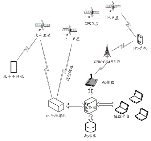
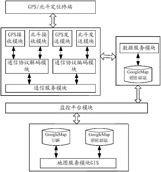
[0014] figure 1 It is a network architecture diagram of a forest fire prevention control system based on Beidou / GPS and GIS integrated application according to an embodiment of the present invention.
[0015] Such as figure 1 As shown, the system is an integrated platform of software and hardware integrated with GIS, GNSS and GPRS realized on the Internet. It consists of four parts: satellite positioning and navigation system, positioning terminal, monitoring and command center, and communication link.
[0016] The satellite positioning and navigation system is composed of GPS and Beidou satellite navigation system. GPS is a satellite navigation system proposed by the United States in the 1960s and fully built in 1993. It has been widely used in various industries. The Beidou satellite navigation system is a regiona...
PUM
 Abstract
Description
Claims
Application Information