High-precision satellite MODIS (Moderate-resolution Imaging Spectroradiometer) monitoring method for chlorophyll a of eutrophic lake water body

A eutrophication and chlorophyll technology, applied in the measurement of color/spectral characteristics, etc., can solve the problem of lack of more reliable atmospheric correction methods, and achieve the effect of effectively evaluating performance

Active Publication Date: 2015-03-04
NANJING INST OF GEOGRAPHY & LIMNOLOGY
View PDF7 Cites 22 Cited by
  • Summary
  • Abstract
  • Description
  • Claims
  • Application Information

AI Technical Summary

Problems solved by technology

First, the existing MODIS Chla algorithm (such as OC2, OC3, OC4 and OCI, etc.) is not suitable for highly turbid eutrophic water; The water area is saturated, and there is almost no data available. Therefore, we can only use the unsaturated land wide-band algorithm to invert Chla; finally, there is currently no reliable atmospheric correction method to help MODIS obtain the Rrs data of inland turbid lakes (full and accurate atmospherically corrected data)

Method used


Image

  • High-precision satellite MODIS (Moderate-resolution Imaging Spectroradiometer) monitoring method for chlorophyll a of eutrophic lake water body
  • High-precision satellite MODIS (Moderate-resolution Imaging Spectroradiometer) monitoring method for chlorophyll a of eutrophic lake water body
  • High-precision satellite MODIS (Moderate-resolution Imaging Spectroradiometer) monitoring method for chlorophyll a of eutrophic lake water body

Examples


Embodiment Construction

[0082] In order to better understand the technical content of the present invention, specific embodiments are given together with the attached drawings for description as follows.

[0083] Aspects of the invention are described in this disclosure with reference to the accompanying drawings, which show a number of illustrated embodiments. Embodiments of the present disclosure are not necessarily intended to include all aspects of the invention. It should be understood that the various concepts and embodiments described above, as well as those concepts and embodiments described in more detail below, can be implemented in any of a number of ways, which should be the concepts and embodiments disclosed by the present invention and not Not limited to any implementation. In addition, some aspects of the present disclosure may be used alone or in any suitable combination with other aspects of the present disclosure.

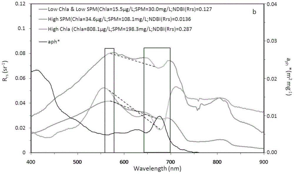
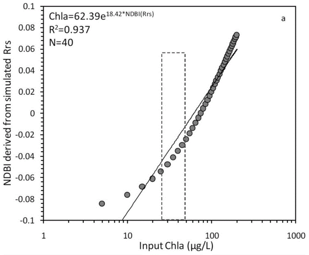
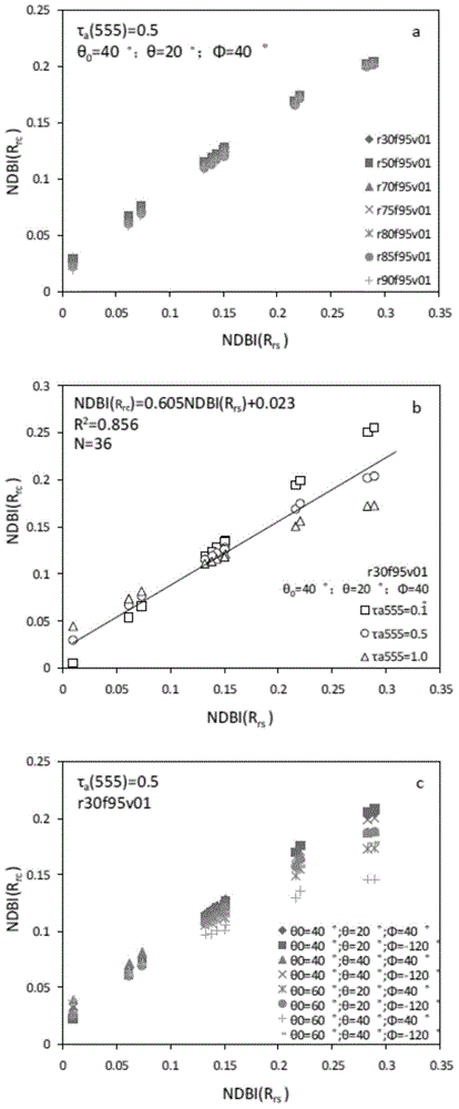
[0084] The present invention uses MODIS satellite data to monitor...


PUM


Abstract

The invention provides a high-precision satellite MODIS (Moderate-resolution Imaging Spectroradiometer) monitoring method for chlorophyll a of a eutrophic lake water body. The method comprises the following steps: screening a chlorophyll a evaluation index (NDBI) which is sensitive to the concentration change of the chlorophyll a and is not influenced by high suspended solids; obtaining a quantitative relation between the NDBI and the concentration of the chlorophyll a on the basis of biological optical model simulation; combining spectral information of the water body and the corresponding concentration of the chlorophyll a of the water body monitored in the field in Chaohu Lake in year 2013-2014, so as to obtain a chlorophyll a inversion algorithm based on a ground measured spectrum (Rrs) and the NDBI; simulating different aerosol types and thicknesses, different solar altitudes, satellite observation angles and azimuth angles, so as to obtain a quantitative relation between the ground monitored remote sensing reflectance (Rrs) and simulated Rrc subjected to Rayleigh scattering correction; and further extending the chlorophyll a inversion algorithm based on ground measured spectral data to satellite image data subjected to the Rayleigh scattering correction. According to the method, the inter-annual and inter-monthly change rules and space distribution of the rules of the concentration of the chlorophyll a of a eutrophic lake can be accurately obtained.

Description

technical field [0001] The invention relates to a MODIS satellite high-precision monitoring method for chlorophyll-a in eutrophic lake water. Background technique [0002] Remote sensing technology is widely used to monitor water eutrophication and algal blooms, which has greatly improved the real-time monitoring ability of water quality (Matthews, 2010; Odermatt et al., 2012). Chlorophyll a (Chla, μg / L) is an important indicator of algal bloom intensity and water nutrient status, and has become the most common parameter in water quality remote sensing (Chaeffer et al., 2012; Matthews, 2010; Qi et al., 2014). In recent years, due to the frequent occurrence of algal blooms, there has been a serious threat to the quality of drinking water and irrigation water (Duan et al., 2009; Guo, 2007), and the use of remote sensing to monitor water body chlorophyll a has quickly become a research hotspot (Paerl & Huisman, 2008; Paerl & Huisman, 2009; Matthews, 2010; Odermatt et al., 2012...

Claims


Application Information

Patent Timeline
Patent Type & Authority Applications(China)
IPC IPC(8): G01N21/25
Inventor 张玉超马荣华段洪涛陈开宁
Owner NANJING INST OF GEOGRAPHY & LIMNOLOGY
Why Eureka
Try Eureka