Multi-angle unmanned aerial survey system

A multi-angle, unmanned aerial vehicle technology, applied in the field of aerial photography, can solve the problems of inability to truly reflect the actual situation of ground objects, high cost of 3D modeling work, and high labor and material resources, so as to reduce work costs and implementation costs. , the effect of reducing labor intensity

Inactive Publication Date: 2015-09-02
XIAN UNIV OF SCI & TECH
View PDF6 Cites 62 Cited by
  • Summary
  • Abstract
  • Description
  • Claims
  • Application Information

AI Technical Summary

Problems solved by technology

[0004] The purpose of the present invention is to provide a multi-angle unmanned aerial survey system, which aims to solve the problem of establishing a 3D model by taking pictures on ...

Method used


Image

  • Multi-angle unmanned aerial survey system
  • Multi-angle unmanned aerial survey system
  • Multi-angle unmanned aerial survey system

Examples


Embodiment Construction

[0042] In order to make the object, technical solution and advantages of the present invention more clear, the present invention will be further described in detail below in conjunction with the examples. It should be understood that the specific embodiments described here are only used to explain the present invention, not to limit the present invention.

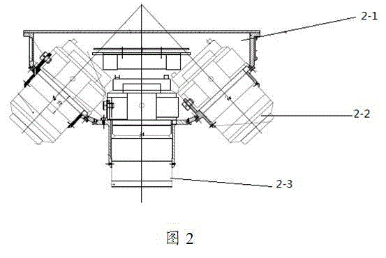
[0043] The present invention is equipped with a five-lens tilt camera, which can obtain the texture of each side of the ground building, and automatically and quickly create a large-scale digital city model based on a dense matching algorithm. Modeling Manual modeling, compared with traditional 3D modeling methods, saves a lot of manpower and material resources, and meets the requirements of large-scale digital city models.

[0044] The application principle of the present invention will be described in detail below in conjunction with the accompanying drawings.

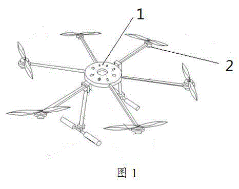
[0045] Such as figure 1 As shown, the multi-angle unmanned...


PUM


Abstract

The invention discloses a multi-angle unmanned aerial survey system. The multi-angle unmanned aerial survey system is provided with a six-rotor-wing unmanned aerial vehicle, and each multi-view-angle inclined camera composed of five camera lenses is carried on the six-rotor-wing unmanned aerial vehicle. Each multi-view-angle inclined camera comprises a shooting unit, a controlling unit and a hanging unit. The six-rotor-wing unmanned aerial vehicle comprises an unmanned aerial vehicle flying platform system, a GPS, a flying controlling system, a remote sensing shooting system, a ground controlling system and a signal transmitting system. Ground images can be collected at the same time at multiple angles, in this way, the defect that according to a traditional aerial photography technology, shooting can be performed only at a vertical angle is overcome, the actual conditions of a ground feature can be reflected more really, and the defects in orthophotography are overcome; through integrating POS data, DSM data, vectors and others, a three-dimensional model establishing technology based on image intensive matching is established, a digital city model is rapidly and efficiently established, and therefore the working cost for three-dimensional model establishing is greatly lowered.

Description

technical field [0001] The invention belongs to the technical field of aerial photography, and in particular relates to a multi-angle unmanned aerial survey system. Background technique [0002] In January 1998, the United States put forward the concept of "Digital Earth" based on its own interests and global political, economic, and military strategic goals. More than 100 cities in China have carried out the construction of "Digital Cities". As an important part of digital city construction, 3D modeling of digital cities has also developed rapidly. At present, most of the areas where digital cities are built have carried out a lot of 3D modeling work, but 3D modeling work is costly, slow, and consumes a lot of manpower. and physical resources. In recent years, the field of international geographic information has combined traditional aerial photography technology and digital ground acquisition technology to develop a high-tech called airborne multi-angle oblique photograph...

Claims


Application Information

Patent Timeline
IPC IPC(8): G01C11/00
CPCG01C11/00
Inventor 赵国梁
Owner XIAN UNIV OF SCI & TECH
Why Eureka
Try Eureka