Residential area route map forming system and method based on crowd sensing network

A swarm perception and path technology, which is used in services based on location information, road network navigators, electrical components, etc. It can solve the problem that the positioning accuracy cannot meet the actual application, the road access is limited, and the path of the cell cannot be explored in depth, etc. question

Active Publication Date: 2016-09-28
GUANGDONG UNIV OF TECH
View PDF6 Cites 9 Cited by
  • Summary
  • Abstract
  • Description
  • Claims
  • Application Information

AI Technical Summary

Problems solved by technology

In an open outdoor environment, the global positioning system and cellular wireless communication system provide more accurate and reliable location information. Influenced by factors such as the effect, the positioning accu

Method used


Image

  • Residential area route map forming system and method based on crowd sensing network
  • Residential area route map forming system and method based on crowd sensing network
  • Residential area route map forming system and method based on crowd sensing network

Examples


Example Embodiment

[0082] The present invention will be described in detail below in conjunction with examples.
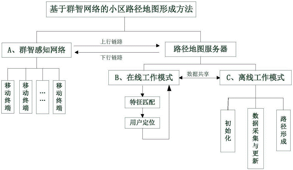
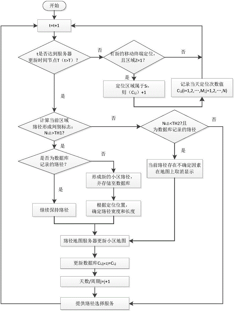
[0083] Such as figure 1 It is the overall block diagram of the method of forming the path map of the community based on the group intelligence perception network. The overall block diagram includes group intelligence perception network and route map server. Among them, the group intelligence perception network includes two service links for data interaction with the route map server, and the route map server includes an online working mode and an offline working mode.

[0084] The two service links included in the swarm intelligence network are uplink and downlink. When many users enter the target cell to use the location service, the Qunzhi Awareness Network uploads the location information of the user’s mobile terminal and the collected information tags from the uplink to the route map server through the Qunzhi Network after the user’s authorization, and obtains the current For locat...


PUM


Abstract

The invention relates to application of a wireless network, and provides a residential area route map forming method based on a crowd sensing network. The method mainly comprises the crowd sensing network and a route map server. The crowd sensing network comprises an up service link and a down service link which carry out data interaction with the route map server. The route map server comprises an online working mode and an offline working mode. The online working mode comprises two working processes of feature matching and user positioning. The offline working mode comprises three parts of initialization, data collection and update and route formation. According to the residential area route map forming method based on the crowd sensing network provided by the invention, a method for periodically increasing, keeping and deleting residential area map routes is established. Under the condition that there is no GPS signal, the current route map of a residential area is periodically updated by use of wireless signals of a wireless access point; a user can know the route map and walking path of the currently located residential area through the mobile terminal; and the travel efficiency of the user can be effectively improved.

Description

technical field [0001] The invention relates to the application of a wireless network, mainly outdoor positioning technology, and in particular to a system and method for forming a community route map based on a crowd sensing network. Background technique [0002] With the development of society, our country proposes to promote the block system for new residential buildings, and in principle no closed residential quarters will be built. The completed residential quarters and unit compound should be gradually opened up to realize the publicization of internal roads, solve the problem of traffic road network layout, and promote the economical use of land. The purpose of building an open community is to open up the roads in the community, relieve traffic pressure, and improve people's travel efficiency. In the process of publicizing the roads in the community that has been built for many years, because people in the society are not familiar with the distribution and direction ...

Claims


Application Information

Patent Timeline
IPC IPC(8): H04W64/00H04W4/02G01C21/34
Inventor 刘震宇李嘉俊曹璐
Owner GUANGDONG UNIV OF TECH
Why Eureka
Try Eureka