Coastline area remote sensing map-based satellite borne spectrograph pointing registration method

A coastline and spectrometer technology, which is applied in the field of remote sensing digital image analysis processing and spectral analysis, to achieve the effect of expanding the scope of application

Active Publication Date: 2017-04-26
HEFEI INSTITUTES OF PHYSICAL SCIENCE - CHINESE ACAD OF SCI
View PDF4 Cites 18 Cited by
  • Summary
  • Abstract
  • Description
  • Claims
  • Application Information

AI Technical Summary

Problems solved by technology

Because the spectrometer is a non-imaging optical system, the output measurement data is spectral data, so its pointing registration needs to adopt the nadir observation mode (that is, the spaceborne spectrometer observes in the sky perpendicular to the surface), using high-resolution CCD image data Point-to-point registration with its non-image spectral data, which cannot be achieved by traditional registration methods based on two identical data types such as image data

Method used


Image

  • Coastline area remote sensing map-based satellite borne spectrograph pointing registration method
  • Coastline area remote sensing map-based satellite borne spectrograph pointing registration method
  • Coastline area remote sensing map-based satellite borne spectrograph pointing registration method

Examples


Embodiment Construction

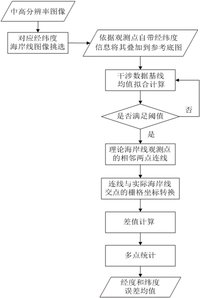
[0035] The present invention will be further described below in conjunction with the accompanying drawings and specific embodiments.

[0036] Such as figure 1 As shown, a pointing registration method of spaceborne spectrometer based on the remote sensing image of the coastline area includes the following steps:

[0037] S1. From the remote sensing images collected by remote sensing cameras such as CCD cameras, select medium and high resolution (16000*14000) remote sensing images with obvious coastline areas within a certain latitude and longitude range as the reference base map, and extract the coastline from the reference base map.

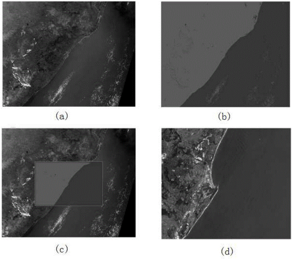
[0038] If there are large islands near the edge of the mainland coastline, it will have a greater impact on the registration algorithm, so try to avoid islands when selecting coastlines, such as figure 2 As shown in (a); using unsupervised classification, the coastline can be extracted well, and the result is as follows figure 2 as shown in (...


PUM


Abstract

The present invention provides a coastline area remote sensing map-based satellite borne spectrograph pointing registration method. According to the method, under a nadir observation mode, pointing registration is performed through using the characteristic that large-area uniform landforms exist in a special ground feature-coastline area in a high-and-middle-resolution remote sensing image and the characteristic that surface reflectance changes abruptly; the longitudes and latitudes of measurement points of a satellite borne spectrograph in an observation area are in one-to-one correspondence with the longitudes and latitudes of the pixels of a remote sensing image outputted by a remote sensing camera in a corresponding area; and the errors of the longitudes and latitudes of the measurement points and the longitudes and latitudes of the pixels are corrected, and are put into statistics and are monitored in real time. Arithmetic processing such as spectral data fitting and comparison and pixel grid geometric coordinate transformation is adopted; and a reference base map required by the pointing registration of the satellite borne spectrograph can come from other satellite loads, that is, the satellite borne spectrograph can be in non-rigid coaxial connection with the remote sensing camera, or the reference base map required by the pointing registration of the satellite borne spectrograph can come from different satellites, and thus the application range of the registration method of pointing between the non-imaging satellite spectrograph and the imaging remote sensing camera can be extended.

Description

technical field [0001] The invention relates to the technical field of remote sensing digital image analysis and processing and spectral analysis, in particular to a pointing registration method for a spaceborne spectrometer based on a remote sensing image of a coastline area. Background technique [0002] Point-to-point registration refers to the spatial transformation of two or more images acquired from the same or different sensors on the same target area at different times and from different perspectives, or images and other information sources in the same reference coordinate system. Due to the differences in data between devices of different data types and the difficulty of matching, at present, most of the research on registration at home and abroad is between devices of the same data type, and many registration algorithms are based on the matching operation between images. proposed, while there are few studies on the registration between different data types of devic...

Claims


Application Information

Patent Timeline
Patent Type & Authority Applications(China)
IPC IPC(8): G06T7/00G01J3/28
Inventor 汪俊峰崔文煜杜丽丽易维宁施海亮
Owner HEFEI INSTITUTES OF PHYSICAL SCIENCE - CHINESE ACAD OF SCI
Why Eureka
Try Eureka