A Method for Automatically Optimizing Remote Sensing Image Segmentation Parameters Based on Regional Inconsistency Evaluation

A technology for segmenting parameters and remote sensing images, which is applied in the field of earth science research, and can solve problems such as poor pertinence in the classification of ground objects, unfavorable image classification, and large scale of segmentation parameters.

Active Publication Date: 2019-05-24
LANZHOU UNIVERSITY
View PDF3 Cites 0 Cited by
  • Summary
  • Abstract
  • Description
  • Claims
  • Application Information

AI Technical Summary

Problems solved by technology

[0007] By analyzing and summarizing the optimal scale segmentation parameter selection method, it is proposed that the scale evaluation should be combined with information such as shape and texture, and finally realize the automatic selection of scale segmentation parameters. However, most of the current automatic methods are unsupervised segmentation, and there are selected segmentations to a certain extent. The parameter scale is too large, the classification of ground objects is not very targeted, and the phenomenon of under-segmentation is obvious, which will have a negative impact on subsequent image classification.

Method used


Image

  • A Method for Automatically Optimizing Remote Sensing Image Segmentation Parameters Based on Regional Inconsistency Evaluation
  • A Method for Automatically Optimizing Remote Sensing Image Segmentation Parameters Based on Regional Inconsistency Evaluation
  • A Method for Automatically Optimizing Remote Sensing Image Segmentation Parameters Based on Regional Inconsistency Evaluation

Examples


Embodiment Construction

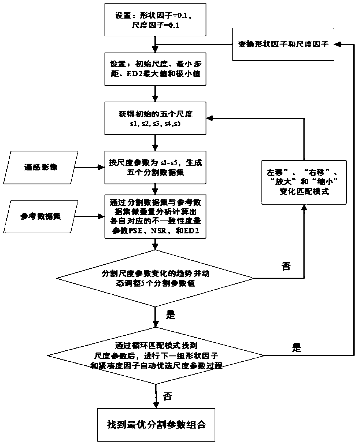
[0158] Such as image 3 As shown, it is a flowchart of a method for automatically optimizing remote sensing image segmentation parameters based on regional inconsistency evaluation in an embodiment of the present invention; in all embodiments of the present invention, step 1 has a minimum step distance d min = 1, given ED2 min Maximum value L=1.0, shape factor=0.1, compactness factor=0.1, ED2 min The minimum value ζ=0.0001.

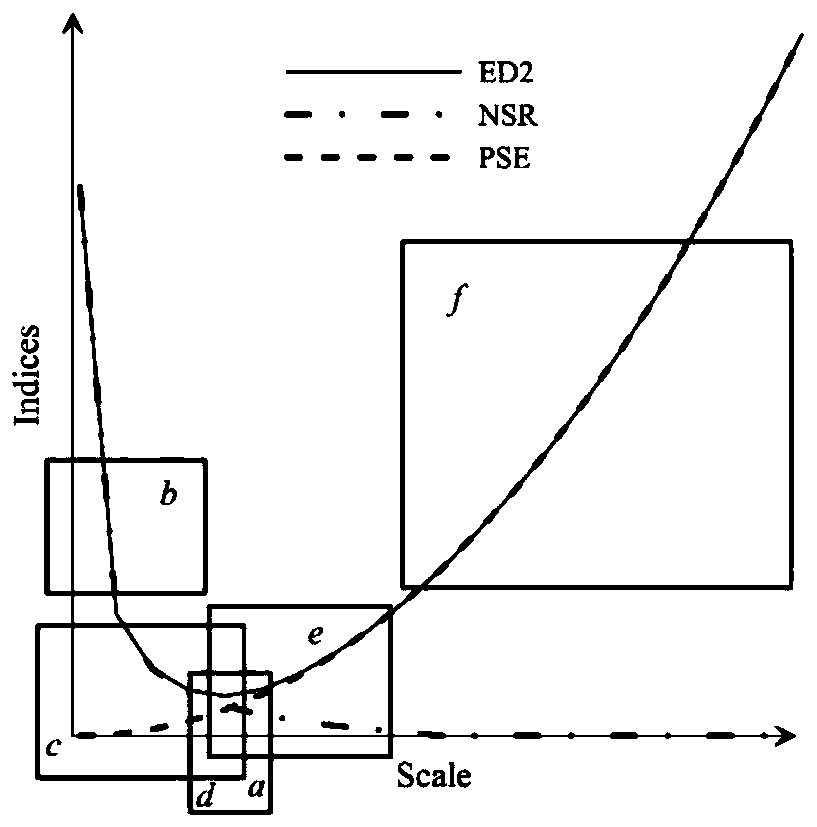
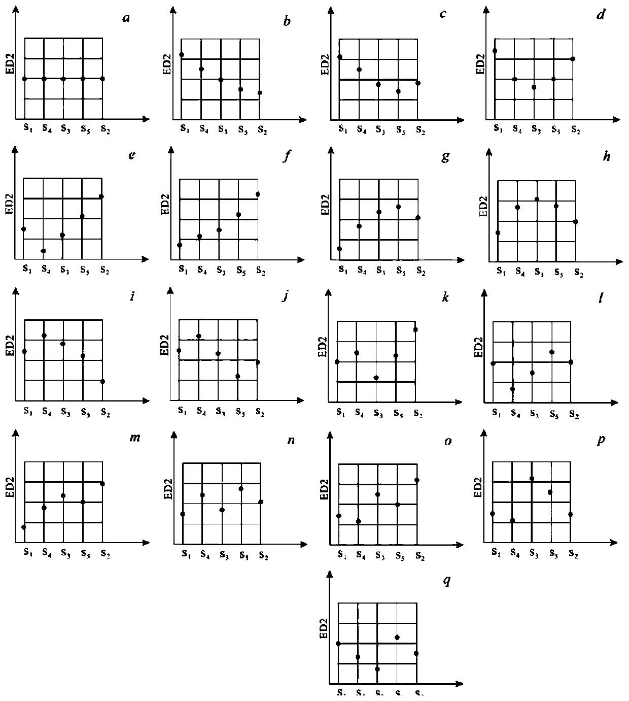
[0159] Such as figure 2 Shown is a schematic diagram of the 17 basic modes of ED2 varying with scale segmentation parameters.

[0160] 1. The comparison of the method of the present invention and the exhaustive method for selecting the optimal segmentation parameter combination

[0161] The embodiment of the present invention is applied to three different ground objects (cultivated land FL) in the multi-spectral and fused six-view high-resolution remote sensing images of three sensors (Quick bird, Alos, World view2) in Dongguan City, Guangdong Provin...


PUM


Abstract

The invention discloses a method for automatically and optimally selecting remote sensing image segmentation parameters based on regional inconsistency evaluation. A segmentation data set is constructed in turn based on five groups of equidistant scale parameters and fixed shape factors and compactness factors, then an ED2 array is obtained from the segmentation data set and a corresponding reference data set based on PSE-NSR-ED2 inconsistency segmentation parameter evaluation system, the distribution mode of the five values of the ED2 array changing along with the scale parameters is analyzed, constant iteration is performed through transformation of the five scale parameters until the minimum ED2 value of the bottom part of an oblique U-shaped ED2-SP curve is found, and the scale parameters corresponding to the minimum ED2 value are the optimal scale parameters; and finally constant iteration of the process is performed on the basis of different combinations of the shape factors and the compactness factors. Blindness of parameter selection can be avoided so that the uncertainty caused by a trial-and-error method and time consumption caused by a method of exhaustion can be solved, and the accuracy and the degree of automation of object-oriented remote sensing image processing and analysis can also be enhanced.

Description

technical field [0001] The invention belongs to the field of earth science research, and particularly relates to remote sensing geoscience space statistical analysis and pattern recognition, and in particular to a method for automatically optimizing remote sensing image segmentation parameters based on regional inconsistency evaluation. Background technique [0002] In the field of remote sensing, different image segmentation algorithms have been proposed for different applications and purposes, and the emergence of multiresolution segmentation (Multiresolution Segmentation) algorithm is considered a milestone in remote sensing image segmentation. The algorithm combines the spectral information and spatial information of the image during image segmentation, and can generate the image object with the highest internal homogeneity. Its main parameters include scale, shape factor, and compactness factor. Different combinations of these parameters will produce different Split res...

Claims


Application Information

Patent Timeline
Patent Type & Authority Patents(China)
IPC IPC(8): G06T7/10
CPCG06T2207/10032
Inventor 张寅丹刘勇王苗苗黄哲
Owner LANZHOU UNIVERSITY
Why Eureka
Try Eureka