Road longitudinal and lateral section obtaining method based on LiDAR point cloud

An acquisition method and road technology, applied in the field of surveying and mapping, can solve the problem of large amount of point cloud data that cannot be read uniformly, and achieve the effect of avoiding low efficiency

Inactive Publication Date: 2017-06-23
星际空间(天津)科技发展有限公司
View PDF5 Cites 34 Cited by
  • Summary
  • Abstract
  • Description
  • Claims
  • Application Information

AI Technical Summary

Problems solved by technology

Through the method of seamless block, it cleverly solves the problem that the large amount of point cloud data cannot be read uniformly

Method used


Image

  • Road longitudinal and lateral section obtaining method based on LiDAR point cloud
  • Road longitudinal and lateral section obtaining method based on LiDAR point cloud
  • Road longitudinal and lateral section obtaining method based on LiDAR point cloud

Examples


Embodiment 1

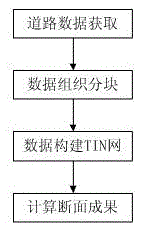
[0044] figure 1 A schematic flow diagram of a method for acquiring road longitudinal and cross-sections based on LiDAR point clouds provided in this embodiment, such as figure 1 As shown, the method includes the following steps:

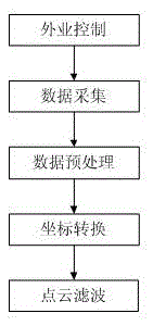
[0045] Road data acquisition: After field control, data acquisition, data preprocessing, coordinate conversion, point cloud filtering and other steps to generate filtered road ground point cloud data;

[0046] Data organization and block: manage the point cloud data in blocks according to the appropriate distance grid;

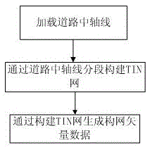
[0047] Data construction TIN network: according to the existing road central axis, construct TIN network according to a specific distance buffer;

[0048] Calculation of section results: Generate vertical and horizontal section files based on mileage files.

[0049] Such as figure 2 As shown, a method for acquiring road vertical and horizontal sections based on LiDAR point cloud, the road data acquisition: After field control, d...


PUM


Abstract

The invention discloses a road longitudinal and lateral section obtaining method based on a LiDAR point cloud, and relates to the technical field of measurement. The method comprises the following steps: road data obtaining: generating filtered road surface point cloud data through the steps of field control, data collection, data preprocessing, coordinate conversion and point cloud filtering; data organization blocking: carrying out the block management of point cloud data according to a proper distance grid; TIN network construction through data: carrying out the buffering and constructing a TIN network according to an existing road central axis and a specific distance; section accomplishment calculation: generating a longitudinal and lateral section file according to a mileage file. The method is advantageous in that the method organizes the point cloud data through an engineering file, manages the point cloud data through the engineering file, carries out the automatic call of ground point cloud data in a corresponding range of the central axis of a road, and enables the data to be used for constructing the TIN network after format conversion. The seamless blocking method ingeniously solves a problem that point cloud data cannot be read in a unified manner because the size of the point cloud data is large.

Description

technical field [0001] The present invention relates to the field of surveying and mapping, in particular to a LiDAR point cloud-based system that schedules road surface point clouds in blocks, constructs a triangular network (TIN network) in units of kilometers, and finally obtains high-precision road vertical and horizontal sections according to a specific algorithm. The method for obtaining road vertical and cross-section. Background technique [0002] LiDAR (Light Detaction And Ranging) has multi-echo characteristics, and can quickly obtain high-density, high-precision surface elevation data. Up to now, the advantages of airborne and vehicle-mounted LiDAR technology have been recognized by the highway design industry at home and abroad. In this industry The application of DEM is becoming more and more extensive, and it is mainly used to obtain and generate DEM products, generate road models and longitudinal and cross-sections. [0003] Since road section measurement i...

Claims


Application Information

Patent Timeline
Patent Type & Authority Applications(China)
IPC IPC(8): G06T7/521
CPCG06T2207/10028
Inventor 黄恩兴江怡芳李建平闫继扬李文棋江宇王永杰
Owner 星际空间(天津)科技发展有限公司
Why Eureka
Try Eureka