Remote-sensing satellite image-based highly-automated land utilization updating method

A remote sensing satellite and update method technology, applied in the field of remote sensing, can solve the problems of lack of accuracy in the division of geographical boundaries of ground objects, time-consuming and laborious land use change information, etc., and achieve the effect of fully automatic and efficient update

Active Publication Date: 2018-05-18
CHINA CENT FOR RESOURCES SATELLITE DATA & APPL
View PDF6 Cites 11 Cited by
  • Summary
  • Abstract
  • Description
  • Claims
  • Application Information

AI Technical Summary

Problems solved by technology

Obtaining land use change information based on manual ground surveys is time-consuming and laborious,...

Method used


Image

  • Remote-sensing satellite image-based highly-automated land utilization updating method

Examples


Embodiment Construction

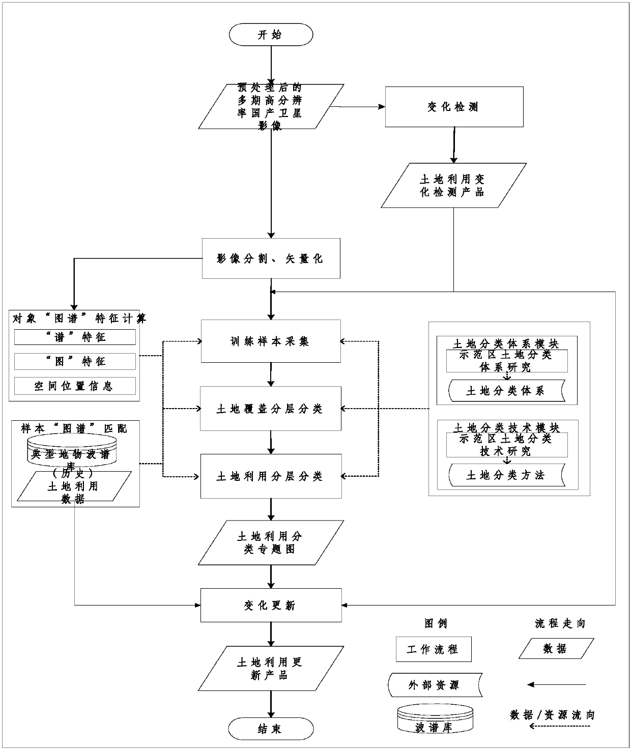
[0015] Such as figure 1 As shown, the present invention will be further introduced below in conjunction with the accompanying drawings.

[0016] It mainly includes the following steps:

[0017] (1) Change detection: According to the application requirements of different domestic satellite data sources and land use change updates, combined with multi-period domestic high-resolution remote sensing image data, the ratio method, difference method, change vector analysis method, and principal component transformation method are realized The change detection method extracts the land use change area, and obtains the distribution map of land use change in different periods.

[0018] (2) Image segmentation: For high-resolution domestic satellite images, the image segmentation algorithm based on mean shift is used to complete the extraction of target image homogeneous primitive objects through segmentation and vectorization. For data sources of different resolutions and types of image...


PUM


Abstract

The invention discloses a remote-sensing satellite image-based highly-automated land utilization updating method. The method includes the steps of: 1) carrying out change detection for image data on which ortho-rectification, image registration and cloud shadow detection preprocessing are already carried out, and extracting a front-back-time-phase land utilization change special-product; 2) obtaining highly homogeneous image segmentation areas, utilizing vectorization technology to generate image object map spots, and using the same as processing units; 3) calculating various map features of the object map spots; 4) collecting training samples to use the same for training of a land utilization classifier; 5) identifying various land utilization land-classes on the basis of land covering classification results to realize extraction of land utilization ground-object information; and 6) combining a change detection product, a base-period land utilization special-map and a land utilizationclassifications special-map, updating special information of change map spots in the base-period land utilization special-map through overlay analysis, and obtaining a present-situation land utilization updating product.

Description

technical field [0001] The invention belongs to the technical field of remote sensing and relates to a highly automatic land utilization update method based on remote sensing satellite images. Background technique [0002] Land is an important natural resource base for human beings to survive. Obtaining land use change information is of great significance for mastering land status and promoting economic development. Obtaining land use change information based on artificial ground surveys is time-consuming and laborious, and at the same time lacks precision in the division of spatial and geographical boundaries of land objects. Therefore, it is necessary to automatically extract land use change information from remote sensing image data to form land use update products and other results to support land planning and government decision-making. [0003] Ziyuan No. 3 satellite is the first civilian high-resolution optical transmission stereoscopic mapping satellite launched by ...

Claims


Application Information

Patent Timeline
IPC IPC(8): G06T7/11
CPCG06T7/11G06T2207/10032G06T2207/20081
Inventor 乔志远傅俏燕隋正伟高青山冯鹏崔林吕争
Owner CHINA CENT FOR RESOURCES SATELLITE DATA & APPL
Why Eureka
Try Eureka