Chinese population spatial gridding method based on night lamplight data

A nighttime lighting and data technology, applied in other database browsing/visualization, image data processing, data processing applications, etc., can solve the problems of lack of population spatial grid research

Inactive Publication Date: 2018-07-06
INST OF REMOTE SENSING & DIGITAL EARTH CHINESE ACADEMY OF SCI
View PDF2 Cites 9 Cited by
  • Summary
  • Abstract
  • Description
  • Claims
  • Application Information

AI Technical Summary

Problems solved by technology

There is relatively little work on systematically correcting nighttime light data and using systematically corrected nighttime light data for population spatial gridding

Method used


Image

  • Chinese population spatial gridding method based on night lamplight data
  • Chinese population spatial gridding method based on night lamplight data
  • Chinese population spatial gridding method based on night lamplight data

Examples


Embodiment Construction

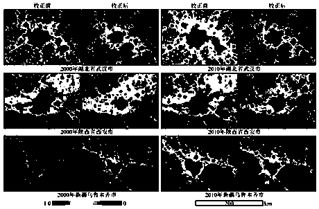
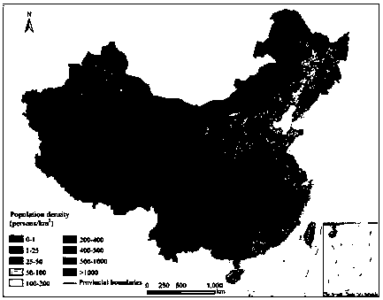
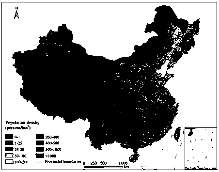
[0027] In the following, "a method for spatial gridding of population in China based on nighttime light data" of the present invention will be further described with reference to the accompanying drawings. The "night light data correction process" involved in the invention is an important innovation. This process is implemented based on ArcGIS software. Figure 1-Figure 5 Shown in detail. The "population space gridization" process involved in the invention is in Image 6 displayed.

[0028] figure 1 The flowchart of the mutual correction of night light data provided by the present invention. Using the Extractby Mask tool of ArcGIS software, the tif image of Sicily, Italy, in the invariant target area, is cropped from the image to be registered and the reference image. The reference image is the nighttime light image acquired by the F15 sensor in 2003, and the other nighttime light images are images to be registered. Using C++ programming, the pixel values ​​of the image t...


PUM


Abstract

The invention discloses a Chinese population spatial gridding method based on night lamplight data. The method comprises the following steps that 1) based on night lamplight data (Nighttime Light Time-series, NLT) acquired by an American defense meteorological satellite program line scanning sensor (Defense Meteorological Satellite Program's Operational Linescan System, DMSP_OLS), a night lamplight data processing flow is researched and developed, and a continuous and compatible night lamplight data set from 1992 to 2013 is acquired; 2) based on population census data and corrected NLT data, population spatialization models of 2000 and 2010 are established, each square kilometer is used as a grid, a Chinese population spatial distribution map is obtained, and the population number of eachgrid is expressed.

Description

technical field [0001] The invention relates to the fields of nighttime lighting data processing and population space gridding, in particular to a method for mutual correction, geometric correction, incompatibility and discontinuity correction of nighttime lighting data, and weakening of lighting saturation and overflow phenomena based on vegetation information . Background technique [0002] China is the largest developing country in the world, and its urbanization rate maintains a rapid growth rate. At the same time, population expansion has brought a series of negative impacts, such as a decrease in arable land, an increase in resource consumption, and serious environmental pollution and damage. Using remote sensing means to grasp the dynamic change information of China's population spatial distribution can provide a scientific theoretical basis for relevant departments to carry out China's urban planning, population regulation, sustainable utilization of resources and ec...

Claims


Application Information

Patent Timeline
Patent Type & Authority Applications(China)
IPC IPC(8): G06F17/30G06Q50/26G06T5/00
CPCG06F16/29G06F16/904G06Q50/26G06T5/006G06T2207/10036G06T2207/20216
Inventor 禹丝思刘芳张增祥施利锋蔡尚书李超
Owner INST OF REMOTE SENSING & DIGITAL EARTH CHINESE ACADEMY OF SCI
Why Eureka
Try Eureka