Cloud-containing remote sensing image compression method based on filling strategy

A remote sensing image and compression method technology, applied in the field of image processing, can solve the problems of not considering the edge information of the filled area, high coding consumption of invalid areas, high coding consumption of high-frequency information, etc., and achieve peak signal-to-noise ratio (PSNR) index improvement and reduction. Coding consumption, reducing the effect of high frequency wavelet coefficients

Active Publication Date: 2021-03-09
XIDIAN UNIV +1
View PDF5 Cites 8 Cited by
  • Summary
  • Abstract
  • Description
  • Claims
  • Application Information

AI Technical Summary

Problems solved by technology

[0007] The invalid area filled by the Phagecyte algorithm is not a single gray value, and the coding consumption of the invalid area is still high; the filling value adopted by the ADR algorithm does not consider the edge information of the filled area, resulting in the edge part after the wavelet transform. A lot of high-frequency information, these high-frequency information will generate high coding consumption;
[0008] The LEC algorithm only considers the outer edge information. If the cloud detection algorithm does not detect the edge cloud, the pixel value of the filled cloud area is closer to the pixel value of the ground object area, and there is still a large pixel difference with the edge cloud, resulting in edge There is still high encoding consumption at

Method used


Image

  • Cloud-containing remote sensing image compression method based on filling strategy
  • Cloud-containing remote sensing image compression method based on filling strategy
  • Cloud-containing remote sensing image compression method based on filling strategy

Examples


Embodiment Construction

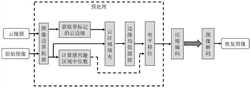
[0035] The specific embodiment of the present invention will be further described below in conjunction with accompanying drawing:

[0036] refer to figure 1 , the specific implementation steps of the present invention are as follows:

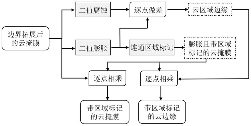
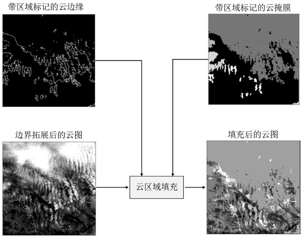
[0037] Step 1: Extend the boundaries of cloud-containing remote sensing images and cloud mask images.

[0038] 1.1) Input the cloud-containing remote sensing image I and the corresponding cloud mask image M, where I is a grayscale image and the bit depth is B N ; M is a binary image, the region of interest is represented by 0, and the cloud region is represented by 1, and the two images have the same size;

[0039] 1.2) Boundary extension of cloudy remote sensing images:

[0040] If W is an odd number and H is an even number, add a column of data to the far right of the original cloud-containing remote sensing image, and the added data is the Wth column data of the original cloud-containing remote sensing image;

[0041] If W is an even numb...


PUM


Abstract

The invention discloses a cloud-containing remote sensing image compression method based on a filling strategy, and mainly solves the problems that in the prior art, the edge of a filled cloud regionstill has more high-frequency information, and the coding consumption is higher. According to the scheme, the method comprises the steps of carrying out boundary extension on an input cloud-containingimage and an input cloud mask image; calculating an approximate median of a region of interest in the cloud-containing image; obtaining a gray mask of a marked cloud region and a gray image of the edge of the marked cloud region; calculating a pixel mean value in the edge of each cloud region and filling the corresponding cloud region; carrying out edge mean filtering on the filled image; performing level shifting on the filtered image by using the approximate median of the region of interest to obtain a preprocessed image; encoding the preprocessed image to obtain a compressed code stream, and sending the compressed code stream to a receiving end; and the receiving end decoding the received code stream to obtain a restored image. The method can effectively reduce the coding rate of the cloud region, improves the recovery quality of the region of interest, and can be used for the transmission of various cloud-containing images.

Description

technical field [0001] The invention belongs to the technical field of image processing, and further relates to a high-efficiency compression method for remote sensing images containing invalid cloud regions, which can be used for transmission and processing of various remote sensing images containing clouds. Background technique [0002] The rapid development of high-resolution remote sensing technology has intensified the contradiction between satellite-ground image transmission bandwidth and remote sensing image data volume. In order to transmit and process acquired images, fast and efficient data compression algorithms are required. However, the ubiquitous cloud areas in remote sensing images occupy a large amount of storage space and transmission bandwidth, which reduces the data ROI of the region of interest, that is, the bandwidth utilization rate of the ground object area data in the image except the cloud area. Therefore, it is of great significance to study image c...

Claims


Application Information

Patent Timeline
Patent Type & Authority Applications(China)
IPC IPC(8): G06T7/13G06T5/30G06T5/00G06T7/187
CPCG06T7/13G06T5/30G06T7/187G06T5/002G06T5/008G06T2207/20104Y02A90/10
Inventor 王柯俨王旭升李云松顾大卫杨丽鋆张建华肖化超韩宇阎昆柴昱洲蒙红英
Owner XIDIAN UNIV
Why Eureka
Try Eureka