Efficient method of location-based content management and delivery

a content management and location technology, applied in the field of location-based content management, can solve the problems of high query rate required to support millions of mobile devices and/or web browsers, inability to support large data sets of existing spatial data provisioning, and inability to efficiently provide location-based content, etc., to achieve fast search, improve search performance, and remove performance bottlenecks associated

Active Publication Date: 2008-04-10
CRAXEL
View PDF33 Cites 69 Cited by
  • Summary
  • Abstract
  • Description
  • Claims
  • Application Information

AI Technical Summary

Benefits of technology

[0018]Another object of embodiments of the invention is to provide a fast way to search a spatial hierarchy distributed over multiple computing resources.
[0019]Another object of embodiments of the invention is t...

Problems solved by technology

In general, existing spatial data provisioning, processing and searching methods can not support a large data set and the high query rate required to support millions of mobile devices and/or web browsers.
However, as the size of the data set indexed by a spatial index grows, the indexing techniques become less and less effective and the rate that searches can be performed is dramatically reduced.
The R-tree becomes less effective as the amount of data held in an R-tree grows.
Because R-trees are built from the bottom-up to fit the data, R-trees require complex splitting algorithms to maintain a balanced tree.
The complex splitting algorithms and data-driven R-tree topology make R-trees very complex and difficult to implement.
While quad-trees easily and efficiently index objects at a single point, quad-trees do not easily index objects with size and shape without limiting performance for larger data sets.
Breaking up objects into multiple objects is very difficult to implement since the calculations involved in splitting geometric shapes are complex.
This second method is also difficult to manage and causes too many objects to be evaluated during searches and other operations.
Unfortunately, this alternative method creates major performance problems because an increasing number of objects end up closer to the root node of the tree as the size of the data set increases.
All indexing methods that use a regular division of space, such as quad-trees, exhibit performance degradation when each of the objects is kept in the deepest node of the tree in which each of the objects is fully contained.
Several attempts have been made to solve the quad-tree problem with limited success, including tiling space with oversized tiles.
However, none of these methods have sufficiently solved the quad-tree scalability problem.
However, since all known spatial indexing techniques degrade as their data sets grow, doub...

Method used


Image

  • Efficient method of location-based content management and delivery
  • Efficient method of location-based content management and delivery
  • Efficient method of location-based content management and delivery

Examples


Embodiment Construction

[0046]Reference will now be made in detail to the preferred embodiments of the invention, examples of which are illustrated in the accompanying drawings. The invention may, however, be embodied in many different forms and should not be construed as being limited to the embodiments set forth herein; rather, these embodiments are provided so that this disclosure will be thorough and complete, and will fully convey the concept of the invention to those skilled in the art.

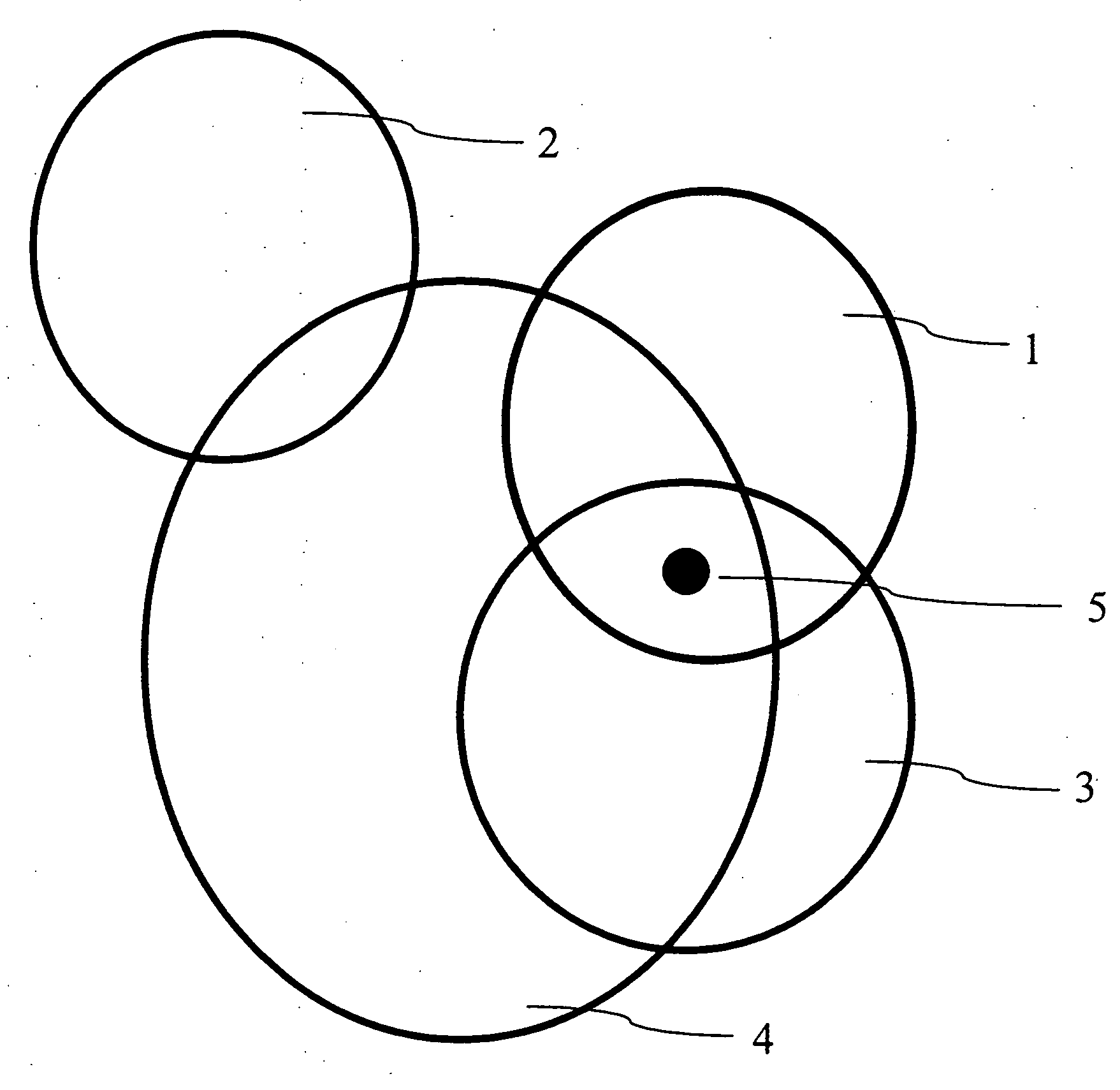
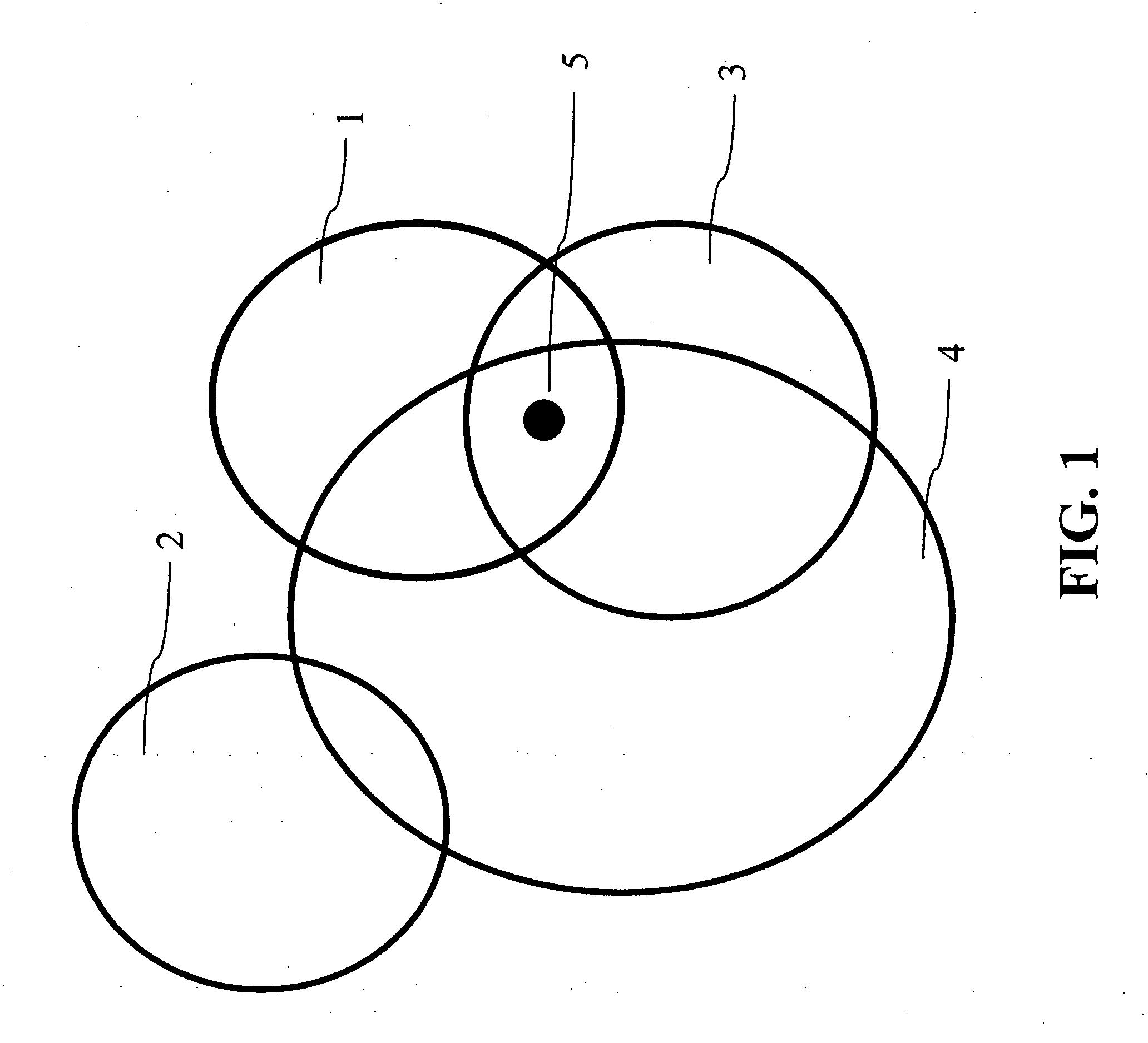
[0047]FIG. 1 shows associating information with areas of influence 1-4 and determining based on a point-in-area query. The information associated with any area of influence that contains point 5 is relevant. As shown in FIG. 1, the information associated with first, third and fourth areas of influence 1, 3, and 4 is relevant. The information associated with the second area of influence 2 is not relevant since the query point 5 is not contained within the second area of influence. By assigning varying areas of influence...


PUM


Abstract

A program storing computer-readable instructions therein for instructing a computer to perform analytical steps for generating a spatial hierarchical identifiers that corresponds to a spatial hierarchy used on a server, the program includes a recording medium readable by the computer; and the computer instructions stored on said recording medium instructing the computer to perform the processes including identifying a position using a position indication system, and generating an identifier within the computer and independent of the server, wherein the identifier identifies first regions within the first spatial hierarchy on the server corresponding to the position.

Description

[0001]This invention claims the benefit of U.S. Provisional Application No. 60 / 849,082 filed on Oct. 4, 2006, which is hereby incorporated by reference in its entirety.BACKGROUND OF THE INVENTION[0002]1. Field of the Invention[0003]The embodiments of the invention relate to location-based content management, and more particularly, to an efficient method of provisioning and processing location-based content. Although embodiments of the invention are suitable for a wide scope of applications, it is particularly suitable for efficient management and delivery of a large amount of location-based content to many mobile devices and web browsers.[0004]2. Discussion of the Related Art[0005]In general, existing spatial data provisioning, processing and searching methods can not support a large data set and the high query rate required to support millions of mobile devices and / or web browsers. Modern search methods make use of indexing techniques to quickly find the data that most likely match...

Claims


Application Information

Patent Timeline
IPC IPC(8): G06F17/30
CPCG06F17/3087G06F17/30241G06F16/29G06F16/9537
Inventor ENGA, DAVID
Owner CRAXEL
Why Eureka
Try Eureka