Location Recording System

a technology of recording system and recording location, applied in the direction of electric signalling details, navigation instruments, instruments, etc., can solve the problems of high power transmitters and practical deployment of dense receiver networks, and achieve the effect of enlarge the coverage area

Active Publication Date: 2008-07-24
MOBIT TELECOM
View PDF21 Cites 50 Cited by
  • Summary
  • Abstract
  • Description
  • Claims
  • Application Information

AI Technical Summary

Benefits of technology

[0037]The present invention combines between both tracking approaches mentioned above, and provides both benefits: the traceable object may carry a small and low power device; still this device can be traced over a wide area, even worldwide, without deploying any further infrastructure. Yet, since low power transmitters as this traceable device are limited in range, and a dense network of receivers is wished to be avoided, the present invention uses “intermediate” communication devices that can contact the traceable device from one hand, and on the other hand can communicate with far away antennas, thus virtually enlarge the coverage area on which the traceable device can be detected. Furthermore, if these intermediate communication devices can be traced, by any means such as GPS or Doppler, then the miniature traceable device could also be traced, at least in the resolution of the intermediate device location.
[0053]a) In one embodiment, the RB and / or SRWD may further comprise an input device, enabling the operator to cause the RB to transmit a “cancel alarm” message.

Problems solved by technology

The first approach can be implemented in a local area, such as a building, warehouse or campus, enabling using small, low power and low cost locatable transmitters, while long range systems may operate countrywide or even worldwide, yet typically require larger and high power transmitters to be located, since it is not practical to deploy a dense network of receivers to detect these transmitters in a wide area.

Method used


Image

  • Location Recording System
  • Location Recording System
  • Location Recording System

Examples


Embodiment Construction

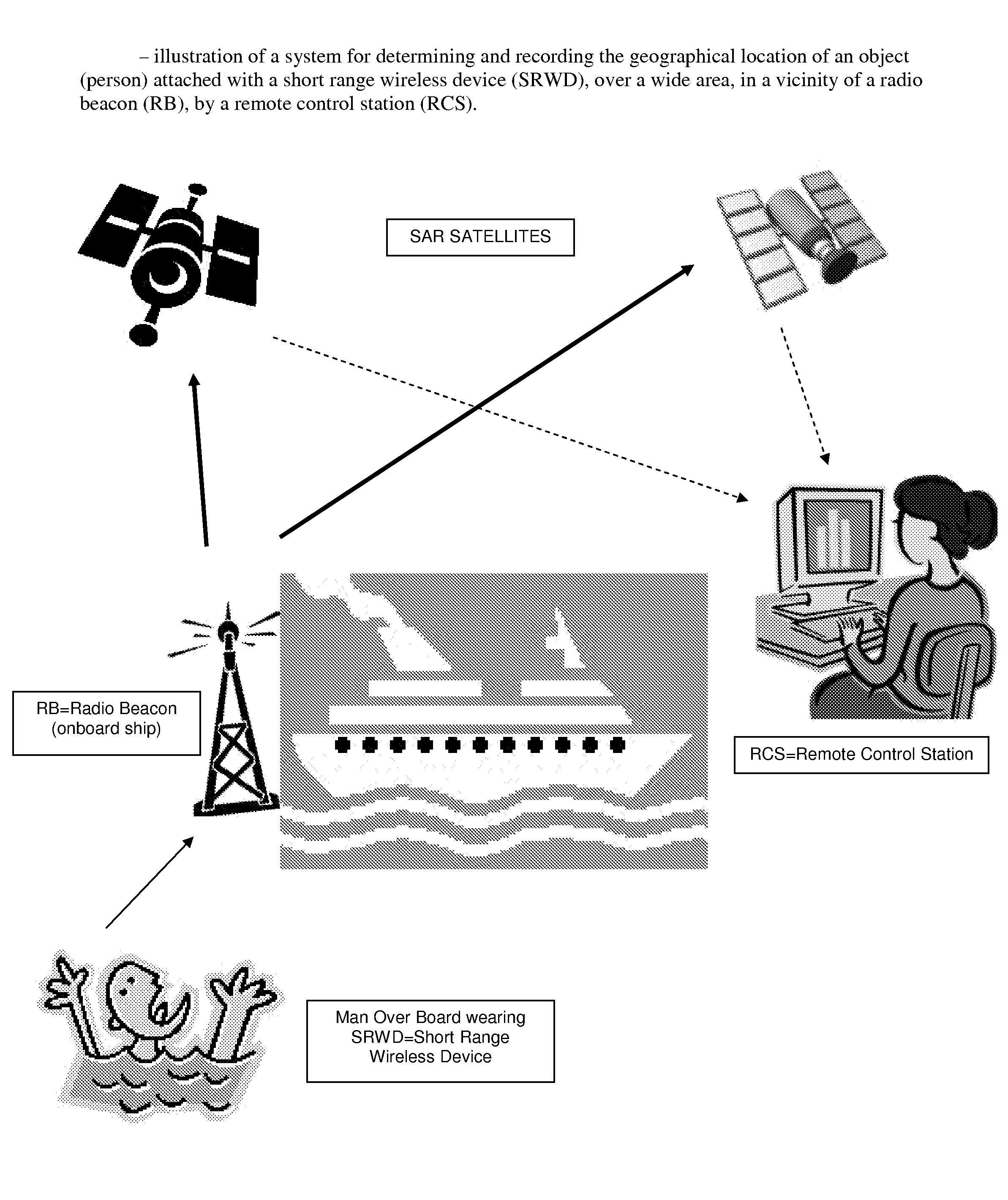
[0086]FIG. 1 is an illustration of a system for determining and recording the geographical location of an object (person, in a preferred embodiment) attached with a short range wireless device (SRWD), over a wide area (worldwide, in the preferred embodiment), in a vicinity of a radio beacon (RB), by a remote control station (RCS).

[0087]In a preferred embodiment, the SRWD is a battery powered device in the size of a wristwatch, wom by a sailor on his / her wrist.

[0088]In this embodiment, SAR satellites are COSPAS-SARSAT satellites, and the RB is a COSPAS-SARSAT compatible maritime beacon (406 MHz EPIRB), modified according to the present invention.

[0089]The RCS in the preferred embodiment is implemented by a PC laptop connected to a 406 MHz receiver.

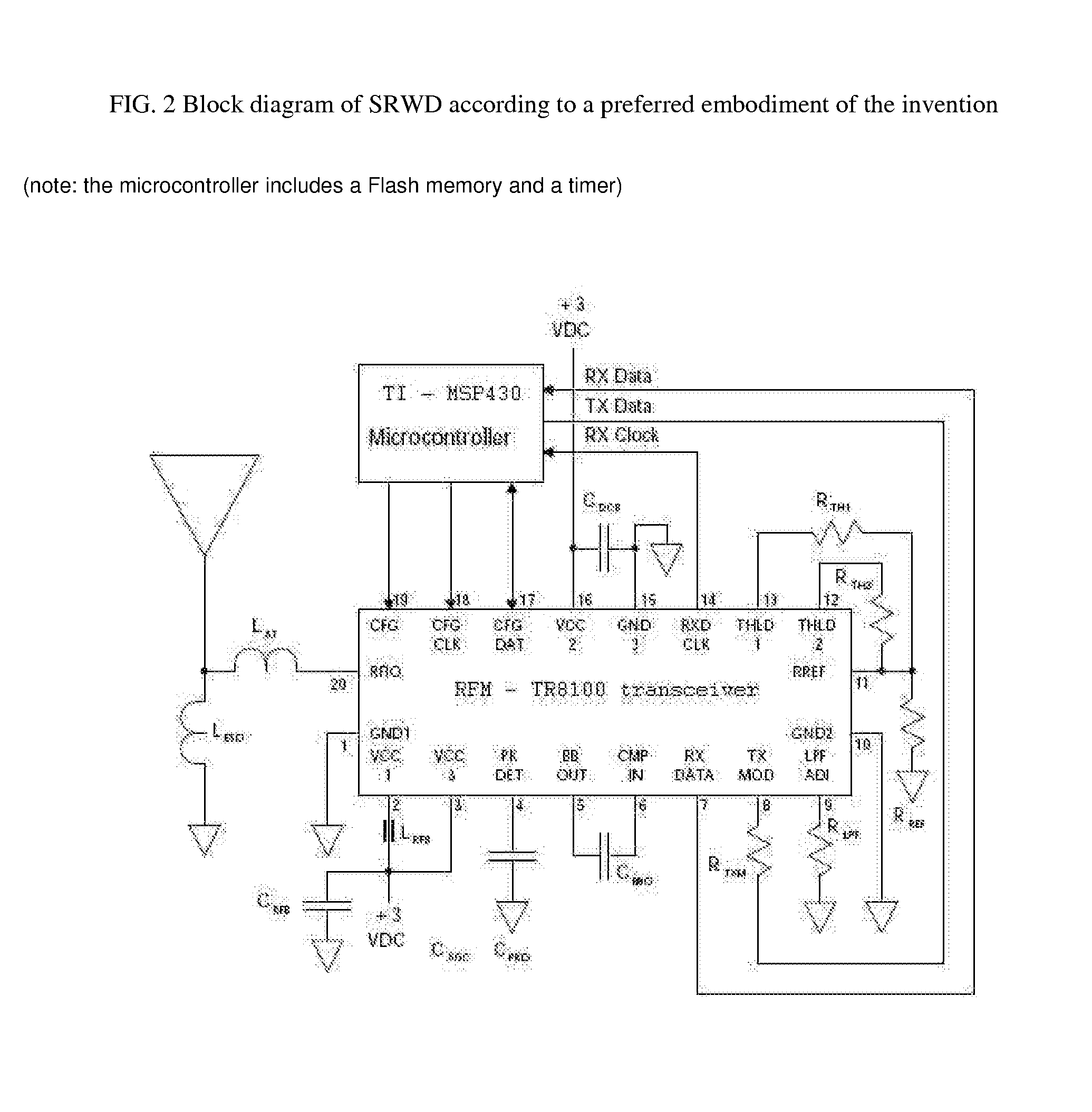
[0090]FIG. 2 is a block diagram of the SRWD according to a preferred embodiment of the invention. In this embodiment, the SRWD is based on:[0091]a) a low power single chip transceiver, TR8100, operating on the 915 MHz ISM band, manufactured...


PUM


Abstract

The present invention discloses a communication system and method for determining and recording the geographical location of an object attached with a short range wireless device, over a wide area, in a vicinity of a radio beacon that can be located by a remote control station, upon establishing or interrupting a wireless connection between said wireless device and said radio beacon. One embodiment of the invention relates to a system for search and rescue of a man overboard (person overboard), a quite frequent and fatal accident at sea.

Description

BACKGROUND OF INVENTION[0001]Too many persons are lost at sea due to accidents and lack of efficiently informing rescue teams of their fatal situation.[0002]These situations become particularly difficult to deal with as they occur far away offshore, in hostile environmental conditions, with limited local resources for treatment.[0003]The detection and location of an aircraft crash or maritime distress is of paramount importance to the search and rescue (SAR) teams and to the potential survivors. Studies show that while the initial survivors of an aircraft crash have less than a 10% chance of survival if rescue is delayed beyond two days, the survival rate is over 60% if the rescue can be accomplished within eight hours. Similar urgency applies in maritime distress situations, particularly where injuries have occurred. Furthermore, accurate location of the distress can significantly reduce both SAR costs and the exposure of rescue forces to hazardous conditions, and clearly improve e...

Claims


Application Information

Patent Timeline
Patent Type & Authority Applications(United States)
IPC IPC(8): G01S1/00G01S5/02G01S19/17G01S19/48
CPCG01S19/17B63C9/0005G08B21/088G08B21/0288
Inventor KATZ, DANIEL A.
Owner MOBIT TELECOM
Why Eureka
Try Eureka