Beam steered broadband marine survey method and system

Inactive Publication Date: 2015-08-13
CGG SERVICES SA
View PDF1 Cites 3 Cited by
  • Summary
  • Abstract
  • Description
  • Claims
  • Application Information

AI Technical Summary

Benefits of technology

The patent describes a method for improving the quality of data collected in a seismic survey of underground formations. The method involves towing a source and a receiver array, calculating a non-vertical steering angle to enhance the high-frequency signals from the shallow subsurface reflections, and generating an imaging wave that propagates with the non-vertical steering angle relative to gravity. This results in a more accurate and precise image of the underground formations, providing better data resolution.

Problems solved by technology

Furthermore, sources at a common depth that are fired simultaneously may have identical imaging notches and a poor response at higher frequencies.
Applicants have observed that despite various efforts to broaden the frequency response of the recorded seismic data (including those mentioned above), the signal-to-noise ratio of high-frequency seismic data is often poor and limits the effectiveness of such efforts.

Method used


Image

  • Beam steered broadband marine survey method and system
  • Beam steered broadband marine survey method and system
  • Beam steered broadband marine survey method and system

Examples


Embodiment Construction

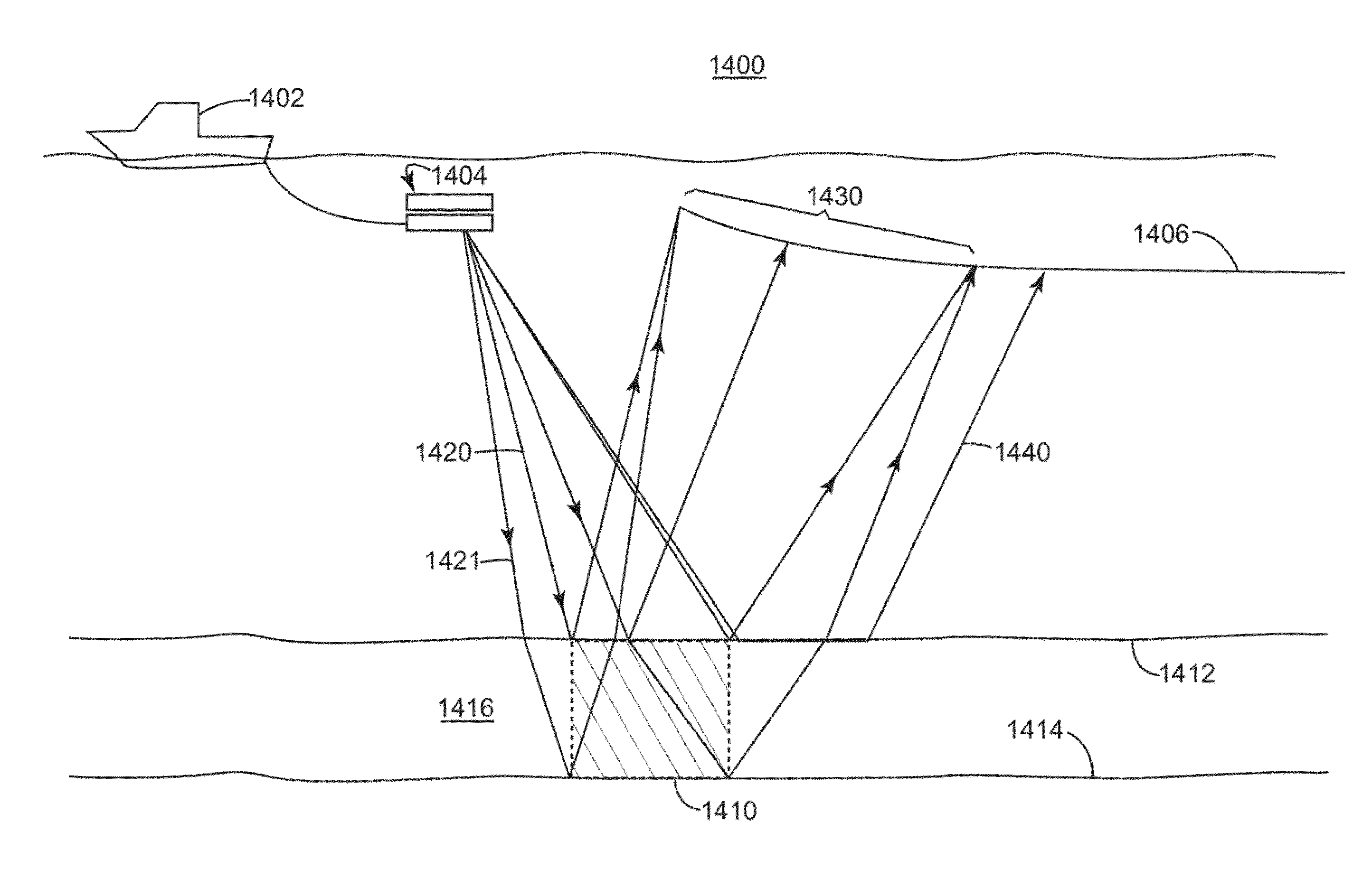
[0034]The following description of various embodiments refers to the accompanying drawings. The same reference numbers in different drawings identify the same or similar elements. The following detailed description does not limit the invention. Instead, the scope of the invention is defined by the appended claims. For simplicity, the following embodiments are discussed, in general, with regard to two-dimensional (2D) wave-field propagation. However, the embodiments to be discussed next are not limited to 2D wave-fields, but may be also applied to 3D wave-fields.

[0035]Reference throughout the specification to “one embodiment” or “an embodiment” means that a particular feature, structure, or characteristic described in connection with an embodiment is included in at least one embodiment of the subject matter disclosed. Thus, the appearance of the phrases “in one embodiment” or “in an embodiment” in various places throughout the specification is not necessarily referring to the same em...


PUM


Abstract

A method for improving data resolution in a broad band marine seismic survey. The method includes towing a source array and a receiver array; calculating a non-vertical steering angle to improve a magnitude of a high frequency part of a shallow zone of subsurface reflections that arrive at a selected region of the receiver array over a magnitude of subsurface reflections that would arrive at the selected region of the receiver array for a substantially vertical imaging wave; generating an imaging wave to propagate substantially with the non-vertical steering angle relative to gravity; and recording seismic data corresponding to the imaging wave.

Description

BACKGROUND[0001]1. Technical Field[0002]The subject matter disclosed herein relates generally to the field of geophysical data acquisition and processing. More particularly, the subject matter relates to the field of geophysical surveys in marine environments.[0003]2. Discussion of the Background[0004]Geophysical data is useful for a variety of applications such as weather and climate forecasting, environmental monitoring, agriculture, mining, and seismology. As the economic benefits of such data have been proven, and additional applications for geophysical data have been discovered and developed, the demand for localized, high-resolution, and cost-effective geophysical data has greatly increased. This trend is expected to continue.[0005]For example, seismic data acquisition and processing may be used to generate a profile (image) of the geophysical structure under the ground (either on land or seabed). While this profile does not provide an exact location for hydrocarbon reservoirs...

Claims


Application Information

Patent Timeline
IPC IPC(8): G01V1/28G01V1/18G01V1/38
CPCG01V1/28G01V2210/59G01V1/18G01V1/3808
Inventor TONCHIA, HELENE
Owner CGG SERVICES SA
Why Eureka
Try Eureka