Geographic information system (GIS)-based industrial cluster information integration service system and method

A technology of industrial clusters and service systems, applied in the field of information integration service systems, can solve the problems of inability to roam freely, large storage space, heavy server load, etc.

Inactive Publication Date: 2010-12-08
BEIJING ZHONGJIKEHAI TECH & DEV
View PDF2 Cites 32 Cited by
  • Summary
  • Abstract
  • Description
  • Claims
  • Application Information

AI Technical Summary

Problems solved by technology

[0009] (2) Massive image data, if it is not processed, even if it is a broadband high-speed network, the image cannot roam freely on the Internet at various scales, and requires a large amount of storage space. Spatial data compression affects the speed of browsing image data on the network
[0012] (4) Since the traditional dynamic electronic map dynamically generates a grid map for the range requested by the client during network transmission, and then transmits it to the client for display, the efficiency is low, and each time the user requests the graphics of the range, it needs to dynamically generate, which places a heavy load on the server
[0014] (6) Since the size of the cache directly affects the efficiency of image roaming, if it is too small, it will frequently read intermediate image files, if it is too large, it will be limited by the computer memory, and the reading of a large amount of data will also cause a delay in speed

Method used


Image

  • Geographic information system (GIS)-based industrial cluster information integration service system and method
  • Geographic information system (GIS)-based industrial cluster information integration service system and method
  • Geographic information system (GIS)-based industrial cluster information integration service system and method

Examples


Embodiment Construction

[0045] In order to make the purpose, technical solution and advantages of the present invention clearer, the present invention will be further described in detail below with reference to the accompanying drawings and embodiments. It should be understood that the following examples are only used to explain the present invention and are not intended to limit the present invention, that is, the protection scope of the present invention is not limited to the following examples. On the contrary, according to the concept of the present invention, those skilled in the art Appropriate changes can be made by skilled persons, and these changes can fall within the scope of the invention defined by the claims.
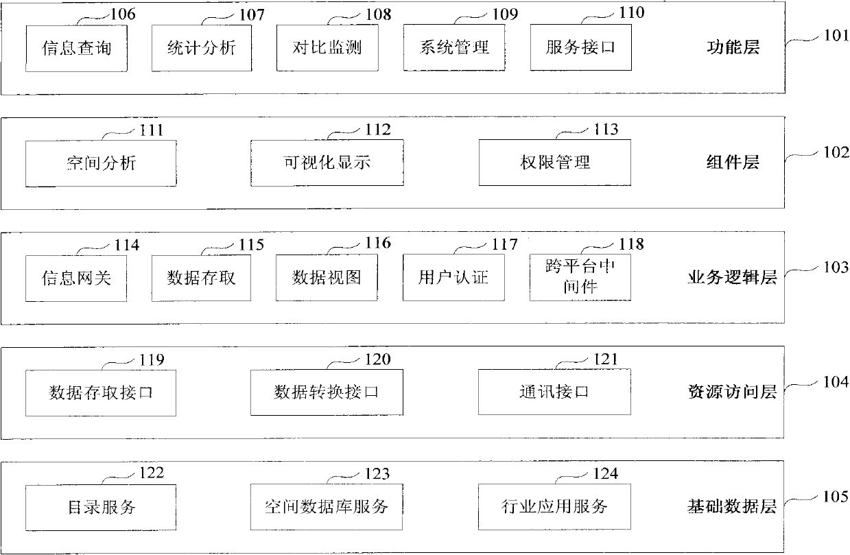
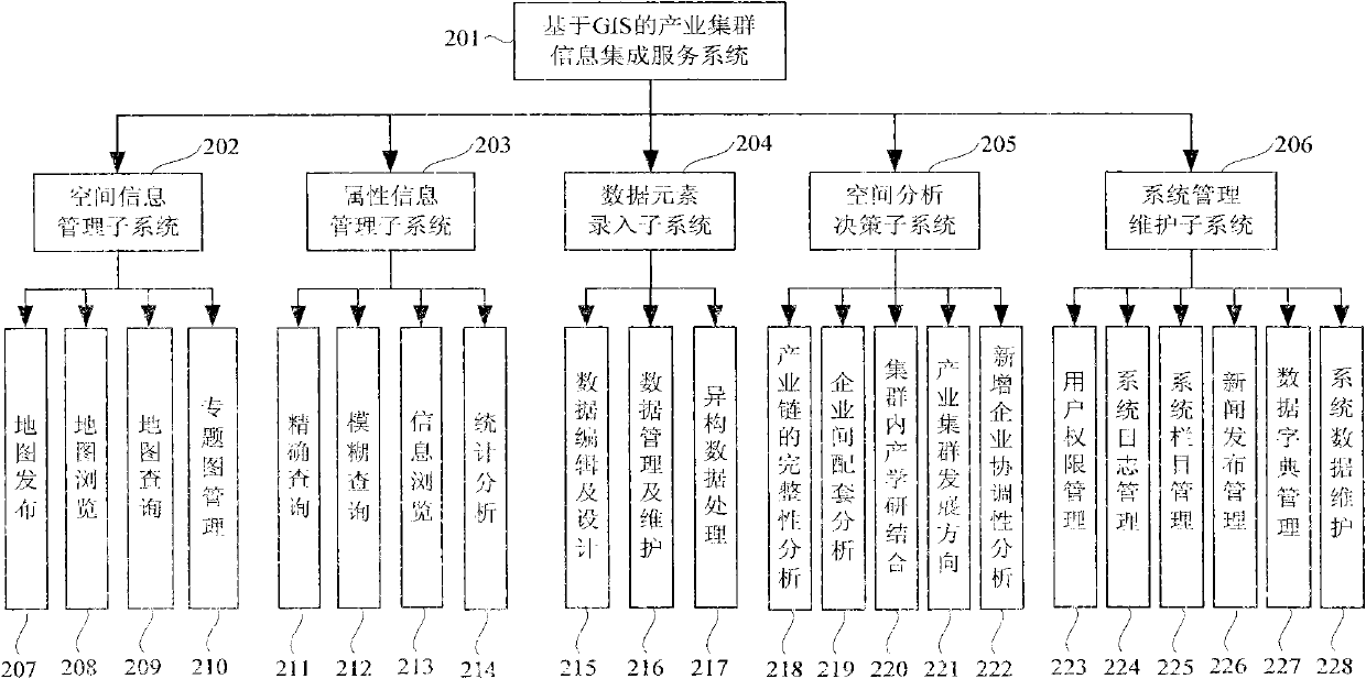
[0046] The basic idea of ​​the present invention is: an embodiment of the present invention provides a data maintenance integration interface for spatial information and industrial cluster information, including: spatial geographic information management and industrial cluster info...


PUM


Abstract

The invention relates to the field of industrial cluster information integration services, in particular to a geographic information system (GIS)-based industrial cluster information integration and service method and an information integration service system adopting the same. The system mainly comprises a spatial information management subsystem, an attribute information management subsystem, a data element input subsystem, a spatial analysis and policy-making subsystem and a system management and maintenance subsystem. The GIS-based industrial cluster information integration service system and the GIS-based industrial cluster information integration method of the invention have the advantages of introducing advanced GIS technology to realize the mapping and corresponding of spatial information and many kinds of attribute information and meet the requirements of system users on the advancement, accuracy and timeliness of geographic information and technical information, and visibly, conveniently and fast providing the public service support of the resources of geographic orientations, equipment, technology, processes, products and the like for enterprises in and among clusters by utilizing content-based information processing technology and performing intelligent analysis through networks.

Description

technical field [0001] The present invention relates to the field of industrial cluster information integration services, in particular to an industrial cluster information integration and service method based on Geographic Information System (GIS for short), and an information integration service system including the method. Background technique [0002] GIS is a computer-based tool for mapping and analyzing things or events. GIS technology integrates the visual effects of maps and geographic analysis functions with general database operations, and can be widely used in issues such as explaining events, predicting results, and planning strategies among the public and individuals, enterprises and institutions. The GIS-based industrial cluster information integration service system integrates technical information spatial analysis and visual display technology, realizes the statistical analysis of cluster technical information based on geographical information, and then impro...

Claims


Application Information

Patent Timeline
Patent Type & Authority Applications(China)
IPC IPC(8): G06Q10/00G06Q50/00G06Q10/06G06Q50/10
Inventor 李春梅李艾丹郭秋梅薛中玉程玄根
Owner BEIJING ZHONGJIKEHAI TECH & DEV
Why Eureka
Try Eureka