Map displaying method for self-driving travel roadtrain navigation

A display method and fleet technology, applied in the field of map display for self-driving tour fleet navigation, can solve the problems of not being able to display the positions of all vehicles in the fleet, small scale, etc., achieve friendly human-computer interaction, avoid falling behind, and improve the experience

Inactive Publication Date: 2014-01-22
XIAMEN YAXON NETWORKS CO LTD
View PDF5 Cites 28 Cited by
  • Summary
  • Abstract
  • Description
  • Claims
  • Application Information

AI Technical Summary

Problems solved by technology

However, the scale of the current map frame is usually too small to display the positions of all vehicles in the fleet within the current screen range. To view the positions of all vehicles in the fleet, the user needs to manually switch the scale or drag the map to select a suitable field of view to display Location of all vehicles in the fleet

Method used


Image

  • Map displaying method for self-driving travel roadtrain navigation
  • Map displaying method for self-driving travel roadtrain navigation

Examples


Embodiment Construction

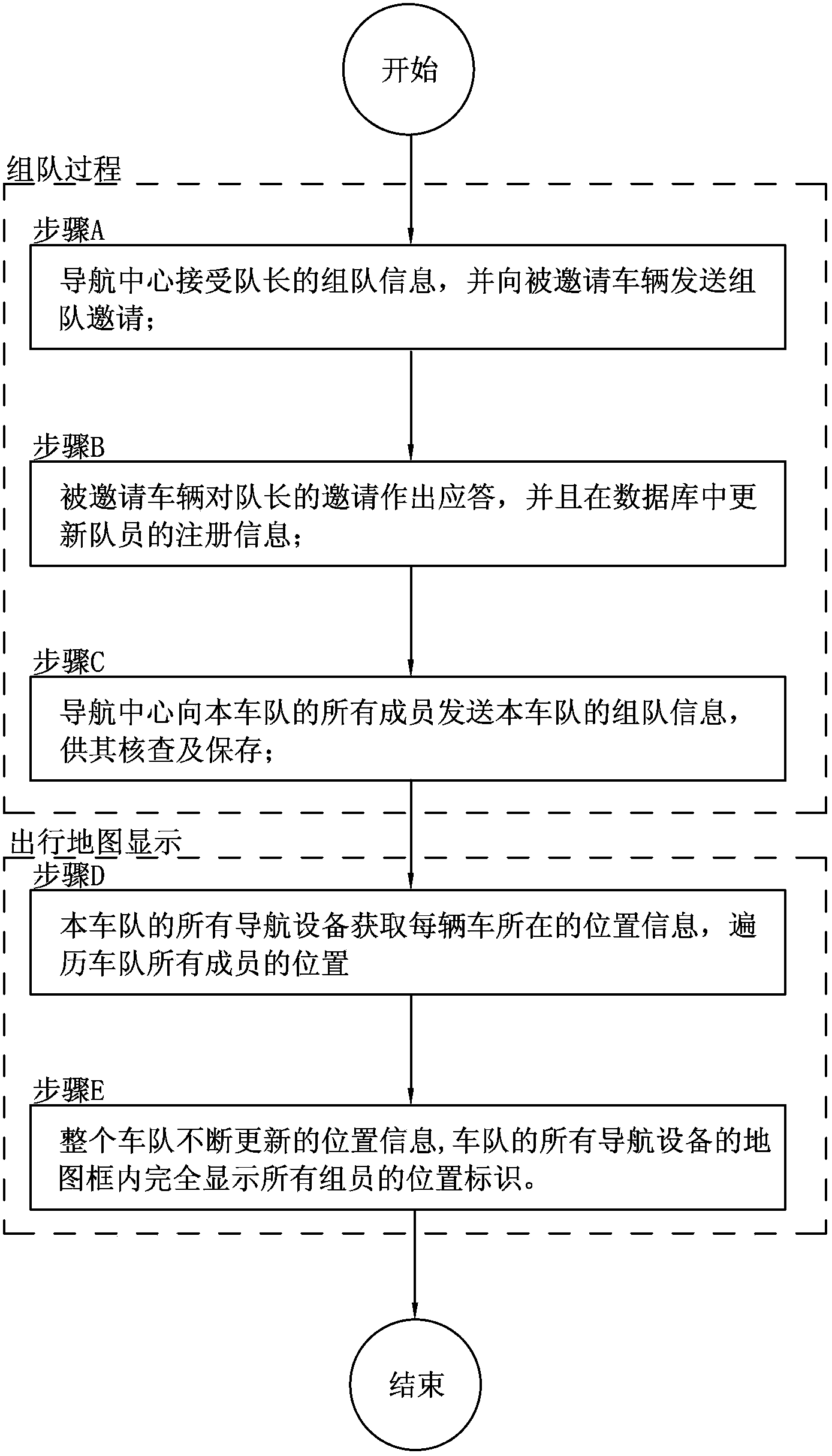
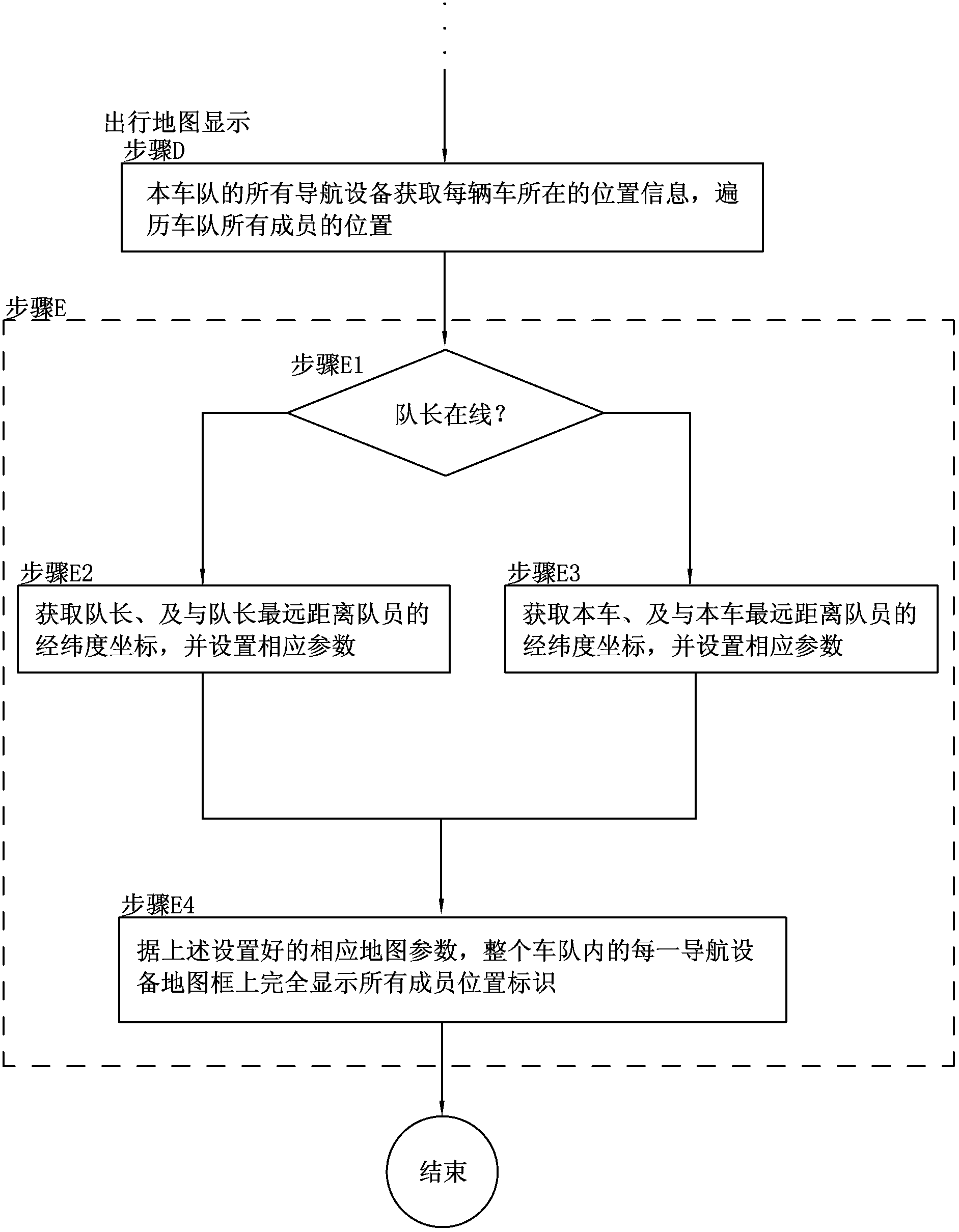
[0031] In order to make the technical problems, technical solutions and beneficial effects to be solved by the present invention clearer and clearer, the present invention will be further described in detail below in conjunction with the accompanying drawings and embodiments. It should be understood that the specific embodiments described here are only used to explain the present invention, not to limit the present invention.

[0032] Such as figure 1 As shown, the map display method for self-driving tour group navigation in the present invention is suitable for a central navigation system. The navigation equipment on the vehicles participating in the self-driving tour in the central navigation system may include a GPRS module for mobile digital communication, a GPS module for satellite positioning function, and an electronic map navigation function, and may also include a mobile phone module for realizing the communication function of a mobile phone. Each navigation device i...


PUM


Abstract

The invention discloses a map displaying method for self-driving travel roadtrain navigation. A navigation center receives team forming information sent by any vehicle, comprising a path, invited vehicles, activity time and content; the navigation center transmits team forming invitation transmitted by the navigation center as a captain to invited vehicles; the navigation center receives the answerback of the invited vehicles to the team forming information; the navigation center sends the team forming logon message of the roadtrain to all member vehicles of the roadtrain; all navigation equipment in the whole roadtrain obtain the position information of each vehicle of the roadtrain from the navigation center at regular time; the corresponding scale is set so that a map frame of each navigation equipment in the whole roadtrain can completely display position identification of all members according to the continually updating position information of the whole roadtrain. According to the scheme, when the position information of all the members of the whole roadtrain generates variation, a map frame of each navigation equipment is changed according to the updating position, and all the members of the whole roadtrain are automatically displayed in the map frame.

Description

technical field [0001] The invention relates to a map display method, in particular to a map display method for self-driving tour group navigation. Background technique [0002] In the existing self-driving tour fleet navigation system, more user-friendly functions can be implemented for multiple members of the current fleet through the server, including checking the positions of other members of the fleet, issuing announcements, and the like. During the navigation process of the self-driving tour team, the most concerned issue of the user is to know the vehicle position of other team members in real time. However, the scale of the current map frame is usually too small to display the positions of all vehicles in the fleet within the current screen range. To view the positions of all vehicles in the fleet, the user needs to manually switch the scale or drag the map to select a suitable field of view to display The location of all vehicles in the fleet. And when the positio...

Claims


Application Information

Patent Timeline
Patent Type & Authority Applications(China)
IPC IPC(8): G01C21/36G01C21/30
CPCG01C21/367G01C21/3676G08G1/20
Inventor 解玉芳陈从华庄宗辉钟可华
Owner XIAMEN YAXON NETWORKS CO LTD
Why Eureka
Try Eureka