Processing method and device of remote-sensing image data

A remote sensing image and data processing technology, applied in image data processing, image enhancement, image analysis, etc., can solve the problems of large workload, long time, and large human error.

Active Publication Date: 2015-04-29
BEIJING AEROSPACE HONGTU INFORMATION TECH
View PDF2 Cites 6 Cited by
  • Summary
  • Abstract
  • Description
  • Claims
  • Application Information

AI Technical Summary

Problems solved by technology

[0004] The present invention provides a method for processing remote sensing image data, which is used to solve the problems in the prior art that cannot

Method used


Image

  • Processing method and device of remote-sensing image data
  • Processing method and device of remote-sensing image data
  • Processing method and device of remote-sensing image data

Examples


Embodiment Construction

[0022] In order to make the above objects, features and advantages of the present invention more comprehensible, the present invention will be further described in detail below in conjunction with the accompanying drawings and specific embodiments.

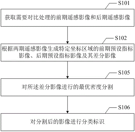
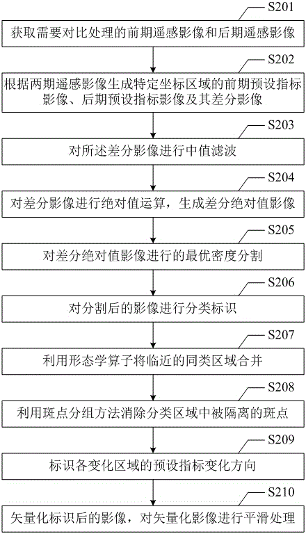
[0023] refer to figure 1 , shows the flow of the first embodiment of the remote sensing image data processing method of the present invention, including the following steps:

[0024] Step S101: Acquiring the remote sensing image in the early stage and the remote sensing image in the later stage that need to be compared and processed;

[0025] Step S102: Generate the pre-preset index image, the post-preset index image, and the difference image between the post-preset index image and the pre-preset index image of the specific coordinate area according to the two remote sensing images;

[0026] Regarding the specific coordinate area, it can be the coordinate overlap area of ​​the two phases of remote sensing images, or it can be spe...


PUM


Abstract

The invention provides a processing method and device of remote-sensing image data. The method comprises the steps that an earlier-stage remote-sensing image and a later-stage remote-sensing image are acquired, and according to the earlier-stage remote-sensing image and the later-stage remote-sensing image, an earlier-stage preset index image and a later-stage preset index image in a specific coordinate area and a difference image of the later-stage preset index image and the earlier-stage preset index image are generated; optimal density segmentation is carried out on the difference image; images obtained after segmentation are classified and marked. By means of the method, the changes of preset indexes (like the NDVI) of the earlier-stage remote-sensing image and the later-stage remote-sensing image can be automatically marked, and the problems that in the prior art, because the changes of ground objects can not be automatically identified based on the remote-sensing image data, marking workload is large, marking time is long and personal errors are large are solved.

Description

technical field [0001] The present invention relates to the technical field of geographic information data processing, in particular, to a remote sensing image data processing method and device. Background technique [0002] With the development of remote sensing satellite technology, remote sensing image data has become an important data source for geographic information acquisition and analysis. The following uses forest land change monitoring as an example to illustrate. [0003] Forestry is a production sector that maintains ecological balance, cultivates and protects forests to obtain timber and other forest products, and utilizes the natural characteristics of forest trees to play a protective role. It is one of the important components of the national economy. my country's forest coverage rate is only 16.55%, and the total forest stock volume is less than 3% of the world's total. Due to production and construction occupation, felling, and growth degradation, forest r...

Claims


Application Information

Patent Timeline
IPC IPC(8): G06T7/00
CPCG06T7/155G06T2207/10032G06T2207/30188
Inventor 张欢欢刘东升杜伟李静
Owner BEIJING AEROSPACE HONGTU INFORMATION TECH
Why Eureka
Try Eureka