Method for detecting polygonal ground object by using line section space relationship

A technology of spatial relationship and line segment, applied in the field of remote sensing image processing, can solve the problems of high degree of automation and non-universal feature extraction algorithm, and achieve the effect of high automation

Inactive Publication Date: 2016-07-06
FUJIAN NORMAL UNIV
View PDF3 Cites 8 Cited by
  • Summary
  • Abstract
  • Description
  • Claims
  • Application Information

AI Technical Summary

Problems solved by technology

[0003] The invention provides a method for detecting polygonal ground objects by using the spatial relationship of line segments, which can overcome the problem that the current extraction algorithm of ground objects in remote sensing images is not universal. By using the idea of ​​graph theory, it can accurately Realize the extraction of ground features of various shapes without manual intervention, with a high degree of automation

Method used


Image

  • Method for detecting polygonal ground object by using line section space relationship

Examples


Embodiment Construction

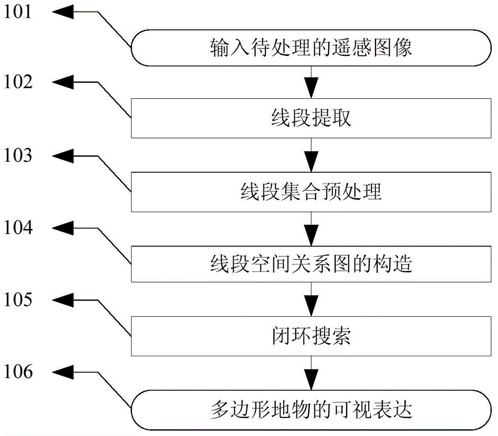
[0012] Specific embodiments of the present invention will be described in detail below in conjunction with the accompanying drawings.

[0013] In step 101, a remote sensing image image to be processed is input.

[0014] In step 102, first use the Canny algorithm to detect the edge of the remote sensing image image in step 101, and then use the connection edge labeling algorithm to extract the linear elements to obtain the line segment set Lset, record and keep two of each line segment in the line segment set Lset endpoint.

[0015] In step 103, in order to improve the efficiency and detection accuracy of the algorithm, the line segment set Lset in step 102 is preprocessed to obtain the candidate line segment set Lset_c: ① set the length threshold TH_L, and delete short line segments whose length is less than TH_L; ② set the angle threshold TH_A, Delete the line segments that do not have a parallel relationship and the included angle is smaller than TH_A; ③Considering the infl...


PUM


Abstract

The invention relates to a method for detecting a polygonal ground object by using the line section space relationship. The method comprises the following steps of 1, firstly performing edge detection, then performing extraction to obtain a line section set Lset, and recording and remaining two end points of each line section in the line section set Lset; 2, performing preprocessing on the line section set Lset, setting a length threshold value TH_L, and deleting short line sections with the length smaller than the TH_L; 3, mapping each line section in a candidate line section set Lset_c into a vertex in a non-directed graph; and 4, searching a closed loop in a line section space relationship graph, extending the line sections corresponding to each vertex in the non-directed graph, and obtaining the profile of the detected ground object. The method provided by the invention solves the problem that the ground object extraction in a remote sensing image does not have the universality. The method has high automation, and the result can be used for extracting the artificial ground objects in various shapes in a complicated scene.

Description

technical field [0001] The invention relates to the field of remote sensing image processing, in particular to a method for detecting polygonal ground objects by utilizing the spatial relationship of line segments. Background technique [0002] Extracting artificial features such as buildings and roads from remote sensing images is an important content of remote sensing image information extraction. At present, there are a lot of research on edges and contours, but most algorithms need to make assumptions about the types of features to be extracted, such as hypothetical ground features The outline of the object is rectangular, but the shape of the actual ground object is diverse, and it needs to be expressed by various polygons. Contents of the invention [0003] The invention provides a method for detecting polygonal ground objects by using the spatial relationship of line segments, which can overcome the problem that the current extraction algorithm of ground objects in ...

Claims


Application Information

Patent Timeline
Patent Type & Authority Applications(China)
IPC IPC(8): G06K9/46
CPCG06V10/457
Inventor 施文灶
Owner FUJIAN NORMAL UNIV
Why Eureka
Try Eureka