InSAR high precision and high resolution DEM acquisition method combined with external control point

A high-resolution, acquisition method technology, applied in the field of high-resolution and high-precision DEM, to achieve clear process structure, high resolution, and simple effects

Active Publication Date: 2016-09-07
CENT SOUTHERN CHINA ELECTRIC POWER DESIGN INST CHINA POWER ENG CONSULTING GROUP CORP +1
View PDF4 Cites 23 Cited by
  • Summary
  • Abstract
  • Description
  • Claims
  • Application Information

AI Technical Summary

Problems solved by technology

[0013] To sum up, at present, TanDEM-X CoSSC data and InSAR differential interferometry can be used to obtain high-resolution DEM products, but their elevations are relative, and are affected by

Method used


Image

  • InSAR high precision and high resolution DEM acquisition method combined with external control point
  • InSAR high precision and high resolution DEM acquisition method combined with external control point
  • InSAR high precision and high resolution DEM acquisition method combined with external control point

Examples


Embodiment Construction

[0056] The present invention will be further described below in conjunction with the accompanying drawings and embodiments.

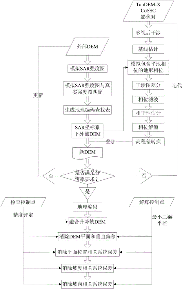
[0057] An InSAR high-precision and high-resolution DEM acquisition method combined with external control points, the external control points are external control points, such as figure 1 shown, including:

[0058] Step 1. Process the single-track image pair through bi-base InSAR differential interferometry to obtain the single-track DEM;

[0059] Step 1.1, customize the image pair according to the coordinate range of the DEM demand area, the image pair includes the main image and the auxiliary image;

[0060] Step 1.2, multiply the main image and the auxiliary image conjugate to generate an initial interferogram;

[0061] Step 1.3, estimate the baseline from the orbital data, and simulate the topographic phase map including the flat-Earth phase from the external DEM according to the baseline;

[0062] Step 1.4, subtracting the topographic phase map f...


PUM


Abstract

The present invention discloses an InSAR high precision and high resolution DEM acquisition method combined with an external control point. The characteristics of high resolution, high relative precision, large coverage range and high ground control point absolute precision of an InSAR monitoring mean are fully integrated, the low InSAR obtainment DEM absolute precision is solved, the defects of the low cost-effectiveness ratio and the influence of cloud of obtaining high resolution mapping of a traditional DEM obtainment method such as airborne and airborne optical and laser height measurement mean, time-consuming and labor-consuming of ground mapping and no obtainment of a whole field mountain high resolution topography are overcome. The structure of the whole process is clear, and the method has the advantages of simple realization, low cost, high monitoring precision, large monitoring range, and high degree of automation.

Description

technical field [0001] The invention belongs to the field of geodesy based on remote sensing images, and is a method for obtaining high-resolution and high-precision DEM by using InSAR (Synthetic Aperture Interference Radar) technology and external control points. Background technique [0002] Due to its all-weather, large-scale, and high-precision observation capabilities, Interferometric Synthetic Aperture radar (InSAR) has become a hot technology at home and abroad. With the launch of various SAR sensors such as JERS, ERS-1 / 2, ENVISAT, ALOS / PALSAR, ALOS-2 / PALSAR-2, RadarSat-1 / 2, TerraSAR-X, COSMO-SkyMed, Sentinel-1 etc., the temporal and spatial resolution of available SAR data has been continuously improved, and this technology has achieved unprecedented development and development in monitoring surface deformation caused by groundwater extraction, coal mining, oil extraction, underground railway construction, reclamation, earthquakes, glaciers, etc. application. InSAR...

Claims


Application Information

Patent Timeline
IPC IPC(8): G01S13/90
CPCG01S13/9023
Inventor 程正逢胡俊张健李佳陈功杜亚男周毅曾渠丰刘佳莹
Owner CENT SOUTHERN CHINA ELECTRIC POWER DESIGN INST CHINA POWER ENG CONSULTING GROUP CORP
Why Eureka
Try Eureka