Depth domain stratal configuration inversion method based on geological information mapping

A technology of information mapping and depth domain, which is applied in the field of oilfield development and can solve problems such as depth mismatch.

Inactive Publication Date: 2016-11-09
CHINA PETROLEUM & CHEM CORP +1
View PDF3 Cites 12 Cited by
  • Summary
  • Abstract
  • Description
  • Claims
  • Application Information

AI Technical Summary

Problems solved by technology

[0006] However, the above studies did not solve the problems of depth mismatch in the conversion from depth domain to time domain and time-depth conversion in the inversion process.

Method used


Image

  • Depth domain stratal configuration inversion method based on geological information mapping
  • Depth domain stratal configuration inversion method based on geological information mapping
  • Depth domain stratal configuration inversion method based on geological information mapping

Examples


Embodiment Construction

[0019] In order to make the above and other objects, features and advantages of the present invention more comprehensible, the preferred embodiments are listed below and shown in the accompanying drawings in detail as follows.

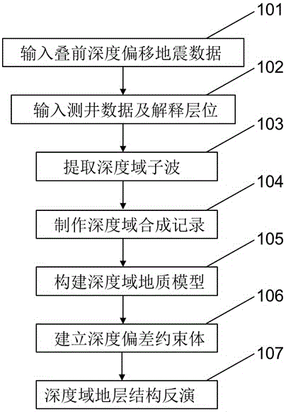
[0020] Such as figure 1 as shown, figure 1 It is a flow chart of the depth domain stratum structure inversion method based on geological information mapping of the present invention.

[0021] In step 101, a prestack depth migration seismic data volume is input. In one embodiment, the input prestack depth migration seismic data volume is a standard segy format file. The process goes to step 102.

[0022] In step 102, well logging data and interpreted horizons are input. The data format of the input interpretation horizon data is abscissa, ordinate and time value. The process goes to step 103.

[0023] In step 103, by analyzing the depth domain logging data and seismic data in the study area, selecting appropriate velocity and resampling interval p...


PUM


Abstract

The invention provides a depth domain stratal configuration inversion method based on geological information mapping. The method comprises steps of inputting a prestack depth migration seismic data volume; inputting logging data and interpretation horizon; establishing a speed model and extracting a depth domain wavelet; making a depth domain synthetic record and conducting horizon calibration; establishing a reasonable construction frame geological model; establishing a depth deviation obligatory point based on the geological model; and adopting a rapid threshold convergence iterative algorithm to achieve basis pursuit stratal configuration inversion based on geological information mapping. The depth domain stratal configuration inversion method based on geological information mapping can obtain a data volume of directly representing vertical and horizontal change of a geological body by means of seismic data of the depth domain, overcomes high frequency information loss caused by resampling in the logging curve time-depth conversion process, effectively ensures high resolution of seismic inversion, and finally achieves an object of directly predicting reservoir lithology, physical properties and oil-gas possibility by means of depth domain data.

Description

technical field [0001] The invention relates to the technical field of oil field development, in particular to a depth-domain formation structure inversion method based on geological information mapping. Background technique [0002] The inversion of seismic parameters in time domain started in the early 1900s and became popular in the 1980s. In the early stage, it was mainly common inverse regression method (such as VELOG, SEISLOG, etc.) and sparse pulse method (such as MED, AR, MLD, BED, etc.). The resolution of inversion results is directly limited by the frequency bandwidth of seismic data. From the late 1980s to the early 1990s, a combination of seismic, logging and geology appeared, based on convolution models and geological models, using linear and generalized linear inversion methods. It is called "model inversion method" (such as HGS's BCI, Russia's PARM, CGG's PROVIM, etc.). The resolution of drilling results is affected by the combination of seismic resolution a...

Claims


Application Information

Patent Timeline
Patent Type & Authority Applications(China)
IPC IPC(8): G01V1/28
CPCG01V1/28
Inventor 郑文召罗红梅刘书会穆星王长江刘昌毅屈冰管晓燕王庆华李敏董立生贾玉茹张娟颜世翠张志敬周伟
Owner CHINA PETROLEUM & CHEM CORP
Why Eureka
Try Eureka