Integrated management system of geographic information data

A geographic information data and comprehensive management technology, applied in the field of geographic information data comprehensive management system, can solve the problems of lagging data update, backward technical means, heavy query and statistical workload, etc., to maintain dynamic update, ensure current situation and integrity Effect

Inactive Publication Date: 2017-05-03
星际空间(天津)科技发展有限公司
View PDF3 Cites 32 Cited by
  • Summary
  • Abstract
  • Description
  • Claims
  • Application Information

AI Technical Summary

Problems solved by technology

The data has not been systematically sorted out, the data update lags behind, the query and statistics workload is heavy and the efficiency is low, the lack of quantitative positioning and analysis of land information in each link, the technical means are relatively backward, and the rapid response ability to deal with important emergencies is insufficient, etc.
[0007] At present, there is no technical solution that can effectively integrate spatial data, business data, basic base map data, attribute data and other multi-source information in the field of geographic inf

Method used


Image

  • Integrated management system of geographic information data
  • Integrated management system of geographic information data
  • Integrated management system of geographic information data

Examples


Embodiment 1

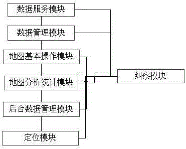
[0055] figure 1 Schematic diagram of the structure of the geographical information data comprehensive management system provided for this embodiment, as figure 1As shown, a geographic information data comprehensive management system, wherein the system includes a data service module, a data management module, a basic map operation module, a map analysis and statistics module, a background data management module, a picket module and a positioning module, wherein: the The data service module integrates and analyzes the data of different service forms, uploads and locates the plot information to the map, and transmits the relevant service data to the map; the data management module displays the graphic results based on 2D and 3D geographic information data Management, merging 2D and 3D graphics data, and presenting multi-dimensional synchronous three-dimensional display of plot data through the display device for 2D and 3D data; the basic map operation module is based on spatial ...

Embodiment 2

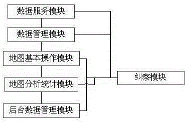
[0124] figure 2 Schematic diagram of the structure of the geographical information data comprehensive management system provided for this embodiment, as figure 2As shown, a geographic information data comprehensive management system, wherein the system includes a data service module, a data management module, a map basic operation module, a map analysis and statistics module, a background data management module, and a picket module, wherein: the data service module Integrate and analyze the data of different service forms, upload and locate the land plot information to the map, and transmit the relevant service data to the map; the data management module manages the display and management of graphic results based on 2D and 3D geographic information data. 2. Fusion of three-dimensional graphics data, and displaying multi-dimensional synchronous three-dimensional display of land plot data through the display device for two-dimensional and three-dimensional data; the basic map ...

Embodiment 3

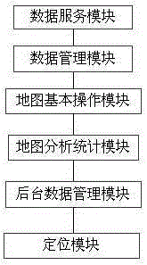
[0187] image 3 Schematic diagram of the structure of the geographical information data comprehensive management system provided for this embodiment, as image 3 As shown, a geographic information data comprehensive management system, wherein the system includes a data service module, a data management module, a map basic operation module, a map analysis and statistics module, a background data management module and a positioning module, wherein: the data service module Integrate and analyze the data of different service forms, upload and locate the land plot information to the map, and transmit the relevant service data to the map; the data management module manages the display and management of graphic results based on 2D and 3D geographic information data. 2. Fusion of three-dimensional graphics data, and displaying multi-dimensional synchronous three-dimensional display of land plot data through the display device for two-dimensional and three-dimensional data; the basic m...


PUM


Abstract

The invention discloses an integrated management system of geographic information data, and belongs to the geographic information technology. The system is characterized in comprising a data service module, a data management module, a basic operation module of a map, a map analysis and statistics module and a background data management module, wherein the data service module integrates, analyzes and transmits data of different service forms into the map; the data management module carries out graph management and fusion on two-dimensional and three-dimensional geographic information data; the basic operation module of the map carries out display control on a layer of each dimension on the basis of spatial data; on the basis of the spatial data, the map analysis and statistics module carries out overlay analysis; and the background data management module updates the spatial data in fixed time to perfect the spatial data. The integrated management system has the advantages that the multi-source data, including the spatial data, business data, attribute data, basic base map data and the like, can be effectively fused, and data processing and application can be effectively combined and applied.

Description

technical field [0001] The present invention relates to the technical field of geographic information, specifically an effective combination and application of multi-source data such as spatial data, business data, attribute data, and basic base map service numbers, processing and application methods, It is a geographic information data comprehensive management system that can integrate data processing, analysis, positioning, and multi-source data application and display into one intelligent information transmission. Background technique [0002] There are two understandings of smart city, narrow sense and broad sense. In a narrow sense, a smart city refers to a city based on the Internet of Things, through the interconnection of things, interconnection, and intelligence, so that various functions in the city can be coordinated with each other, with a high degree of integration of smart technology, high-end development of smart industries, and efficient and convenient smart ...

Claims


Application Information

Patent Timeline
IPC IPC(8): G06F17/30
CPCG06F16/25G06F16/21G06F16/29
Inventor 毛继国杨文博王贺朋任建建王力
Owner 星际空间(天津)科技发展有限公司
Why Eureka
Try Eureka