A Fast Denoising Method for Radar Data Based on Space Modeling Technology

A technology of radar data and radar equations, applied in the direction of radio wave reflection/re-radiation, instruments, measuring devices, etc., can solve the problem of incompatibility between denoising effect and characteristic information preservation effect, and achieve good operability and applicability performance, eliminate speckle noise, and suppress noise

Active Publication Date: 2019-06-18
BEIJING RES INST OF URANIUM GEOLOGY
View PDF4 Cites 0 Cited by
  • Summary
  • Abstract
  • Description
  • Claims
  • Application Information

AI Technical Summary

Problems solved by technology

[0005] The technical problem to be solved in the present invention is: the denoising effect and the feature information preservation effect of the existing radar data noise removal method cannot be achieved at the same time

Method used


Image

  • A Fast Denoising Method for Radar Data Based on Space Modeling Technology
  • A Fast Denoising Method for Radar Data Based on Space Modeling Technology
  • A Fast Denoising Method for Radar Data Based on Space Modeling Technology

Examples


Embodiment Construction

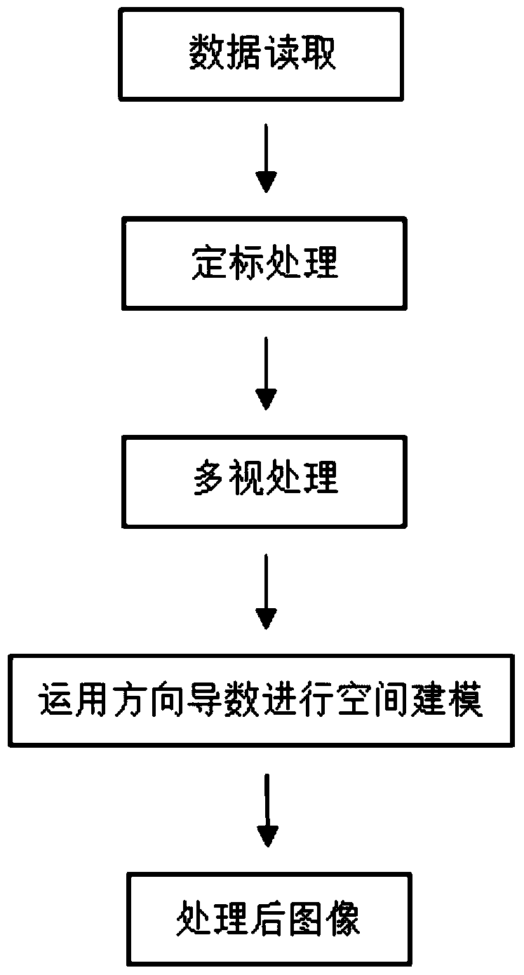
[0040] A method for rapid denoising of radar data based on space modeling technology according to the present invention will be described in detail below with reference to the drawings and embodiments.

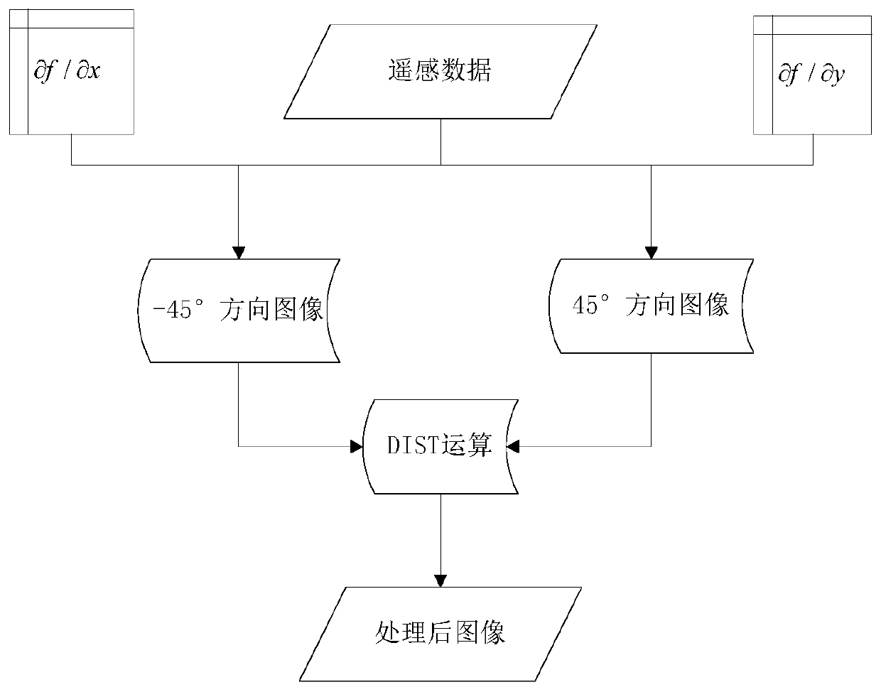
[0041] like figure 1 As shown, a rapid denoising method for radar data based on space modeling technology of the present invention reads radar data such as Radarsat-2, successively performs calibration processing and multi-view processing, and then uses multi-directional reciprocal operations to perform filtering to achieve denoising. noise. Specifically include the following steps:

[0042] Step 1. Data reading

[0043] To read radar data such as Radarsat-2 satellite data, in this embodiment, the radar data format is a geographic reference fine resolution product, the polarization mode is HV, and the working band is C band, that is, the wavelength is 5.6cm.

[0044] Step 2. Calibration processing

[0045] Obtaining local radar data through radar equations enables radar re...


PUM


Abstract

The invention belongs to the technical field of digital image processing and information extracting, and specifically relates to a rapid radar data de-noising method based on a spatial modeling technology. The method comprises the following steps: reading radar data; acquiring the radar brightness coefficient, the backward scattering coefficient and the backward scattering coefficient after normalization through a radar equation; when images are different in number of looks in the same scene, combining the images through multi-look processing; and importing the images to a space model, selecting small local areas of the images, calculating the derivative values of the center pixel value in the 45-degree and -45-degree directions, performing DIST operation on the two images after derivation operation, and synthesizing the two images into a new image. The technical problem that the existing radar data de-noising method cannot achieve a good de-noising effect and a good characteristic information maintaining effect at the same time is solved. Under the premise of maintaining geological radar scattering information to the maximum degree, the image edge or linear feature can be enhanced, and high-quality radar images can be provided for subsequent processing such as fusion and interpretation.

Description

technical field [0001] The invention belongs to the technical field of digital image processing and information extraction, and in particular relates to a rapid denoising method for radar data based on space modeling technology. Background technique [0002] Due to its unique imaging mechanism different from visible light and thermal infrared, microwave remote sensing has developed rapidly and is widely used in agricultural applications, disaster monitoring, surveying and mapping, atmospheric research and other fields. Imaging radar earth observation technology is widely used in geology such as structural analysis, regional geological mapping, lithology identification, and mineral deposit exploration, and has achieved a series of achievements and understandings. [0003] The side-view imaging method of SAR can enhance the geological structure distributed in a specific direction on the radar image. When the radar beam direction is perpendicular to the main linear structure di...

Claims


Application Information

Patent Timeline
Patent Type & Authority Patents(China)
IPC IPC(8): G01S7/41G01S13/89G01S13/90
CPCG01S7/414G01S13/89G01S13/90
Inventor 武鼎张杰林周觅郭帮杰
Owner BEIJING RES INST OF URANIUM GEOLOGY
Why Eureka
Try Eureka