Improved Mean Shift-based extraction method and system of road marking lines of Lidar (Light Detection And Ranging) point cloud data

A technology of road signs and point cloud data, applied in the field of GIS information, to achieve the effect of improving clustering accuracy and clustering efficiency

Active Publication Date: 2018-06-15
HUBEI UNIV
View PDF6 Cites 18 Cited by
  • Summary
  • Abstract
  • Description
  • Claims
  • Application Information

AI Technical Summary

Problems solved by technology

[0004] The present invention is mainly aimed at the problem of automatically extracting road marking lines based on laser radar point cloud data, and proposes a method for extracting road marking lines based on improved MeanShift Lidar point cloud data, so as to improve the accuracy and accuracy of automatic road marking line extraction from laser radar data. purpose of efficiency

Method used


Image

  • Improved Mean Shift-based extraction method and system of road marking lines of Lidar (Light Detection And Ranging) point cloud data
  • Improved Mean Shift-based extraction method and system of road marking lines of Lidar (Light Detection And Ranging) point cloud data
  • Improved Mean Shift-based extraction method and system of road marking lines of Lidar (Light Detection And Ranging) point cloud data

Examples


Embodiment

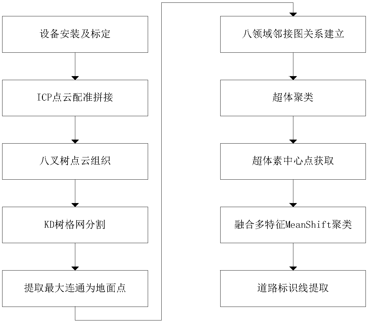
[0022] Such as figure 1 As shown, a road marking line extraction method based on improved MeanShift Lidar point cloud data, including the following steps:

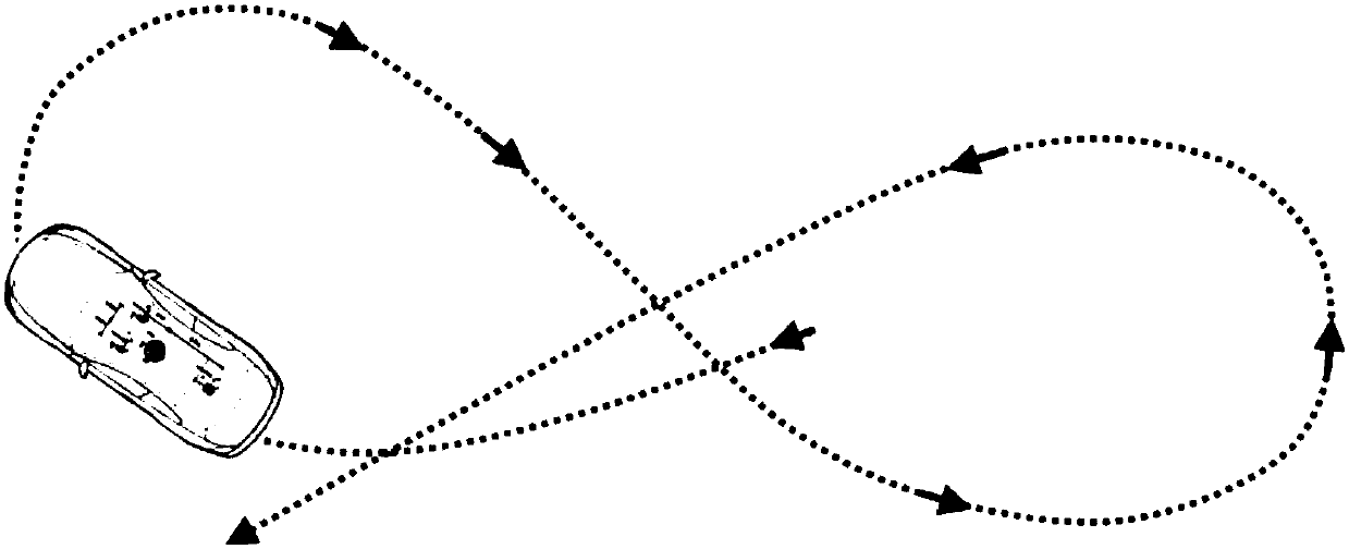
[0023] Step 1: Install a set of 32-line laser radar acquisition system on the top of the carrier vehicle, including GPS, inertial measurement device and camera, and calibrate the system through the method of 8-shaped calibration. The schematic diagram of the calibration scheme is as follows figure 2 As shown, collect and obtain vehicle-mounted lidar point cloud data;

[0024] Step 2, use the ICP calculation method for the lidar point cloud data in step 1 to register and stitch the multi-frame vehicle lidar point cloud data to reduce the system error;

[0025] Step 3, using the octree to reorganize the lidar point cloud data obtained in step 2, and obtain the coordinates of each grid center point;

[0026] Step 4, using the Kd tree structure to query the proximity value of the central point K obtained in step (3), and by...


PUM


Abstract

The invention relates to an extraction method of road marking lines, belongs to the field of GIS information technology, and particularly relates to an improved Mean Shift-based extraction method andsystem of road marking lines of Lidar (Light Detection And Ranging) point cloud data. According to the method, a vehicle-mounted Lidar collection system and an inertial measurement system are utilizedto acquire the road point cloud data, adjacency-graph relationships are established for the point cloud data through an octree, and supervoxel clustering is carried out; a Mean Shift algorithm fusedwith multiple features of intensity, normal vectors and the like is utilized to carry out road marking line extraction on the point cloud data; and road marking line points can be accurately extracted, the calculation amount of the Mean Shift algorithm is also greatly decreased at the same time, and thus the purpose of improving precision and efficiency of automated extraction of the road markinglines of the Lidar data is achieved.

Description

technical field [0001] The invention relates to a method for extracting road marking lines, belonging to the technical field of GIS information, in particular to a method and system for extracting road marking lines based on improved MeanShift-based Lidar point cloud data. Background technique [0002] LiDAR (Light Detection And Ranging, LiDAR) is an emerging technology that was first developed by western countries and put into commercial application in the early 1990s. It integrates laser range finder, global positioning system (GPS) and inertial measurement unit ( IMU) in one. This technology has made a major breakthrough in the real-time acquisition of three-dimensional spatial information, and provides a new technical means for obtaining spatial information with high temporal and spatial resolution. [0003] Roads play a pivotal role in transportation, urban planning, "smart cities" and other fields, and road marking lines, as the most important item of road information...

Claims


Application Information

Patent Timeline
Patent Type & Authority Applications(China)
IPC IPC(8): G06K9/00G06K9/62G06T7/00
CPCG06T7/0002G06T2207/10028G06T2207/30256G06V20/588G06F18/23213G06F18/22
Inventor 张良周佳雯张谦张帆范媛媛
Owner HUBEI UNIV
Why Eureka
Try Eureka