Remote control measurement method for underwater topography of low drainage pool

A measurement method and underwater terrain technology, applied in measurement devices, mapping and navigation, instruments, etc., to meet individual needs, avoid drowning accidents, and improve work efficiency.

Active Publication Date: 2018-06-29
THE 404 COMPANY LIMITED CHINA NAT NUCLEAR
View PDF11 Cites 3 Cited by
  • Summary
  • Abstract
  • Description
  • Claims
  • Application Information

AI Technical Summary

Problems solved by technology

[0003] In order to solve the problem of remote measurement of underwater terrain in low-release pools, ensure the radiation safety of staff, and protect the occupational health of employees, the invention proposes a remote-control measurement method for underwater terrain in low-release pools

Method used


Image

  • Remote control measurement method for underwater topography of low drainage pool

Examples


Embodiment Construction

[0023] The present invention will be described in detail below in conjunction with specific embodiments.

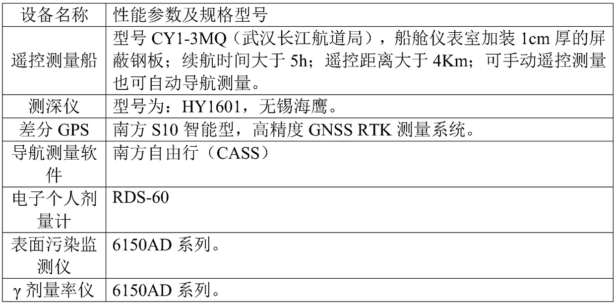
[0024] The overall technical scheme of the present invention is as follows: carry out radioactive survey on the surrounding area of ​​the low-release pool in advance, select suitable personnel operating points according to the principle of radiation protection optimization combined with the data of radioactive survey, formulate a radiation protection plan, and then carry out underwater terrain survey . Personnel operate the remote-controlled survey ship equipped with water depth gauges and differential GPS, and the remote-controlled survey ship patrols and measures the depth of the pool water according to the preset route. Through surveying, the water depth meter obtains the water depth data on each route measurement point, and the differential GPS obtains the GPS coordinate data on each route measurement point. In the case of knowing the elevation coordinates of the bot...


PUM


Abstract

The invention belongs to the technical field of decommissioning disposal of nuclear facilities, and specifically relates to a remote control measurement method for the underwater topography of a low drainage pool. For the characteristic that the low drainage pool is of certain radioactivity and large investigation area, radioactive general investigation is carried out on the periphery of the low drainage pool before measurement, and a radiation protection scheme is established, so that the radiation safety of people is guaranteed; efficient, convenient and safe underwater topography measurement measures in combination with equipment such as RTK GPS, a depth finder and a remote control measurement boat are proposed; the depth finder is used for carrying out water depth detection, and compared with traditional water depth measurement ways such as a measurement hammer and a probe, the work efficiency is improved; the remote control measurement boat can be used for patrolling according toan established ship route, so that the water area water depth data is obtained, and synchronous measurement of measurement point water depth data and GPS coordinate point data is realized; and throughremote control operation of the remote control boat, the radiation damage of people is effectively reduced, the radiation safety of people is guaranteed, the operation safety is further improved, andthe occurrence of drowning accidents of people is avoided.

Description

technical field [0001] The invention belongs to the technical field of decommissioning treatment of nuclear facilities, and in particular relates to a remote-controlled measurement method for underwater topography in low-release pools. Background technique [0002] Underwater topographic measurement of low-release pools is currently used in China as follows: first plan the location of the depth measurement point in the low-release pool, and then use GPS to determine the coordinates of the measurement point, and then measure the depth of the coordinate point. Data collection generally uses the following methods: (1) measuring the water depth with a measuring rod; (2) measuring the depth with a mound or a rope. Finally, the water depth data and coordinate values ​​are combined, and the topography of the low-release pool is obtained statistically. The disadvantages of the traditional method are: (1) Measuring the water depth with the measuring rod can generally meet the requir...

Claims


Application Information

Patent Timeline
Patent Type & Authority Applications(China)
IPC IPC(8): G01C7/00
CPCG01C7/00
Inventor 戴晓姝于红箭付云杉朱盈喜陈春生秦川李雄谈建平张鸿孙惠东桑亚平
Owner THE 404 COMPANY LIMITED CHINA NAT NUCLEAR
Why Eureka
Try Eureka