Image control point target system and method for unmanned aerial vehicle measurement and airborne laser radar

An airborne laser radar and laser radar technology, applied in the field of surveying and mapping, to achieve the effect of ensuring accuracy, good ground image control point requirements, and image registration accuracy

Pending Publication Date: 2020-05-08
SOUTHWEST JIAOTONG UNIV
View PDF10 Cites 3 Cited by
  • Summary
  • Abstract
  • Description
  • Claims
  • Application Information

AI Technical Summary

Problems solved by technology

[0003] The purpose of the present invention is to solve the problem of image control point selection for surveying and mapping, and propose a system and method for image control point targeting of unmanned aerial vehicle measurement and airborne laser radar

Method used


Image

  • Image control point target system and method for unmanned aerial vehicle measurement and airborne laser radar
  • Image control point target system and method for unmanned aerial vehicle measurement and airborne laser radar
  • Image control point target system and method for unmanned aerial vehicle measurement and airborne laser radar

Examples


Embodiment Construction

[0026] Embodiments of the present invention will be further described below in conjunction with the accompanying drawings.

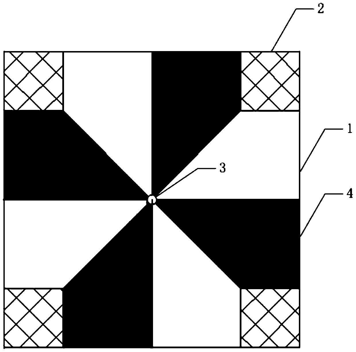
[0027] Such as figure 1 As shown, the present invention provides an image control point target system for UAV measurement and airborne laser radar, including a target panel 1, a laser radar launch target 2, a center bolt hole 3 and a center mark target 4; The target panel 1 is square; the laser radar emission target 2 is fixedly arranged at the four corners of the target panel 1; the central bolt hole 3 is fixedly arranged at the center of the target panel 1; the central mark target 4 and the central bolt hole 3 are fixedly connected , and evenly fixed on the target panel 1 .

[0028] In the embodiment of the present invention, such as figure 1 As shown, the material of the target panel 1 is aluminum alloy, its size is 50cm×50cm, and its thickness is 0.5cm. In the present invention, the target panel made of aluminum alloy has a strong reflection funct...


PUM


Abstract

The invention discloses an image control point target system and a method for unmanned aerial vehicle measurement and airborne laser radar. The image control point target system comprises a target panel, laser radar transmitting targets, a center bolt hole and a center mark target. The laser radar transmitting targets are fixedly arranged at four corners of the target panel; the central bolt holeis fixedly formed in the central position of the target panel; and the central mark targets and the central bolt holes are fixedly connected and are uniformly and fixedly arranged on the target panel.The image control point target system is simple in structure, easy to manufacture and low in requirement for the operation environment, and basically meets the requirement for terrain operation. Theimage control point target method is easy to operate, the workload is reduced, the operation efficiency is improved, and the image control point target method can be used as an image control point forunmanned aerial vehicle photogrammetry and airborne laser radar photogrammetry at the same time and is dual-purpose.

Description

technical field [0001] The invention belongs to the technical field of surveying and mapping, and in particular relates to an image control point target system and method for unmanned aerial vehicle measurement and airborne laser radar. Background technique [0002] At present, the UAV aerial photography system is a useful supplement to the traditional aerial photogrammetry technology. It can operate in harsh environments and high-risk areas, especially in small and complex areas, and areas with complex landforms and meteorological conditions. It fully embodies the characteristics of UAV remote sensing, such as flexibility and wide application range. With the development in recent years, UAV photogrammetry technology has become an important technical means for resource and environment investigation, real-time monitoring of emergencies, disaster prediction and assessment, etc., and plays an important role in aerial photogrammetry. Airborne lidar is a new type of active obser...

Claims


Application Information

Patent Timeline
Patent Type & Authority Applications(China)
IPC IPC(8): G01C11/02G01S17/894
CPCG01C11/02G01S17/89
Inventor 张瑞庞家泰段金亮余斌廖明杰
Owner SOUTHWEST JIAOTONG UNIV
Why Eureka
Try Eureka