Three-dimensional cooperative positioning method for unmanned aerial vehicle group

A technology for co-location and unmanned aerial vehicles, applied in satellite radio beacon positioning systems, radio wave measurement systems, instruments, etc., can solve problems such as high price and limited application, and achieve improved positioning accuracy, simple hardware implementation, and distance measurement. Error insensitive effect

Active Publication Date: 2020-05-08
XIDIAN UNIV +1
View PDF6 Cites 11 Cited by
  • Summary
  • Abstract
  • Description
  • Claims
  • Application Information

AI Technical Summary

Problems solved by technology

The GPS augmentation system can provide high positioning accuracy, but it is expensive, which limits its application in UAV swarm positioning

Method used


Image

  • Three-dimensional cooperative positioning method for unmanned aerial vehicle group
  • Three-dimensional cooperative positioning method for unmanned aerial vehicle group
  • Three-dimensional cooperative positioning method for unmanned aerial vehicle group

Examples


Embodiment Construction

[0017] The embodiments and effects of the present invention will be described in further detail below with reference to the accompanying drawings.

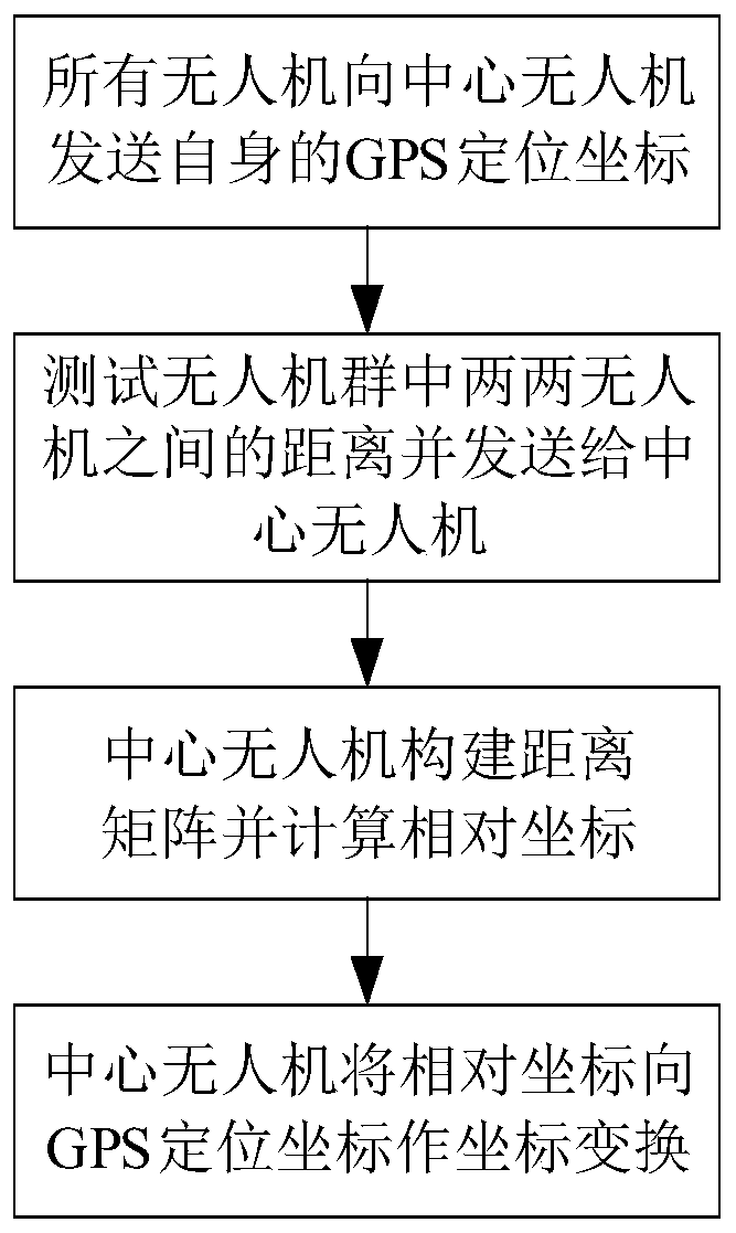
[0018] Reference figure 1 , The implementation steps of this embodiment are as follows:

[0019] Step 1. All drones send their GPS positioning coordinates to the central drone.

[0020] All drones in the drone swarm are equipped with GPS global positioning system, which can obtain their own real-time position coordinates through satellites, and all drones are equipped with communication modules, which can realize communication between any two drones. There is a central drone in the drone swarm, which is equipped with a computing chip. It has certain computing capabilities and can undertake the calculation tasks of the entire drone swarm.

[0021] All drones in the drone swarm send their GPS positioning coordinates G to the central drone undertaking the calculation task, where G={g i }, g i Is the GPS positioning coordinates of the i-th U...


PUM


Abstract

The invention discloses a three-dimensional cooperative positioning method for an unmanned aerial vehicle group, and mainly solves the problems that an existing method only adopts a GPS to position the unmanned aerial vehicle group, and the positioning error is large. According to the scheme, the method comprises the steps of: allowing all unmanned aerial vehicles in an unmanned aerial vehicle group to send GPS positioning coordinates of the unmanned aerial vehicles to a central unmanned aerial vehicle undertaking a calculation task; testing the distance between every two unmanned aerial vehicles in the unmanned aerial vehicle group, and sending the measured distance information to the central unmanned aerial vehicle; allowing the central unmanned aerial vehicle to construct the received distance information into a distance matrix, and obtaining the relative coordinates of all the unmanned aerial vehicles in the unmanned aerial vehicle group by adopting a multi-dimensional scale analysis algorithm according to the distance matrix; and allowing the central unmanned aerial vehicle to convert the relative coordinates into GPS positioning coordinates by adopting a least square principle, calculate the absolute coordinates of the unmanned aerial vehicles, and send the absolute coordinates to the whole unmanned aerial vehicle group. The method can reduce the GPS positioning error, accurately estimates the position of the unmanned aerial vehicle, and can be used for the unmanned aerial vehicle group to cooperatively complete the path planning of express transportation, disaster monitoring, agricultural production, formation performance and combat tasks.

Description

Technical field [0001] The invention belongs to the technical field of unmanned aerial vehicles, and specifically relates to a positioning method, which can be used to coordinately complete the path planning of express transportation, disaster monitoring, agricultural production, formation performance and combat missions by an unmanned aerial vehicle group. Background technique [0002] At this stage, the development of drone technology has led to a rapid increase in the market demand for drones. UAVs were originally used in the military field. Because of their low cost, small size, and strong maneuverability, UAVs have become indispensable weapons and equipment for information operations. They play an important role in military reconnaissance, monitoring, and strikes. Later, with the development of drone technology, drones began to be widely used in civilian fields, including express transportation, disaster monitoring, agricultural production, and formation performances. Due t...

Claims


Application Information

Patent Timeline
Patent Type & Authority Applications(China)
IPC IPC(8): G01S19/51
CPCG01S19/51
Inventor 陈睿杨彬郭彦涛闫继垒周啸天
Owner XIDIAN UNIV
Why Eureka
Try Eureka