Special instrument for geographic surveying and mapping,, surveying and mapping method and application

A special instrument and geography technology, applied in the field of surveying and mapping, can solve the problem of not comprehensively realizing the monitoring data of measurement points and landform images, soil composition and altitude report information collection, storage, query, summary, analysis and map display, surveying and mapping results. Inaccurate and incapable of large-scale use, etc., to enrich monitoring image information, improve monitoring experience, and save costs

Pending Publication Date: 2020-06-19
CHONGQING VOCATIONAL INST OF ENG
View PDF6 Cites 0 Cited by
  • Summary
  • Abstract
  • Description
  • Claims
  • Application Information

AI Technical Summary

Problems solved by technology

[0005] To sum up, the problems existing in the existing technology are: (1) The existing system does not comprehensively realize the collection, storage, query, summary, analysis and map display of the monitoring data of the measurement points and the topographic image, soil composition and altitude report information and other functions
[0006] (2) The original surveying and mapping method, through manual single-point measurement, integrates the measured information together. This method is slow to process, and manual processing is prone to information deviation, resulting in inaccurate surveying and mapping results.
[0007] (3) The method for automatic identification of geographical names in the prior art has huge system, complex configuration, high cost, poor replaceability, and cannot be used on a large scale

Method used


Image

  • Special instrument for geographic surveying and mapping,, surveying and mapping method and application
  • Special instrument for geographic surveying and mapping,, surveying and mapping method and application
  • Special instrument for geographic surveying and mapping,, surveying and mapping method and application

Examples


Embodiment Construction

[0062] In order to make the object, technical solution and advantages of the present invention more clear, the present invention will be further described in detail below in conjunction with the examples. It should be understood that the specific embodiments described here are only used to explain the present invention, not to limit the present invention.

[0063] Aiming at the problems existing in the prior art, the present invention provides a special instrument for geographic surveying and mapping, a surveying and mapping method and its application. The present invention will be described in detail below in conjunction with the accompanying drawings.

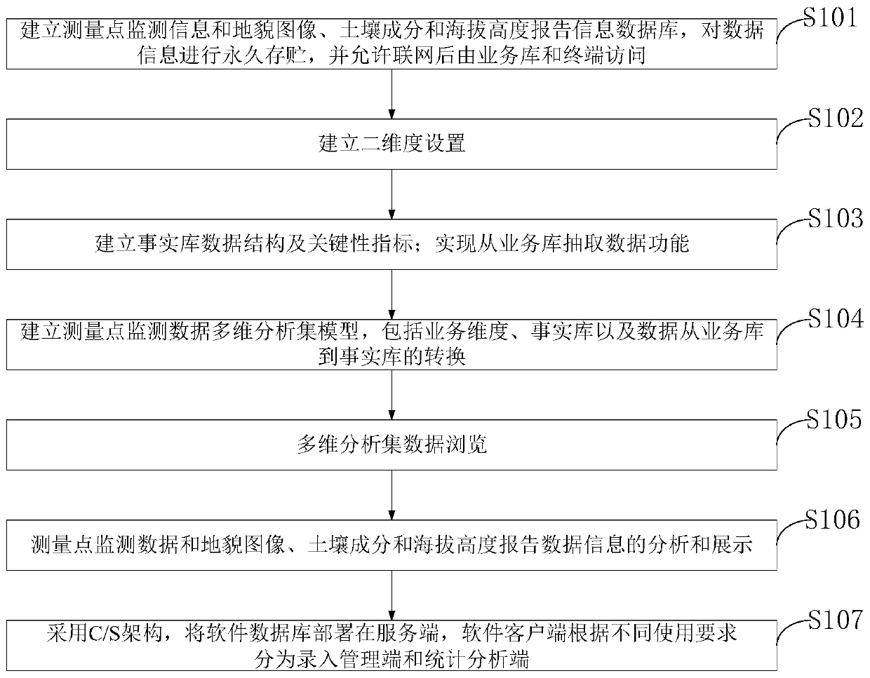
[0064] Such as figure 1 As shown, the geographic surveying and mapping special instrument surveying and mapping method that the embodiment of the present invention provides, comprises the following steps:

[0065] S101. Establish a database of measurement point monitoring information and landform images, soil composition and...


PUM


Abstract

The invention belongs to the technical field of surveying and mapping, and discloses a special instrument for geographic surveying and mapping, a surveying and mapping method and application. The method includes: establishing a database of measurement point monitoring information and geomorphic images, soil components and altitude report information, and permanently store data information; establishing a two-dimensional setting; a function of extracting data from a service library is realized; establishing a measurement point monitoring data multi-dimensional analysis set model; analyzing anddisplaying measurement point monitoring data, landform images, soil components and altitude report data information; and deploying the software database at a server. According to the invention, a large amount of measurement point monitoring and geomorphic image, soil component and altitude report information data information can be collected and stored, and precious data information is provided for formulating a measurement point prevention and control strategy, early warning and prediction of geomorphic images, soil components and altitude, and assessment and identification of control and elimination of measurement points in the future.

Description

technical field [0001] The invention belongs to the technical field of surveying and mapping, and in particular relates to a special instrument for geographic surveying and mapping, a surveying and mapping method and its application. Background technique [0002] Currently, surveying is all about measuring and drawing. Based on PC technology, photoelectric technology, network communication technology, space science, and information science, the existing feature points and boundaries on the ground are measured to obtain graphics and position information that reflect the current situation of the ground for planning, design and administration of engineering construction. For administrative purposes. [0003] Geographical identification technology has been more and more used in various industries, and the development of geographical identification in the field of video surveillance is also getting faster and faster. The existing geographic identification technology needs the f...

Claims


Application Information

Patent Timeline
Patent Type & Authority Applications(China)
IPC IPC(8): G06F16/29G06F16/26G01C15/00G01N33/24
CPCG06F16/29G06F16/26G01C15/00G01N33/24
Inventor 李天和
Owner CHONGQING VOCATIONAL INST OF ENG
Why Eureka
Try Eureka