A rapid yield estimation method for large-area Camellia oleifera forests based on UAV remote sensing

A Camellia oleifera forest, large-scale technology, applied in neural learning methods, photo interpretation, computer parts and other directions, can solve problems such as low feasibility, slow speed, large human, material and financial resources, and achieve high data acquisition efficiency and portability. The effect of strong sexuality and low image cost

Active Publication Date: 2021-11-30
湖南三湘绿谷生态科技有限公司 +1
View PDF8 Cites 0 Cited by
  • Summary
  • Abstract
  • Description
  • Claims
  • Application Information

AI Technical Summary

Problems solved by technology

[0006] (1) Due to the lack of sufficient attention, the traditional production estimation of camellia oleifera mostly relies on manual picking and weighing. This method consumes a lot of manpower, material and financial resources, and it is easy to introduce manual errors in the operation process
[0007] (2) Among the existing yield estimation methods of Camellia oleifera forest, the method of artificial yield estimation has poor flexibility, slow speed, and is not suitable for large-scale rapid yield estimation
[0008] (3) The existing methods for estimating the yield of camellia oleifera forests are costly, and they are powerless to quickly estimate the yield of camellia oleifera forests in large-scale hilly areas. In order to obtain the yield estimation parameters of camellia oleifera forests in different growth periods, multiple field investigations are required, and the feasibility is low
[0009] (4) In the prior art, there are few research reports on rapid yield estimation of Camellia oleifera forests based on UAV remote sensing
[0010] The difficulty in solving the above problems and defects is: the high-definition and mobility of UAVs make it possible to quickly estimate the yield of Camellia oleifera forests in large areas, but the sample size of ultra-low-altitude aerial photography of UAVs directly affects the accuracy of rapid yield estimation of Camellia oleifera forests
If the sample size is too small, the output estimation model constructed will not be representative; if the sample size is too large, it will increase the field workload, economic cost and battery consumption of UAV automatic aerial photography

Method used


Image

  • A rapid yield estimation method for large-area Camellia oleifera forests based on UAV remote sensing
  • A rapid yield estimation method for large-area Camellia oleifera forests based on UAV remote sensing
  • A rapid yield estimation method for large-area Camellia oleifera forests based on UAV remote sensing

Examples


Embodiment 1

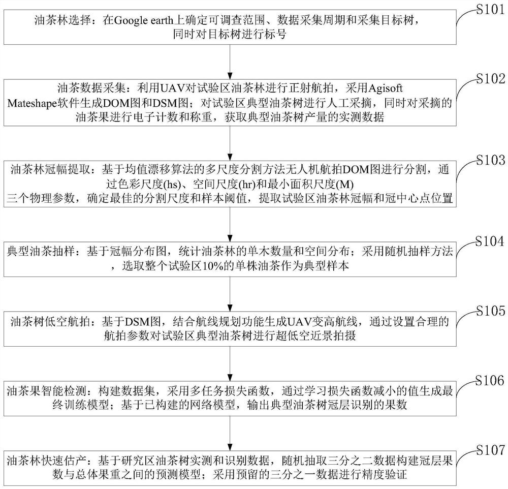
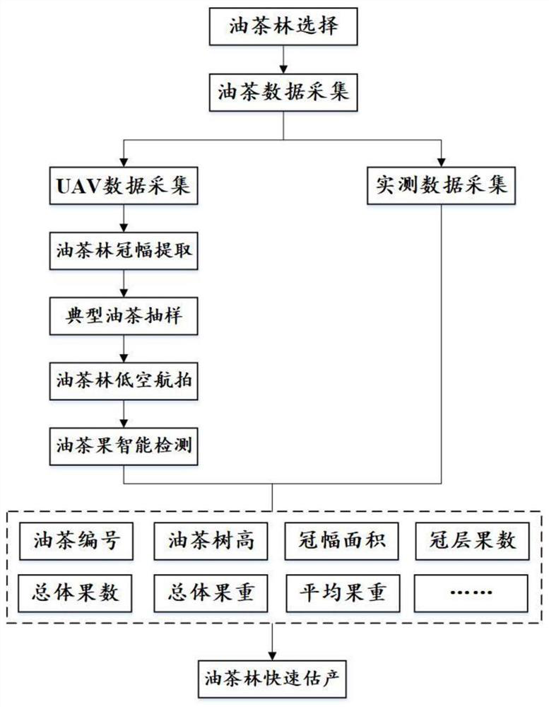
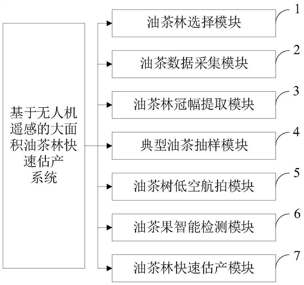
[0098] The method for quickly estimating the output of large-area Camellia oleifera forests based on remote sensing of UAVs provided by the present invention belongs to the field of intelligent monitoring of economic forests. The method is suitable for rapid production estimation of most economic forest tree species, and the specific steps are as follows:

[0099] 1. Scheme design

[0100] First select the research area, then determine the scope of investigation, data collection cycle, collection target tree on Google earth, and label the target tree at the same time.

[0101] 2. Camellia oleifera data collection

[0102] UAV data collection: Before the UAV takes off, hardware, software and UAV GPS signal inspection should be carried out. UAV was used to take orthographic aerial photography of Camellia oleifera forest in the test area, and Agisoft Mateshape software was used to generate DOM and DSM maps.

[0103] Measured data collection: Combined with the actual situation, ...

Embodiment 2

[0118] 1. Data collection

[0119] The test area of ​​this implementation case is located in Jiang Village, Chenjiafang Town, Xinshao County, in the central part of Hunan Province, between the Shaoyang Basin and the Xinlian Basin. It is a typical low hill in the south, located at 111°05′-111°08′E and Between 27°15' and 27°38'. The shooting equipment is a DJI Mavic 2Pro UAV. The weather on the day of aerial photography is sunny, the light is sufficient, and the image quality is good; in this case, 120 Camellia oleifera trees were manually picked on the spot, and the number, tree height, total fruit number and total fruit weight of the camellia oleifera trees were measured and recorded .

[0120] 2. Data processing

[0121] In this case, the image size of the orthographic aerial stitching is 55639pixel×54264pixel, the pixel size is 0.0275m×0.0275m, the height of the aerial photography is 100m, and the speed is 5m / s; Figure 4 .

[0122] 3. Camellia oleifera fruit count

[0...


PUM


Abstract

The invention belongs to the technical field of intelligent monitoring of economic forests, and discloses a method for quickly estimating the yield of a large-area camellia oleifera forest. The method for rapidly estimating the yield of a large-area camellia oleifera forest based on remote sensing of a drone includes: selection of camellia oleifera forest; data collection of camellia oleifera forest; extraction of camellia oleifera forest crown; typical Camellia oleifera sampling; low-altitude aerial photography of camellia oleifera forest; intelligent detection of camellia oleifera fruit; rapid production estimation of camellia oleifera forest. The present invention is based on the unmanned aerial vehicle aerial photography technology, carries out the large-area Camellia oleifera forest rapid production estimation, fills the gap of domestic Camellia oleifera forest rapid production estimation. The low-altitude UAV aerial photography of the present invention has the characteristics of flexible operation, high data acquisition efficiency, low image cost, and strong timeliness, and can quickly obtain the spatial distribution information of Camellia oleifera forest in the test area; the present invention has fast, non-destructive, high accuracy, The advantage of large scale; it can realize the rapid detection, counting and evaluation of the yield data of camellia oleifera forest, and has the potential to be applied to the rapid production estimation of large-area camellia oleifera forest.

Description

technical field [0001] The invention belongs to the technical field of intelligent monitoring of economic forests, and in particular relates to a method and system for quickly estimating the production of large-area camellia oleifera forests based on remote sensing of drones. Background technique [0002] At present, camellia oleifera, as a unique woody oil tree species in southern my country, is known as the world's four largest woody edible oil plants together with oil palm, olive and coconut, and plays an important role in the regional economy. With the development of the economy, the planting area of ​​camellia oleifera forest has been expanding year by year, and the rapid production estimation of camellia oleifera forest has great practical significance for ensuring the safety of grain and oil and the development of oil industry. However, due to the lack of sufficient attention, traditional Camellia oleifera forest yield estimates mostly rely on manual picking and weigh...

Claims


Application Information

Patent Timeline
Patent Type & Authority Patents(China)
IPC IPC(8): G06K9/00G06K9/32G06K9/62G06N3/08G06Q50/02G01C11/04
CPCG06N3/08G06Q50/02G01C11/04G06V20/188G06V10/25G06F18/241G06F18/214
Inventor 莫登奎严恩萍尹显明棘玉文东新夏瑞聪熊君廖健
Owner 湖南三湘绿谷生态科技有限公司
Why Eureka
Try Eureka