Urban tree three-dimensional visualization method based on vehicle-mounted laser point cloud data

A point cloud data, vehicle-mounted laser technology, applied in image data processing, 3D modeling, instruments, etc., can solve triangular patch data and information loss, can not simultaneously smooth surface and repair holes, can not capture and reconstruct the surface well Local details and other issues can be avoided to avoid inaccurate expression of morphological features

Pending Publication Date: 2022-03-25
YANGTZE DELTA REGION INST OF UNIV OF ELECTRONICS SCI & TECH OF CHINE HUZHOU
View PDF0 Cites 2 Cited by
  • Summary
  • Abstract
  • Description
  • Claims
  • Application Information

AI Technical Summary

Problems solved by technology

The greedy projection triangulation algorithm first projects the point cloud to a certain plane through the normal line, establishes the topological relationship between the point clouds on the two-dimensional plane, and finally obtains the three-dimensional triangular mesh surface model, but this method cannot simultaneously smooth the surface and Hole repair; the moving cube algorithm approximates the isosurface by linear interpolation in the three-dimensional discrete data field, but after reconstruction, it will contain a large amount of triangular patch data and the information will be seriously lost; Poisson reconstruction constructs Poisson by smoothing the filter indicator function The equation establishes the relationship between the gradient field of the indicator function after surface filtering and the inward normal vector field of the surface, and solves the isosurface, but it cannot capture the local details of the reconstructed surface well.

Method used


Image

  • Urban tree three-dimensional visualization method based on vehicle-mounted laser point cloud data
  • Urban tree three-dimensional visualization method based on vehicle-mounted laser point cloud data
  • Urban tree three-dimensional visualization method based on vehicle-mounted laser point cloud data

Examples


Embodiment Construction

[0031] The present invention will be described in further detail below through the implementation of a sample and in conjunction with the accompanying drawings. The development environment of this example is Microsoft Visual Studio 2019, the external library PCL1.12.0, and the programming language C++.

[0032] A method for three-dimensional visualization of urban trees based on vehicle-mounted laser point cloud data, comprising the following steps:

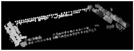
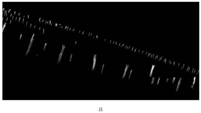
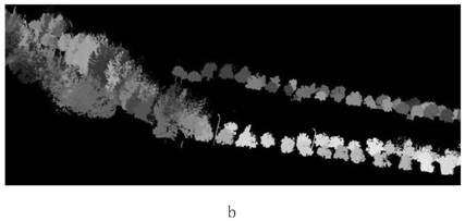
[0033] Step 1. Take the vehicle-mounted laser point cloud data of a certain school as an example to carry out 3D visualization of urban trees. The data is obtained by using the SSW-2 vehicle-mounted laser scanner. The point cloud includes all the feature information obtained by the vehicle system, such as the ground, street trees, Buildings, green belts, basic public facilities, etc. Street trees include independent street trees and connected street trees, and the point cloud density is an average of 201 points / m2. The cloudcomp...


PUM


Abstract

The invention belongs to the technical field of vehicle-mounted laser radar point cloud data processing, and particularly relates to an urban tree three-dimensional visualization method based on vehicle-mounted laser point cloud data. Based on original point cloud data, after tree segmentation and crown and trunk separation, tree trunks and crowns are modeled independently, and finally a tree three-dimensional model in an urban scene is constructed. Compared with a traditional tree three-dimensional modeling method, independent modeling can be carried out according to different morphological characteristics of trunks and crowns, the defect that morphological characteristic expression of single-tree modeling is not accurate is avoided, the urban tree three-dimensional model can be simply, rapidly and accurately constructed, and the method can be applied to forestry resource investigation and 3D urban modeling and has a wide application prospect. Tree parameter extraction and the like.

Description

technical field [0001] The invention belongs to the technical field of vehicle-mounted laser radar point cloud data processing, and in particular relates to a three-dimensional visualization method for urban trees based on vehicle-mounted laser point cloud data. Background technique [0002] Lidar is an active remote sensing device that breaks through the traditional single-point measurement method and measures the distance between the sensor and the target object by actively emitting laser pulses. With the unique advantages of high precision, high resolution, and high efficiency, it can quickly obtain topographic information through the forest vegetation covered by the ground, providing a new technical means for the extraction of forest structure parameters and three-dimensional visualization of trees. [0003] Vegetation models such as trees are an indispensable and important part of urban scene modeling. At the same time, the three-dimensional tree model is also a very r...

Claims


Application Information

Patent Timeline
Patent Type & Authority Applications(China)
IPC IPC(8): G06T17/20G06T7/11G06T5/00
CPCG06T17/20G06T7/11G06T5/002
Inventor 李世华赵顺达尤航凯
Owner YANGTZE DELTA REGION INST OF UNIV OF ELECTRONICS SCI & TECH OF CHINE HUZHOU
Why Eureka
Try Eureka