Method for supporting continuous LOD drawing of GIS line object and surface object

An object and line segment technology, applied in the field of supporting continuous LOD drawing of GIS line objects and area objects, can solve the problems of low map visualization efficiency, unconsidered spatial index, etc., to meet the needs of rapid response, facilitate query and spatial operations, and improve query performance. The effect of efficiency

Active Publication Date: 2022-05-24
NANJING NORMAL UNIVERSITY
View PDF5 Cites 7 Cited by
  • Summary
  • Abstract
  • Description
  • Claims
  • Application Information

AI Technical Summary

Problems solved by technology

[0004] The purpose of the present invention is to solve the low efficiency of map visualization brought by the current large-scale vector data, and the spatial index does not consider the LOD scheduling of vector data, and provides a GPU-based element continuous LOD drawing method to achieve continuous LOD of line elements and area elements. performance rendering

Method used


Image

  • Method for supporting continuous LOD drawing of GIS line object and surface object
  • Method for supporting continuous LOD drawing of GIS line object and surface object
  • Method for supporting continuous LOD drawing of GIS line object and surface object

Examples


Embodiment 1

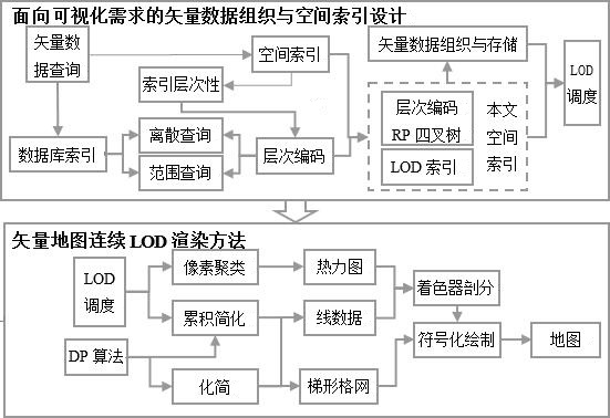
[0028] like figure 1 As shown, the continuous LOD rendering of road network map data in a certain range in my country includes the following steps:

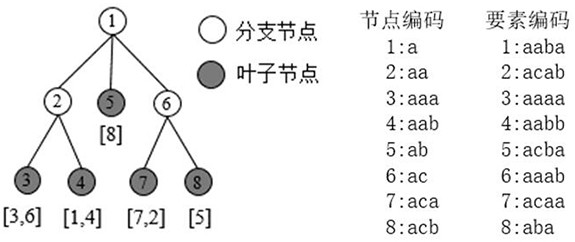
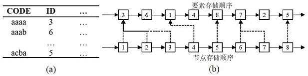
[0029] Step 1, initialize the spatial index with the point area quadtree, overload the access function of the index node and the data, and construct the hierarchical coding of the index node and its data through the range intersection query;

[0030] Step 2, first construct the trapezoidal grid structure of the surface elements separately, then improve the DP algorithm, iteratively calculate the weight value of each node of the element, and enter the weight value as incremental information into the database, and then construct the element data structure containing the weight value;

[0031] Step 3, according to the intersection relationship between the node bounding box and the visual query window, and the cumulative and simplified state of the node data, query incremental data from the database, and simplify or cumulatively simp...


PUM


Abstract

The invention discloses a method for supporting continuous LOD drawing of a GIS (Geographic Information System) line object and a surface object, which comprises the following steps of: initializing a spatial index by taking a point region quadtree as a prototype, and constructing a hierarchical code through range intersection query according to a hierarchical heavy-load index node of the spatial index and an access function of data; the method comprises the following steps: independently constructing a trapezoidal grid of surface elements, improving an algorithm, iteratively calculating the weight of each node, inputting the weight as incremental data into a database, and constructing an element data structure containing weight values; querying incremental data from a database according to information such as a topological relation between a node bounding box and a visual query window, a pixel scale and the like, and carrying out simplification or accumulative simplification on nodes; for a line, subdividing and rendering line elements from two parts of a line segment main body and a corner pattern; and for a surface, splitting the trapezoidal grid into trapezoidal chains by using a backbone trapezoid, and simplifying and rendering surface elements under the trapezoidal grid structure. According to the method, continuous LOD high-performance drawing of the line elements and the surface elements in the vector map can be realized.

Description

technical field [0001] The invention relates to the fields of geographic information system (GIS), computer aided design (CAD), computer cartography (CAC), navigation map, electronic map and mobile phone map, in particular to a method for continuous LOD drawing of GIS line objects and area objects. Background technique [0002] Map visualization has always been at the core of modern cartography, and the performance and quality of map visualization methods are of great importance for highly interactive mapping and analysis. The advent of the era of big data makes it difficult for current visualization methods to cope with the challenges of high map interactivity and data query and interaction brought about by the massiveness and complexity of vector data, and the multi-scale spatial indexing technology and LOD technology involved in vector data rendering. Research in this area is lacking. [0003] The multi-scale spatial indexing technique obtains data at different scales fo...

Claims


Application Information

Patent Timeline
Patent Type & Authority Applications(China)
IPC IPC(8): G06T11/20G06F16/22G06F16/29G06F16/51G06F16/56
CPCG06T11/206G06F16/29G06F16/2246G06F16/51G06F16/56Y02D10/00
Inventor 吴明光沈飞闾国年陈康正
Owner NANJING NORMAL UNIVERSITY
Why Eureka
Try Eureka