Post-processing of inverse DGPS corrections

a technology of inverse dgps and corrections, applied in surveying and navigation, navigation instruments, instruments, etc., can solve problems such as unjustified assumption

Inactive Publication Date: 2000-01-11
TRIMBLE NAVIGATION LTD
View PDF22 Cites 110 Cited by
  • Summary
  • Abstract
  • Description
  • Claims
  • Application Information

AI Technical Summary

Benefits of technology

This approach provides at least two major benefits. First, this approach requires only storage (optional), downloading and processing of as few as four (or three) location fix coordinate values, and the dynamic ranges of these coordinate values are usually limited to a few hundred kilometers or less. Thus, relatively few bits (as few as 16 per coordinate) are required for communication of the location fix coordinate information. Second, this approach uses the uncorrected mobile station location coordinates, with an estimated initial inaccuracy of no more than 30 meters, to determine the pseudorange corrections, rather than using the location coordinates of the reference station, which can be displaced from the mobile station by as much as a few hundred kilometers.

Problems solved by technology

This assumption may be unjustified if the local ionosphere and / or the local troposphere is undergoing relatively rapid change with time, or if the multipath signals that contribute to the pseudoranges at the two stations are substantially different.
Third, the variables actually determined are not the pseudoranges but the locations themselves.
First, this approach requires only storage (optional), downloading and processing of as few as four (or three) location fix coordinate values, and the dynamic ranges of these coordinate values are usually limited to a few hundred kilometers or less.
Second, this approach uses the uncorrected mobile station location coordinates, with an estimated initial inaccuracy of no more than 30 meters, to determine the pseudorange corrections, rather than using the location coordinates of the reference station, which can be displaced from the mobile station by as much as a few hundred kilometers.

Method used


Image

  • Post-processing of inverse DGPS corrections
  • Post-processing of inverse DGPS corrections
  • Post-processing of inverse DGPS corrections

Examples


Embodiment Construction

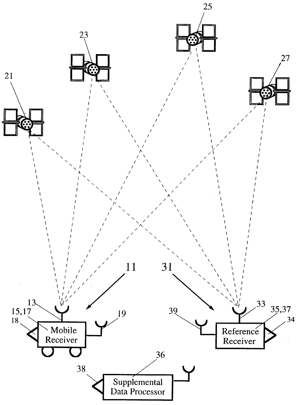
An SATPS mobile station 11 carries an SATPS signal antenna 13 and associated SATPS signal receiver / processor 15 and a mobile station downloader and associated port 18 (or transmitter and associated antenna) that are connected to the SATPS receiver / processor 15, in one embodiment of the invention shown in FIG. 1. The mobile station 11 receives SATPS signals from M (.gtoreq.4) SATPS satellites 21, 23, 25 and 27. Receipt of these signals allows the user to calculate the uncorrected, SATPS-determined present spatial location coordinates x.sub.unc, y.sub.unc, z.sub.unc and clock bias coordinate b.sub.unc, referred to as location fix coordinates (x,y,z,b).sub.unc, of the SATPS antenna 13 in a selected coordinate system. The spatial location coordinates (x,y,z) may be expressed in any coordinate system and are not limited to a Cartesian system. The mobile station downloader 18 permits downloading (or transmission) of the uncorrected location fix coordinates (x,y,z,b).sub.unc to an SATPS su...


PUM


Abstract

A method for enhancing the accuracy of location coordinates and / or clock bias computed for a mobile user station that is part of a Satellite Positioning System (SATPS), such as GPS or GLONASS. A data processing station is provided with pseudorange corrections PRC(t;j;ref) for an SATPS reference station for each of M SATPS satellites (j=1, . . . , M; M> / =3) and with uncorrected location fix coordinates x'(tf), y'(tf)', z'(tf)' and / or b'(tf) for the mobile station for a selected location fix time tf. A matrix equation H(tf;mob) DELTA W(tf;mob)=PRC(tf;ref) relates a matrix DELTA W of location fix coordinate corrections for the mobile station to a matrix PRC(t;ref) of the pseudorange correction values, where H(tf;mob) is an MxN matrix (M< / =N; N=3 or 4) with known entries computed from mobile station data. An inverse or pseudo-inverse matrix H(tf;mob)(-1) is formed satisfying the relation H(tf;mob)(-1)H(tf;mob)=the identity matrix I, and the matrix DELTA W(tf;mob)=H(tf;mob)(-1)PRC(tf;ref) is computed. The entries of the matrix DELTA W(tf) are interpreted as additive corrections for the location fix coordinates x'(tf), y'(tf)', z'(tf)' and / or b'(tf) for the mobile station. Post-processing can be performed to apply the pseudorange corrections to the mobile station data.

Description

BACKGROUND OF THE INVENTIONDevelopment of Satellite Positioning Systems (SATPSs), such as the Global Positioning System (GPS) in the United States and the Global Orbiting Navigational System (GLONASS) in the former Soviet Union, has allowed location coordinates of an object on or near the Earth to be determined with improved accuracy. Under ordinary circumstances, these location coordinates can be determined with an inaccuracy of no more than 30 meters. In order to further improve the accuracy provided by SATPS location determination, differential GPS (DGPS), and more generally differential SATPS (DSATPS), has been introduced and used. A DSATPS can provide locations with inaccuracies as low as a few meters, or lower in some instances. Implementation of a DSATPS requires that an SATPS reference station, whose location coordinates are known with high accuracy (to within a fraction of a meter) be provided to receive the normal SATPS signals from an SATPS satellite. The reference statio...

Claims


Application Information

Patent Timeline
Patent Type & Authority Patents(United States)
IPC IPC(8): G01S5/00G01S5/14G01S19/29G01S19/30
CPCG01S5/009G01S19/41G01S19/33
Inventor LOOMIS, PETER V. W.
Owner TRIMBLE NAVIGATION LTD
Why Eureka
Try Eureka