Multi-scale segmentation method for remote sensing image with boundary maintenance characteristics

A remote sensing image, multi-scale technology, applied in the field of remote sensing image processing, can solve problems such as positioning errors, achieve the effect of accurate positioning and detection, and effectively maintain the boundaries of objects

Inactive Publication Date: 2011-04-20
REMOTE SENSING APPLIED INST CHINESE ACAD OF SCI
View PDF4 Cites 29 Cited by
  • Summary
  • Abstract
  • Description
  • Claims
  • Application Information

AI Technical Summary

Problems solved by technology

However, such a preprocessing method will cause a systematic positioning error for compound boundaries, which cannot be compensated by any linear filter

Method used


Image

  • Multi-scale segmentation method for remote sensing image with boundary maintenance characteristics
  • Multi-scale segmentation method for remote sensing image with boundary maintenance characteristics
  • Multi-scale segmentation method for remote sensing image with boundary maintenance characteristics

Examples


Embodiment Construction

[0036] The present invention will be further described in detail through the embodiments below in conjunction with the accompanying drawings.

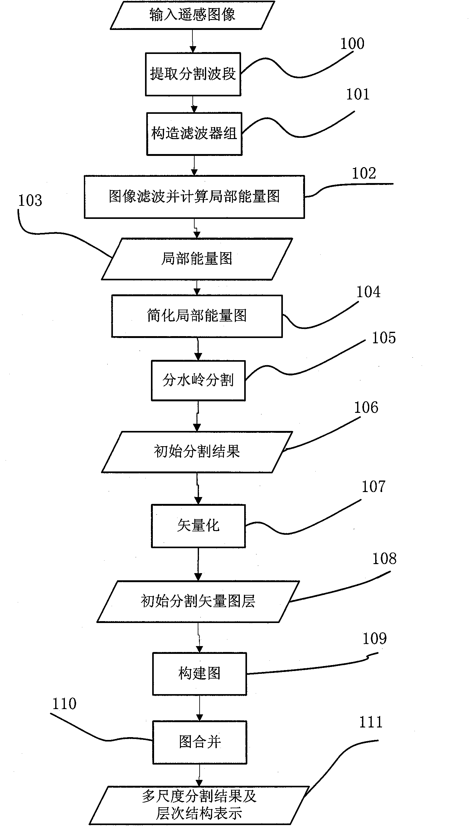
[0037] The implementation process of the boundary-preserving remote sensing image segmentation method of the present invention is as follows: figure 1 as shown, figure 1 Consists of 12 units. The graph merging in this embodiment will be described by taking the Boruvka algorithm of the minimum spanning tree as an example.

[0038] Unit 100 is an extraction split-band unit. Remote sensing images, especially multispectral images, usually have more than three bands. However, image segmentation is often performed on a band, so it is necessary to extract the band to be segmented. For the panchromatic band, it can be segmented directly in this band; for the multi-spectral band, select one of the bands or segment on the combined image of the bands, or segment on the component after spectral transformation, such as the first component after...


PUM


Abstract

The invention provides a multi-scale image segmentation method for a remote sensing image with boundary maintenance characteristics. The method comprises the following steps of: filtering the image by using an orthogonal filter bank and then solving a preprocessing method for a local energy diagram of the image; accurately positioning and detecting a ground feature boundary; performing watershed segmentation on the preprocessed image to obtain an initial segmentation result; vectoring the initial segmentation result to generate a segmentation vector diagram layer so as to express each segmentation region by using a polygonal vector and establish adjacency relation between vector polygons; constructing a diagram for a polygonal vector diagram layer; combining the segmentation regions by combining threshold control based on a minimal spanning tree algorithm of the diagram; and iteratively performing the diagram combination process until the required scale segmentation hierarchy and structure are formed.

Description

technical field [0001] The invention relates to a remote sensing image processing technology, in particular to a multi-scale remote sensing image segmentation method with boundary preservation characteristics. Background technique [0002] High spatial resolution remote sensing images provide a wealth of information about the geometric structure, texture details, and spectrum of ground objects, and have broad application prospects in large-scale remote sensing mapping, environmental monitoring, etc. Observe the detailed changes of the surface on the scale and monitor the impact of human activities on the environment. [0003] One of the important ways to apply high spatial resolution remote sensing images is to use image segmentation technology to segment remote sensing images into homogeneous regions, and then use the spectral information, texture information, geometric structure and topological information of ground objects to identify ground objects. Different ground obj...

Claims


Application Information

Patent Timeline
Patent Type & Authority Applications(China)
IPC IPC(8): G06T7/00
Inventor 唐娉冯峥边钊霍连志
Owner REMOTE SENSING APPLIED INST CHINESE ACAD OF SCI
Why Eureka
Try Eureka