
Method for measuring tree-level parameters of deciduous forest based on small-spot airborne radar

An airborne radar and parameter measurement technology, which is applied in the field of forest resources monitoring, can solve the problems of low density and resolution of understory vegetation, lack of understory tree information, and difficulty in detecting canopy edges, etc., to improve the overall accuracy , reduce over-segmentation, and strong robustness

Active Publication Date: 2021-04-02
HUNAN INST OF TECH
View PDF4 Cites 0 Cited by
  • Summary
  • Abstract
  • Description
  • Claims
  • Application Information

AI Technical Summary

Problems solved by technology

[0004] At present, the main technologies for single tree detection are: methods based on canopy height model (CHM) or digital surface model (DSM), and the recent technology that directly uses the original lidar point cloud method, but these technologies and The method is often unable to detect the understory trees in the forest with complex structure, and it is difficult to detect the edge of the canopy, and usually oversimplifies the geometry of the canopy. It can be said that these methods have an inherent shortcoming, that is, in the segmentation process of a single tree In the above, due to only focusing on the surface data, the understory leaf tree information is missing. Furthermore, the existing methods implement the same resolution threshold segmentation process for the upper and lower canopy, ignoring the fact that their lidar point densities are different. lead to over-segmentation of the lower tree
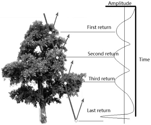
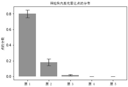
The overall accuracy of the understory trees (usually around 60%) of these methods is always lower than that of the upper forest trees (usually about 90% or more), and the main reason for this defect is the occlusion effect of the high-level tree canopy, which greatly reduces Penetration of lidar pulses into lower vegetation layers, which results in much lower density and resolution of points delineating the underlying vegetation, makes deciduous forest inventories less accurate

Method used


Image

  • Method for measuring tree-level parameters of deciduous forest based on small-spot airborne radar
  • Method for measuring tree-level parameters of deciduous forest based on small-spot airborne radar
  • Method for measuring tree-level parameters of deciduous forest based on small-spot airborne radar

Examples


Embodiment Construction

[0056] In order to facilitate the understanding of those skilled in the art, the present invention will be further described below in conjunction with the embodiments and accompanying drawings, and the contents mentioned in the embodiments are not intended to limit the present invention.

[0057] The implementation site for this example is Robinson Forest (coordinates: 37°28'23"N 83° 08'36"W), located in the rugged Cumberland Plateau in Brissett, Perry, and Knott counties in southeastern Kentucky the eastern section. The area is a diverse, contiguous mixed mesophyte forest with approximately 80 tree species, including northern red oak (Quercus rubra L.), white oak (Quercusalba L.), boxwood (Liriodendron tulipifera L.), American Beech (Fagus grandifolia Ehrh.), eastern hemlock (Tsuga canadensis (L.) Carrière) and sugar maple (Acer saccharum Marsh.) and other dominant and secondary dominant trees. Understory plants include Cercis canadensis L., Cornus florida L., Lindera benzoi...


PUM


Abstract

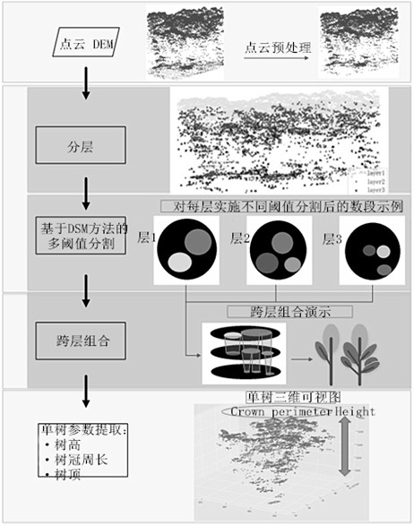
The invention, which relates to the technical field of forest resource monitoring, provides a deciduous forest tree-level parameter measuring method based on a small spot airborne radar. The method comprises: carrying out laser radar scanning on a deciduous forest area and collecting data; carrying out preprocessing and analysis on the obtained data to separate canopies at different heights; on the basis of a digital surface model (DSM)-based method, carrying out segmentation of different resolution thresholds on each isolated canopy; combining tree segment across layers segmented at all layers and drawing a single tree; and extracting tree-level parameters to complete measurement of corresponding deciduous forest tree-level parameters. According to the method provided by the invention, anaverage detection rate and average overall accuracy of the leaf tree under the forest can be improved obviously and the obtain overall precision of all trees is improved. A solution having the broadprospects is provided for effective and robust single tree segmentation.

Description

technical field [0001] The invention relates to the technical field of forest resources monitoring, in particular to a method for measuring tree-level parameters of deciduous forests based on small-spot airborne radar. Background technique [0002] The main purpose of forest resource inventory is to conduct forest management and decision-making analysis (such as improved harvesting, forest stock, growth prediction and afforestation design, etc.) by investigating the distribution and quality changes of various forest resources. The traditional method is to manually conduct a large number of field surveys on standard sample plots, and use tree-level parameters such as diameter at breast height, canopy diameter, and tree height of a single tree in the sample data to estimate the stand information of the entire forest, which not only consumes a lot of manpower Resource and time costs, and the obtained parameters also have certain errors. [0003] Over the past few decades, airb...

Claims


Application Information

Patent Timeline
Patent Type & Authority Patents(China)
IPC IPC(8): G01S17/894G01B11/24
CPCG01B11/24G01S17/89
Inventor 黄银珍王小虎罗泽黄海波洪俊
Owner HUNAN INST OF TECH
Learn More