

An incremental map update method based on national basic geographic information data
A national basic geography and incremental map technology, which is applied in digital data processing, special data processing applications, maps/plans/charts, etc., can solve the problem of insufficient incremental updating and mapping, and achieve fast mapping, obvious effects, and The effect of meeting the needs of drawing
- Summary
- Abstract
- Description
- Claims
- Application Information
AI Technical Summary
Problems solved by technology
Method used
Image

Examples
Embodiment Construction
[0065] In order to facilitate those of ordinary skill in the art to understand and implement the present invention, the present invention will be further described in detail below with reference to the accompanying drawings and specific embodiments.
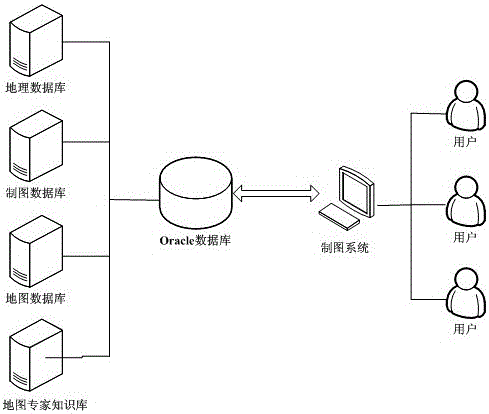
[0066] The system architecture running in the embodiment of the present invention adopts the existing technology, such as figure 1 As shown, it contains three parts: database, drawing system and end user. This structure utilizes existing computer database technology. In the embodiment, the database used is an Oracle database. According to the needs of computer cartography, the database includes four types: geographic database, cartographic database, map database and map expert knowledge base. The geographic database stores geographic data, that is, the original DLG (Digital Line Graphic) digital line drawing data and its metadata, which are the most basic data for computer map mapping; the cartographic database stores cartographic da...
PUM
 Abstract
Description
Claims
Application Information