Aerial photogrammetric system integrated with non-scanning laser radar and aerial photogrammetric method

A laser radar and aerial photography technology, which is applied in the field of aerial photogrammetry system integrating non-scanning laser radar, can solve the problems of long mapping cycle, increased mapping cycle and cost, and low efficiency, so as to improve the mapping ability and shorten the Effect of drawing cycle and cost reduction

Active Publication Date: 2016-07-20
MIANYANG SKYEYE LASER TECH
View PDF4 Cites 9 Cited by
  • Summary
  • Abstract
  • Description
  • Claims
  • Application Information

AI Technical Summary

Problems solved by technology

At present, the methods of POS-assisted aerial photogrammetry mainly include Direct Georeferencing (DirectGeoreferencing, DG) and POS-assisted aerial triangulation method (IntegratedSensorOrientation, ISO). The POS measurement data is processed and error corrected to obtain the external orientation elements of the aerial camera to realize directional mapping, but it is necessary to correct the eccentric component and eccentricity between the GPS antenna, IMU and the projection center of the aerial camera during the aerial photography process through cumbersome means Otherwise, the mapping accuracy will be greatly affected. Even so, the aerial survey accuracy of the direct orientation method still cannot meet the requirements of large-scale and high-precision mapping; the POS-assisted aerial triangulation method uses the outer orientation elements obtained according to the IMU / DGPS measurement correction as the area Bringing the weighted observations of the network adjustment into the calculation can obtain higher-precision azimuth elements outside the aerial camera. However, in order to improve the accuracy of the mapping, a small number of ground control points still need to be introduced, which increases the mapping cycle and cost to a certain extent.
[0004] In the process of realizing the present invention, the inventors found that the traditional aerial photogrammetry in the prior art generally has the defects of long mapping cycle, low efficiency, high cost and limited by terrain, which cannot effectively meet the requirements of national economic construction and national development strategy. The demand for geographic information data acquisition and the use of complex mechanical scanning units make the structure complex and other defects

Method used


Image

  • Aerial photogrammetric system integrated with non-scanning laser radar and aerial photogrammetric method
  • Aerial photogrammetric system integrated with non-scanning laser radar and aerial photogrammetric method
  • Aerial photogrammetric system integrated with non-scanning laser radar and aerial photogrammetric method

Examples


Embodiment Construction

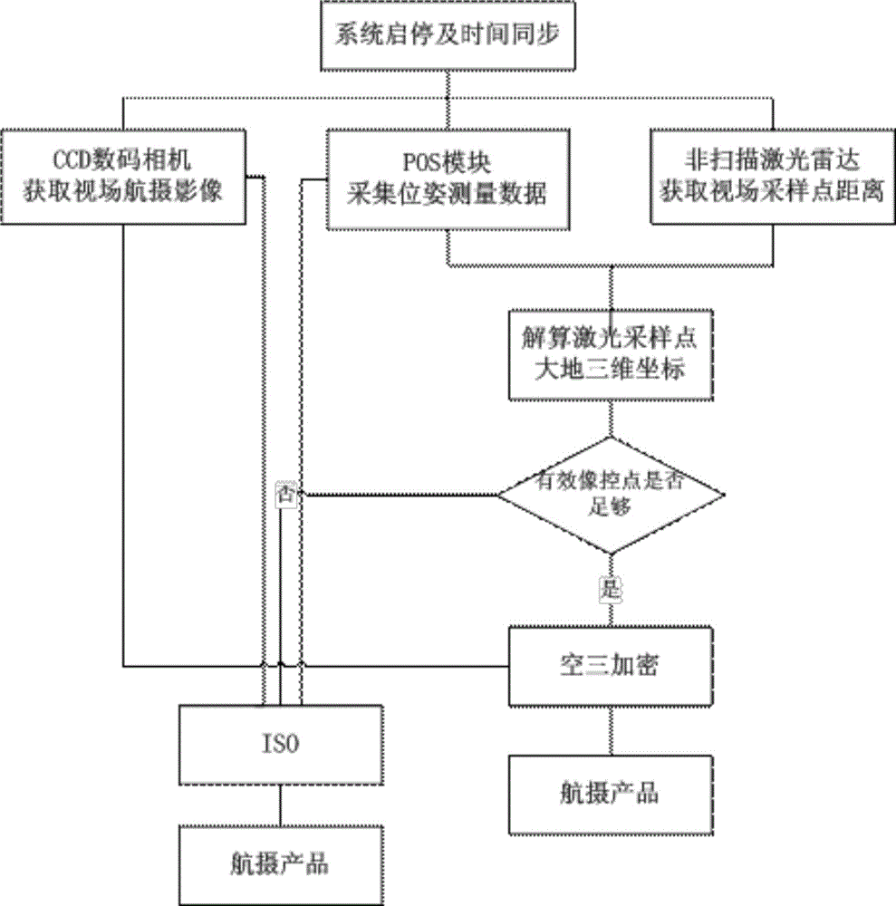
[0031] The preferred embodiments of the present invention will be described below in conjunction with the accompanying drawings. It should be understood that the preferred embodiments described here are only used to illustrate and explain the present invention, and are not intended to limit the present invention.

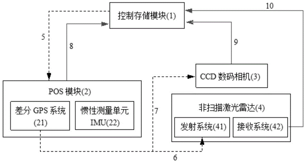
[0032] According to an embodiment of the present invention, such as figure 1 As shown, an aerial photogrammetry system integrating non-scanning lidar is provided.

[0033] seefigure 1 , the integrated non-scanning laser radar aerial photogrammetry system of this embodiment is as follows:

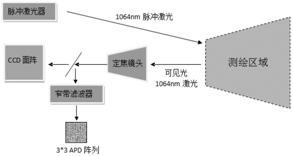
[0034] Including non-scanning laser radar, CCD digital camera, positioning and orientation POS module, control storage module, first instruction transmission cable, second instruction transmission cable, third instruction transmission cable, first data transmission cable, second data transmission cable a transmission cable and a third data transmission cable;

[0035] The POS mo...


PUM


Abstract

The invention discloses an aerial photogrammetric system integrated with a non-scanning laser radar and an aerial photogrammetric method. The system comprises the non-scanning laser radar, a CCD (Charge Coupled Device) digital camera, a positioning-orienting POS (Passive Optical Splitter) module and a control-storage module. The method comprises the following steps of carrying out multiple-laser-beam irradiation on a visual field range by the non-scanning laser radar based on a focal plane array, so as to determine the distances of many sampling points in a visual field; meanwhile, by utilizing pose data provided by the positioning-orienting POS module, resolving out the geodetic three-dimensional coordinate of each sampling point as ground control information of subsequent aerial photographic processing; collecting an aerial photogrammetric photo of the same visual field by the CCD digital camera, realizing aerial survey mapping according to the information, which is provided by the laser radar, of a ground control point in quick and low-cost manners. According to the aerial photogrammetric system integrated with the non-scanning laser radar and the aerial photogrammetric method, a conventional field ground control method is replaced by adopting the three-dimensional imaging by the non-scanning laser radar; a charting period can be greatly shortened; the cost is decreased; the mapping capacity of a zone which is severe in geographical environment is improved.

Description

technical field [0001] The invention relates to the field of aerial photogrammetry, in particular to an aerial photogrammetry system and method integrating non-scanning laser radar. Background technique [0002] Aerial photogrammetry is an important technical means to quickly obtain geographic information data, and then carry out basic surveying and mapping, geological survey, land and resources development and other businesses, and it is also one of the most important data sources for making and updating topographic maps. Aerial photogrammetry technology obtains the spatial three-dimensional coordinates of the corresponding object points by intersecting the projected beams of the same-named image points on the stereo image pair. In order to restore the spatial position and attitude of each projected ray on the photographic image at the time of photographic exposure, it is necessary to obtain the inner orientation elements of the aerial camera and the outer orientation eleme...

Claims


Application Information

Patent Timeline
Patent Type & Authority Applications(China)
IPC IPC(8): G01C11/00G01S17/02G01S17/08G01S19/47G01C21/16
CPCG01C11/00G01C21/165G01S17/08G01S17/86G01S19/47
Inventor 唐丹潘文武窦延娟赵平王欣王国亮杨浩
Owner MIANYANG SKYEYE LASER TECH
Why Eureka
Try Eureka