A Transformation Method of GNSS Raw Observation Data

A technology of original observation data and original code, which is applied in the fields of geodesy and satellite navigation to achieve the effect of confidential processing

Inactive Publication Date: 2018-06-15
CHINESE ACAD OF SURVEYING & MAPPING
View PDF4 Cites 0 Cited by
  • Summary
  • Abstract
  • Description
  • Claims
  • Application Information

AI Technical Summary

Problems solved by technology

[0004] The object of the present invention is to provide a kind of GNSS raw observation data conversion method, thus solve the foregoing problems existing in the prior art

Method used


Image

  • A Transformation Method of GNSS Raw Observation Data
  • A Transformation Method of GNSS Raw Observation Data
  • A Transformation Method of GNSS Raw Observation Data

Examples


Embodiment

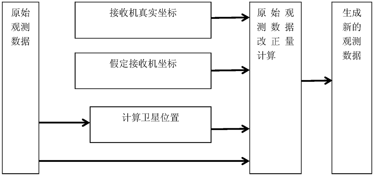
[0037] GNSS original observation data transformation method of the present invention, described method comprises:

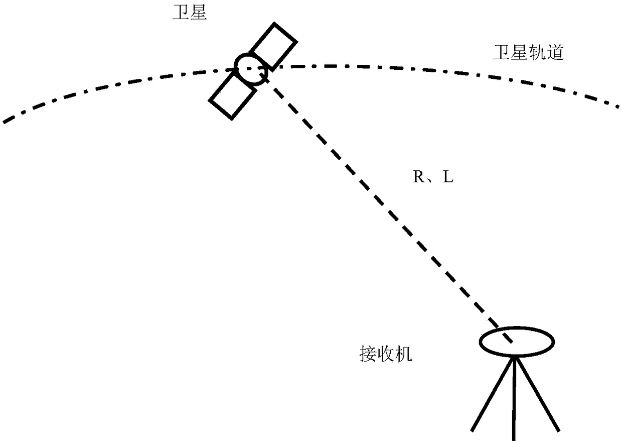
[0038] S1, obtain the GNSS original observation data between the receiver I observation and any satellite i; the GNSS original observation data includes the original code pseudorange R and the original carrier phase observation value L; set the satellite i The space coordinates are (Xs, Ys, Zs);

[0039] S2, setting the spatial coordinates of a hypothetical receiver I' that is correlated with the receiver I, denoted as (Xr', Yr', Zr');

[0040] On the basis of the GNSS original observation data, the real coordinate solution of receiver I and the satellite position calculation are carried out, and finally the spatial coordinates of the real position of the receiver I are obtained by combining the spatial coordinates of the assumed receiver I', denoted as (Xr ,Yr,Zr);

[0041] The correlation includes that the linear distance between the receiver I and the hypoth...


PUM


Abstract

The invention discloses a GNSS original observation data conversion method, and relates to the satellite navigation field and the geodetic survey field. The GNSS original observation data conversion method comprises steps that GNSS original observation data between a receiver I and any satellite i is observed by the receiver I , and is acquired, and a space coordinate of a hypothetic receiver I' related to the receiver I is set; on the basis of the GNSS original observation data, receiver I actual coordinate resolving and satellite position calculating are carried out, and finally, by combing with the space coordinate of the hypothetic receiver I', the space coordinate of the actual position of the receiver I is acquired; an original code pseudo range R' after conversion is calculated by adopting R'=R+d rho; an original carrier wave phase observed value L' after the conversion is calculated by adopting a formula L'=L+ d rho / c f. THE GNSS original observation data conversion method is advantageous in that high precision satellite navigation positioning reference station coordinate and observed data confidential treatment is realized, and at the same time, the new observed data has function and performance, which are the same as that of the original data, during relative positioning and differential positioning.

Description

technical field [0001] The invention relates to the fields of satellite navigation and geodetic survey, in particular to a method for transforming GNSS original observation data. Background technique [0002] The basic principle of satellite navigation and positioning is to use the Euclidean distance from multiple satellites to the receiver for spatial geometric intersection to obtain the spatial position of the receiver. Because in essence, the original observation data of the receiver is closely related and equivalent to the spatial position of the receiver, so the spatial coordinates of the receiver can be calculated very accurately through long-term static observation. [0003] In the prior art, the completion of obtaining the observation data will inevitably involve the leakage of the real position of the receiver, so a method is needed to ensure the integrity of various information of the observation data on the basis of hiding the real position of the receiver. Cont...

Claims


Application Information

Patent Timeline
Patent Type & Authority Patents(China)
IPC IPC(8): G01S19/37
CPCG01S19/37
Inventor 程鹏飞蔡艳辉徐彦田
Owner CHINESE ACAD OF SURVEYING & MAPPING
Why Eureka
Try Eureka